 |
|
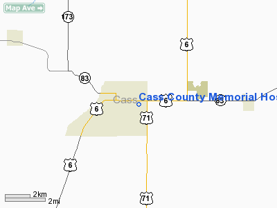
Cass County Memorial Hospital Heliport |
Location
& QuickFacts
|
FAA Information Effective: |
2007-07-05 |
|
Airport
Identifier: |
IA67 |
|
Airport
Status: |
Operational |
|
Longitude/Latitude: |
094-59-30.9560W/41-24-03.9620N
-94.991932/41.401101 (Estimated) |
|
Elevation: |
1250 ft / 381.00 m (Estimated) |
|
Land: |
0 acres |
|
From
nearest city: |
0 nautical miles N of Atlantic, IA |
|
Location: |
Cass County, IA |
|
Magnetic Variation: |
05E (1990) |
Owner
& Manager
|
Ownership: |
Publicly owned |
|
Owner: |
Cass County |
|
Address: |
1501 E 10th
Atlantic, IA 50022 |
|
Phone number: |
712-243-3250 |
|
Manager: |
Director Of Plant Operation |
|
Address: |
1501 E 10th
Atlantic, IA 50022 |
|
Phone number: |
712-243-3250 |
Airport
Operations and Facilities
|
Airport Use: |
Private
MEDICAL USE. |
|
Wind
indicator: |
Yes |
|
Segmented
Circle: |
No |
|
Control
Tower: |
No |
|
Lighting
Schedule: |
PHONE REQ
FOR LIGHTS CALL 712-243-3250. |
|
Sectional
chart: |
Omaha |
|
Region: |
ACE - Central |
|
Boundary
ARTCC: |
ZMP - Minneapolis |
|
Tie-in
FSS: |
FOD - Fort Dodge |
|
FSS
on Airport: |
No |
|
FSS
Phone: |
515-955-8114 |
|
FSS
Toll Free: |
1-800-WX-BRIEF |
|
Runway Information
Helipad H1
|
Dimension: |
58
x 58 ft / 17.7 x 17.7 m
CIRCULAR PAD. |
|
Surface: |
CONC, |
|
|
Runway H1 |
Runway |
|
Traffic
Pattern: |
Left |
Left |
|
Radio Navigation
Aids
|
ID |
Type |
Name |
Ch |
Freq |
Var |
Dist |
|
AIO |
NDB |
Atlantic |
|
365.00 |
04E |
2.5 nm |
|
ADU |
NDB |
Audubon |
|
266.00 |
04E |
17.8 nm |
|
HNR |
NDB |
Harlan |
|
272.00 |
05E |
19.0 nm |
|
GFZ |
NDB |
Greenfield |
|
338.00 |
04E |
25.1 nm |
|
RDK |
NDB |
Red Oak |
|
230.00 |
04E |
26.0 nm |
|
CRZ |
NDB |
Corning |
|
278.00 |
04E |
26.5 nm |
|
GCT |
NDB |
Guthrie Center |
|
518.00 |
05E |
30.3 nm |
|
DNS |
NDB |
Denison |
|
350.00 |
04E |
39.1 nm |
|
UNE |
NDB |
Union County |
|
379.00 |
04E |
39.5 nm |
|
CIN |
NDB |
Carroll |
|
397.00 |
04E |
39.8 nm |
|
ICL |
NDB |
Clarinda |
|
353.00 |
04E |
40.6 nm |
|
SDA |
NDB |
Shenandoah |
|
411.00 |
05E |
43.3 nm |
|
OM |
NDB |
Gerfi |
|
320.00 |
05E |
43.5 nm |
|
PRO |
NDB |
Perry |
|
251.00 |
06E |
45.4 nm |
|
EFW |
NDB |
Jefferson |
|
391.00 |
03E |
46.9 nm |
|
PMV |
NDB |
Plattsmouth |
|
329.00 |
06E |
49.9 nm |
|
OFF |
TACAN |
Offutt |
054X |
|
05E |
44.4 nm |
|
OVR |
VORTAC |
Omaha |
110X |
116.30 |
08E |
36.5 nm |
|
OMA |
VOT |
Omaha |
|
109.00 |
|
40.9 nm |
Remarks
- OWNER
DESIRES HELIPORT NOT BE CHARTED.
- PRVDD
MINIMUM 8:1 GLIDE SLOPE MAINTD FOR APCH/DEP; A MINIMUM 2:1 TRANSL SFC
MAINTD AND THE INGRESS/EGRESS ARE SOUTH SOUTHEAST.
Cass County Memorial Hospital Heliport
Address:
Cass County, IA
Tel:
712-243-3250
Images
and information placed above are from
http://www.airport-data.com/airport/IA67/
We
thank them for the data!
| General
Info |
| Country |
United
States |
| State |
IOWA
|
| FAA ID |
IA67
|
| Latitude |
41-24-03.962N
|
| Longitude |
094-59-30.956W
|
| Elevation |
1250 feet
|
| Near City |
ATLANTIC
|
We don't guarantee the information is fresh and accurate. The data may
be wrong or outdated.
For more up-to-date information please refer to other sources.
|
|


