 |
|
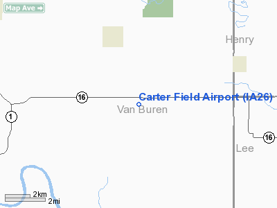
Location
& QuickFacts
|
FAA Information Effective: |
2007-07-05 |
|
Airport
Identifier: |
IA26 |
|
Airport
Status: |
Operational |
|
Longitude/Latitude: |
091-48-30.6030W/40-48-30.1020N
-91.808501/40.808362 (Estimated) |
|
Elevation: |
750 ft / 228.60 m (Estimated) |
|
Land: |
5
acres |
|
From
nearest city: |
3 nautical miles SE of Stockport, IA |
|
Location: |
Van Buren County, IA |
|
Magnetic Variation: |
03E (1985) |
Owner
& Manager
|
Ownership: |
Privately owned |
|
Owner: |
William C Carter |
|
Address: |
Route 1
Stockport, IA 52651 |
|
Phone number: |
319-796-4397 |
|
Address: |
|
Airport
Operations and Facilities
|
Airport Use: |
Private |
|
Wind indicator: |
Yes |
|
Segmented Circle: |
No |
|
Control Tower: |
No |
|
Landing fee charge: |
No |
|
Sectional chart: |
Chicago |
|
Region: |
ACE - Central |
|
Boundary ARTCC: |
ZAU - Chicago |
|
Tie-in FSS: |
FOD - Fort Dodge |
|
FSS on Airport: |
No |
|
FSS Phone: |
515-955-8114 |
|
FSS Toll Free: |
1-800-WX-BRIEF |
Airport
Services
|
Airframe Repair: |
NONE |
|
Power Plant Repair: |
NONE |
|
Runway Information
Runway 18/36
|
Dimension: |
2640 x 80 ft / 804.7 x 24.4 m |
|
Surface: |
TURF, Fair Condition |
|
|
Runway 18 |
Runway 36 |
|
Traffic
Pattern: |
Left |
Left |
|
Obstruction: |
17 ft road, 50.0 ft from runway, 2:1 slope
to clear |
, 50:1 slope to clear |
|
Radio Navigation
Aids
|
ID |
Type |
Name |
Ch |
Freq |
Var |
Dist |
|
FFL |
NDB |
Fairfield |
|
332.00 |
03E |
14.7 nm |
|
MPZ |
NDB |
Mount Pleasant |
|
212.00 |
02E |
15.8 nm |
|
EOK |
NDB |
Keokuk |
|
366.00 |
02E |
26.8 nm |
|
BEX |
NDB |
Bloomfield |
|
269.00 |
02E |
28.6 nm |
|
AWG |
NDB |
Washington |
|
219.00 |
02E |
29.0 nm |
|
OOA |
NDB |
Oskaloosa |
|
414.00 |
03E |
39.7 nm |
|
OTM |
VOR/DME |
Ottumwa |
053X |
111.60 |
06E |
27.0 nm |
|
DDD |
VOR/DME |
Port City |
112X |
116.50 |
01E |
44.9 nm |
|
BRL |
VORTAC |
Burlington |
051X |
111.40 |
05E |
40.5 nm |
|
IOW |
VORTAC |
Iowa City |
109X |
116.20 |
05E |
43.6 nm |
Remarks
- DURING
WINTER MONTHS CALL FOR ARPT CONDITIONS - 319-796-4397.
- CONDITIONAL
- PROVIDED THE APPROACH TO EACH RWY IS MAINTAINED FOR A MINIMUM 20:1
GLIDE SLOPE AND THE TRANSITIONAL SURFACE BE MAINTAINED FOR A 7:1 SLOPE.
Based
Aircraft
|
Aircraft
based on field: |
1 |
|
Multi
Engine Airplanes: |
1 |
Operational Statistics
Time Period: 1992-06-23
- 1993-06-22
|
Aircraft
Operations: |
25/Month |
|
General
Aviation Local: |
66.7% |
|
General
Aviation Itinerant: |
33.3% |
Carter Field Airport
Address:
Van Buren County, IA
Tel:
319-796-4397
Images
and information placed above are from
http://www.airport-data.com/airport/IA26/
We
thank them for the data!
| General
Info |
| Country |
United
States |
| State |
IOWA
|
| FAA ID |
IA26
|
| Latitude |
40-48-30.102N
|
| Longitude |
091-48-30.603W
|
| Elevation |
750 feet
|
| Near City |
STOCKPORT
|
We don't guarantee the information is fresh and accurate. The data may
be wrong or outdated.
For more up-to-date information please refer to other sources.
|
|


