 |
|
Bloomfield Municipal Airport |
| Bloomfield Municipal Airport |
| IATA: none – ICAO: none – FAA LID: 4K6 |
| Summary |
| Airport type |
Public |
| Owner |
City of Bloomfield |
| Serves |
Bloomfield, Iowa |
| Elevation AMSL |
888 ft / 271 m |
| Coordinates |
40°43′56″N 092°25′42″W / 40.73222°N 92.42833°W / 40.73222; -92.42833 |
| Runways |
| Direction |
Length |
Surface |
| ft |
m |
| 18/36 |
3,401 |
1,037 |
Concrete |
| Statistics (2006) |
| Aircraft operations |
4,868 |
| Source: Federal Aviation Administration |
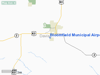
Bloomfield Municipal Airport (FAA LID: 4K6) is a city-owned, public-use airport located two miles (3 km) southwest of the central business district of Bloomfield, a city in Davis County, Iowa, United States.
Facilities and aircraft
Bloomfield Municipal Airport covers an area of 43 acres (17 ha) and has one runway designated 18/36 with a concrete surface measuring 3,401 by 50 feet (1,037 by 15 m). For the 12-month period ending May 18, 2006, the general aviation airport had 4,868 aircraft operations, an average of 13 per day.
The above content comes from Wikipedia and is published under free licenses – click here to read more.
Location
& QuickFacts
|
FAA Information Effective: |
2007-07-05 |
|
Airport
Identifier: |
4K6 |
|
Airport
Status: |
Operational |
|
Longitude/Latitude: |
092-25-41.7680W/40-43-55.5800N
-92.428269/40.732106 (Estimated) |
|
Elevation: |
888 ft / 270.66 m (Surveyed) |
|
Land: |
43
acres |
|
From
nearest city: |
2 nautical miles SW of Bloomfield, IA |
|
Location: |
Davis County, IA |
|
Magnetic Variation: |
02E (2000) |
Owner
& Manager
|
Ownership: |
Publicly owned |
|
Owner: |
City Of Bloomfield |
|
Address: |
111 W Franklin St
Bloomfield, IA 52537 |
|
Phone
number: |
641-664-2260 |
|
Manager: |
Duke Ball |
|
Address: |
Muni Arpt 20956 230th St
Bloomfield, IA 52537 |
|
Phone number: |
641-664-1255
AFT HRS CALL 641-722-3816. |
Airport
Operations and Facilities
|
Airport Use: |
Open to public |
|
Wind
indicator: |
Yes |
|
Segmented
Circle: |
No |
|
Control
Tower: |
No |
|
Lighting
Schedule: |
DUSK-DAWN
ACTVT MIRL RY 18/36 - CTAF. |
|
Beacon
Color: |
Clear-Green (lighted land airport) |
|
Landing
fee charge: |
No |
|
Sectional
chart: |
Chicago |
|
Region: |
ACE - Central |
|
Boundary
ARTCC: |
ZAU - Chicago |
|
Tie-in
FSS: |
FOD - Fort Dodge |
|
FSS
on Airport: |
No |
|
FSS
Phone: |
515-955-8114 |
|
FSS
Toll Free: |
1-800-WX-BRIEF |
|
NOTAMs
Facility: |
FOD (NOTAM-d service avaliable) |
|
Federal Agreements: |
NY1 |
Airport
Communications
|
CTAF: |
122.800 |
|
Unicom: |
122.800 |
Airport
Services
|
Fuel available: |
100LL |
|
Airframe Repair: |
MAJOR |
|
Power Plant Repair: |
MAJOR |
|
Bottled
Oxygen: |
NONE |
|
Bulk
Oxygen: |
NONE |
|
Runway Information
Runway 18/36
|
Dimension: |
3401 x 50 ft / 1036.6 x 15.2 m |
|
Surface: |
CONC, Fair Condition |
|
Weight
Limit: |
Single wheel: 28000 lbs.
Dual wheel: 20000 lbs. |
|
Edge
Lights: |
Medium |
|
|
Runway 18 |
Runway 36 |
|
Longitude: |
092-25-42.0100W |
092-25-41.5920W |
|
Latitude: |
40-44-12.3480N |
40-43-38.7440N |
|
Elevation: |
883.00
ft |
888.00
ft |
|
Alignment: |
127 |
127 |
|
Traffic
Pattern: |
Left |
Left |
|
Markings: |
Non-precision instrument, Fair Condition |
Non-precision instrument, Fair Condition |
|
Obstruction: |
39 ft trees, 852.0 ft from runway, 144 ft right
of centerline, 15:1 slope to clear |
15 ft road, 600.0 ft from runway, 26:1 slope
to clear |
|
Radio Navigation
Aids
|
ID |
Type |
Name |
Ch |
Freq |
Var |
Dist |
|
BEX |
NDB |
Bloomfield |
|
269.00 |
02E |
0.8 nm |
|
TVK |
NDB |
Centerville |
|
290.00 |
04E |
21.7 nm |
|
FFL |
NDB |
Fairfield |
|
332.00 |
03E |
26.1 nm |
|
OOA |
NDB |
Oskaloosa |
|
414.00 |
03E |
29.8 nm |
|
MPZ |
NDB |
Mount Pleasant |
|
212.00 |
02E |
43.7 nm |
|
CNC |
NDB |
Chariton |
|
335.00 |
05E |
45.8 nm |
|
OXV |
NDB |
Knoxville |
|
284.00 |
03E |
46.0 nm |
|
PEA |
NDB |
Pella |
|
257.00 |
02E |
46.7 nm |
|
AWG |
NDB |
Washington |
|
219.00 |
02E |
47.5 nm |
|
EOK |
NDB |
Keokuk |
|
366.00 |
02E |
48.2 nm |
|
OTM |
VOR/DME |
Ottumwa |
053X |
111.60 |
06E |
18.4 nm |
|
IRK |
VORTAC |
Kirksville |
093X |
114.60 |
06E |
36.7 nm |
Remarks
- FOR
SVC AFTER HRS CALL 641-664-1607.
- CONDL-PRVD
THE APCH TO RWY IS MAINTAINED FOR A MINIMUM 20:1 GLIDE SLOPE AND THE
TRANSITIONAL SURFACE BE MAINTAINED FOR A 7:1 SLOPE.
Based
Aircraft
|
Aircraft
based on field: |
8 |
|
Single
Engine Airplanes: |
8 |
Operational Statistics
Time Period: 2005-05-19
- 2006-05-18
|
Aircraft
Operations: |
94/Week |
|
General
Aviation Local: |
43.2% |
|
General
Aviation Itinerant: |
56.8% |
Bloomfield Municipal Airport
Address:
Davis County, IA
Tel:
641-664-2260,
641-664-1255
Images
and information placed above are from
http://www.airport-data.com/airport/4K6/
We
thank them for the data!
| General
Info |
| Country |
United
States |
| State |
IOWA
|
| FAA ID |
4K6
|
| Latitude |
40-43-55.580N
|
| Longitude |
092-25-41.768W
|
| Elevation |
888 feet
|
| Near City |
BLOOMFIELD
|
We don't guarantee the information is fresh and accurate. The data may
be wrong or outdated.
For more up-to-date information please refer to other sources.
|
|


