 |
|
Belmond Municipal Airport |
|
|
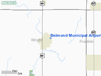
Location
& QuickFacts
|
FAA Information Effective: |
2007-07-05 |
|
Airport
Identifier: |
Y48 |
|
Airport
Status: |
Operational |
|
Longitude/Latitude: |
093-35-40.7530W/42-51-09.8870N
-93.594654/42.852746 (Estimated) |
|
Elevation: |
1201 ft / 366.06 m (Surveyed) |
|
Land: |
30
acres |
|
From
nearest city: |
1 nautical miles E of Belmond, IA |
|
Location: |
Wright County, IA |
|
Magnetic Variation: |
04E (1985) |
Owner
& Manager
|
Ownership: |
Publicly owned |
|
Owner: |
City Of Belmond |
|
Address: |
112 2nd Ave. Ne; P.o. Box 192
Belmond, IA 50421 |
|
Phone
number: |
641-444-3386 |
|
Manager: |
Lee Ann Waltzing |
|
Address: |
112 2nd Ave Ne; P.o. Box 192
Belmond, IA 50421 |
|
Phone number: |
641-444-3386 |
Airport
Operations and Facilities
|
Airport Use: |
Open to public |
|
Wind
indicator: |
Yes |
|
Segmented
Circle: |
No |
|
Control
Tower: |
No |
|
Lighting
Schedule: |
DUSK-DAWN
ACTVT LIRL RY 17/35 - CTAF. |
|
Landing
fee charge: |
No |
|
Sectional
chart: |
Omaha |
|
Region: |
ACE - Central |
|
Boundary
ARTCC: |
ZMP - Minneapolis |
|
Tie-in
FSS: |
FOD - Fort Dodge |
|
FSS
on Airport: |
No |
|
FSS
Phone: |
515-955-8114 |
|
FSS
Toll Free: |
1-800-WX-BRIEF |
|
NOTAMs
Facility: |
FOD (NOTAM-d service avaliable) |
Airport
Communications
Airport
Services
|
Airframe Repair: |
NONE |
|
Power Plant Repair: |
NONE |
|
Bottled
Oxygen: |
NONE |
|
Bulk
Oxygen: |
NONE |
|
Runway Information
Runway 17/35
|
Dimension: |
3245 x 95 ft / 989.1 x 29.0 m |
|
Surface: |
TURF, Good Condition |
|
Edge
Lights: |
Non-standard lighting system
RY 17/35 NSTD LIRL; LIGHTS MOUNTED ON NONFRANGIBLE STAKES. |
|
|
Runway 17 |
Runway 35 |
|
Traffic
Pattern: |
Left |
Left |
|
Obstruction: |
, 50:1 slope to clear |
30 ft tree, 610.0 ft from runway, 140 ft left
of centerline, 20:1 slope to clear |
|
Radio Navigation
Aids
|
ID |
Type |
Name |
Ch |
Freq |
Var |
Dist |
|
CAV |
NDB |
Clarion |
|
387.00 |
03E |
9.7 nm |
|
EAG |
NDB |
Eagle Grove |
|
302.00 |
03E |
16.4 nm |
|
HPT |
NDB |
Hampton |
|
230.00 |
03E |
18.0 nm |
|
FXY |
NDB |
Forest City |
|
359.00 |
05E |
23.0 nm |
|
IFA |
NDB |
Iowa Falls |
|
368.00 |
03E |
26.9 nm |
|
EBS |
NDB |
Webster City |
|
323.00 |
03E |
27.6 nm |
|
AXA |
NDB |
Algona |
|
403.00 |
03E |
32.8 nm |
|
IY |
NDB |
Chukk |
|
417.00 |
03E |
41.7 nm |
|
CCY |
NDB |
Charles City |
|
375.00 |
03E |
45.3 nm |
|
POH |
NDB |
Pocahontas |
|
428.00 |
06E |
46.9 nm |
|
BNW |
NDB |
Boone |
|
407.00 |
03E |
49.3 nm |
|
SBU |
NDB |
Blue Earth |
|
332.00 |
04E |
49.9 nm |
|
MCW |
VORTAC |
Mason City |
096X |
114.90 |
06E |
18.6 nm |
|
FOD |
VORTAC |
Fort Dodge |
082X |
113.50 |
07E |
34.2 nm |
Remarks
- LOOSE
GRVL IN TIEDOWN AREA AND TWYS - VERY ROUGH.
- ARPT
CLSD DEC-MAR EXCP PPR 641-444-3386.
Based
Aircraft
|
Aircraft
based on field: |
1 |
|
Ultralights: |
1 |
Operational Statistics
Time Period: 2003-05-13
- 2004-05-11
|
Aircraft
Operations: |
10/Week |
|
General
Aviation Local: |
40.0% |
|
General
Aviation Itinerant: |
60.0% |
Belmond Municipal Airport
Address:
Wright County, IA
Tel:
641-444-3386
Images
and information placed above are from
http://www.airport-data.com/airport/Y48/
We
thank them for the data!
| General
Info |
| Country |
United
States |
| State |
IOWA
|
| FAA ID |
Y48
|
| Latitude |
42-51-09.887N
|
| Longitude |
093-35-40.753W
|
| Elevation |
1201 feet
|
| Near City |
BELMOND
|
We don't guarantee the information is fresh and accurate. The data may
be wrong or outdated.
For more up-to-date information please refer to other sources.
|
|


