 |
|
Coordinates: 41°42â²05â³N 094°55â²14â³W / 41.70139°N 94.92056°W / 41.70139; -94.92056
| Audubon County Airport |
| IATA: none â ICAO: KADU â FAA LID: ADU |
| Summary |
| Airport type |
Public |
| Owner |
Audubon County Airport Authority |
| Location |
Audubon, Iowa |
| Elevation AMSL |
1,287 ft / 392 m |
| Runways |
| Direction |
Length |
Surface |
| ft |
m |
| 14/32 |
3,640 |
1,109 |
Concrete |
| Statistics (2005) |
| Aircraft operations |
2,562 |
| Source: Federal Aviation Administration |
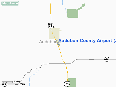
Audubon County Airport (ICAO: KADU, FAA LID: ADU), formerly Audubon Municipal Airport, is a public airport located one mile (2 km) southeast of the central business district of Audubon, a city in Audubon County, Iowa, United States. It is owned by the Audubon County Airport Authority.
Although most U.S. airports use the same three-letter location identifier for the FAA and IATA, Audubon County Airport is assigned ADU by the FAA but has no designation from the IATA (which assigned ADU to Ardabil Airport in Ardabil, Iran).
Facilities and aircraft
Audubon County Airport covers an area of 46 acres (19 ha) which contains one concrete paved runway (14/32) measuring 3,640 x 60 ft (1,109 x 18 m). For the 12-month period ending September 28, 2005, the airport had 2,562 aircraft operations: 96% general aviation and 4% air taxi.
The above content comes from Wikipedia and is published under free licenses – click here to read more.
Location
& QuickFacts
|
FAA Information Effective: |
2007-07-05 |
|
Airport
Identifier: |
ADU |
|
Airport
Status: |
Operational |
|
Longitude/Latitude: |
094-55-13.9500W/41-42-04.9520N
-94.920542/41.701376 (Estimated) |
|
Elevation: |
1287 ft / 392.28 m (Surveyed) |
|
Land: |
46
acres |
|
From
nearest city: |
1 nautical miles SE of Audubon, IA |
|
Location: |
Audubon County, IA |
|
Magnetic Variation: |
04E (1995) |
Owner
& Manager
|
Ownership: |
Publicly owned |
|
Owner: |
Audubon County Arpt Auth
LANCE LEWIS CHAIRMAN OFFICE# 712-563-2215. |
|
Address: |
Rt 2
Audubon, IA 50025 |
|
Phone number: |
712-563-2710 |
|
Manager: |
Charlie A. Goeken |
|
Address: |
2110 Highway 71
Audubon, IA 50025 |
|
Phone number: |
712-563-2710 |
Airport
Operations and Facilities
|
Airport Use: |
Open to public |
|
Wind
indicator: |
Yes |
|
Segmented
Circle: |
No |
|
Control
Tower: |
No |
|
Lighting
Schedule: |
DUSK-DAWN
ACTVT MIRL RY 14/32 AND PAPI & REIL RYS 14 & 32
- CTAF. |
|
Beacon
Color: |
Clear-Green (lighted land airport)
ROTG BCN OTS INDEFLY. |
|
Landing
fee charge: |
No |
|
Sectional
chart: |
Omaha |
|
Region: |
ACE - Central |
|
Boundary
ARTCC: |
ZMP - Minneapolis |
|
Tie-in
FSS: |
FOD - Fort Dodge |
|
FSS
on Airport: |
No |
|
FSS
Phone: |
515-955-8114 |
|
FSS
Toll Free: |
1-800-WX-BRIEF |
|
NOTAMs
Facility: |
ADU (NOTAM-d service avaliable) |
|
Federal Agreements: |
N1 |
Airport
Communications
|
CTAF: |
122.800 |
|
Unicom: |
122.800 |
Airport
Services
|
Fuel available: |
100LLMOGAS |
|
Airframe Repair: |
MAJOR |
|
Power Plant Repair: |
MAJOR |
|
Bottled
Oxygen: |
NONE |
|
Bulk
Oxygen: |
NONE |
|
Runway Information
Runway 14/32
|
Dimension: |
3640 x 60 ft / 1109.5 x 18.3 m |
|
Surface: |
CONC, Fair Condition |
|
Weight
Limit: |
Single wheel: 15000 lbs. |
|
Edge
Lights: |
Medium |
|
|
Runway 14 |
Runway 32 |
|
Longitude: |
094-55-25.6900W |
094-55-00.9500W |
|
Latitude: |
41-42-19.5200N |
41-41-49.9520N |
|
Elevation: |
1287.00
ft |
1279.00
ft |
|
Alignment: |
127 |
127 |
|
Traffic
Pattern: |
Left |
Left |
|
Markings: |
Non-precision instrument, Fair Condition |
Non-precision instrument, Fair Condition |
|
Crossing
Height: |
28.00
ft |
30.00
ft |
|
Displaced
threshold: |
130.00
ft |
0.00 ft |
|
VASI: |
2-light PAPI on left side |
2-light PAPI on left side |
|
Visual
Glide Angle: |
3.00° |
3.00° |
|
Runway
End Identifier: |
Yes |
Yes |
|
Obstruction: |
54 ft pole, 1200.0 ft from runway, 50 ft right
of centerline, 18:1 slope to clear
APCH SLOPE 20:1 TO DSPLCD THLD. |
33 ft pole, 720.0 ft from runway, 150 ft left
of centerline, 15:1 slope to clear |
|
Radio Navigation
Aids
|
ID |
Type |
Name |
Ch |
Freq |
Var |
Dist |
|
ADU |
NDB |
Audubon |
|
266.00 |
04E |
0.8 nm |
|
AIO |
NDB |
Atlantic |
|
365.00 |
04E |
18.7 nm |
|
HNR |
NDB |
Harlan |
|
272.00 |
05E |
20.3 nm |
|
CIN |
NDB |
Carroll |
|
397.00 |
04E |
21.5 nm |
|
GCT |
NDB |
Guthrie Center |
|
518.00 |
05E |
21.9 nm |
|
DNS |
NDB |
Denison |
|
350.00 |
04E |
26.7 nm |
|
GFZ |
NDB |
Greenfield |
|
338.00 |
04E |
31.1 nm |
|
EFW |
NDB |
Jefferson |
|
391.00 |
03E |
32.0 nm |
|
PRO |
NDB |
Perry |
|
251.00 |
06E |
34.9 nm |
|
SKI |
NDB |
Sac City |
|
356.00 |
04E |
40.9 nm |
|
CRZ |
NDB |
Corning |
|
278.00 |
04E |
43.0 nm |
|
RDK |
NDB |
Red Oak |
|
230.00 |
04E |
43.8 nm |
|
MEY |
NDB |
Mapleton |
|
335.00 |
05E |
48.6 nm |
|
OVR |
VORTAC |
Omaha |
110X |
116.30 |
08E |
48.8 nm |
|
OMA |
VOT |
Omaha |
|
109.00 |
|
49.9 nm |
Remarks
- RY
14 HAS 64 FT LGTD POLE 1200 FT FM THLD 350 FT L.
- 125
FT X 100 FT PARKING APRON.
Based
Aircraft
|
Aircraft
based on field: |
5 |
|
Single
Engine Airplanes: |
5 |
Operational Statistics
Time Period: 2004-09-29
- 2005-09-28
|
Aircraft
Operations: |
50/Week |
|
Air Taxi: |
3.9% |
|
General
Aviation Local: |
74.2% |
|
General
Aviation Itinerant: |
21.9% |
Audubon County Airport
Address:
Audubon County, IA
Tel:
712-563-2710
Images
and information placed above are from
http://www.airport-data.com/airport/ADU/
We
thank them for the data!
| General
Info |
| Country |
United
States |
| State |
IOWA
|
| FAA ID |
ADU
|
| Latitude |
41-42-04.952N
|
| Longitude |
094-55-13.950W
|
| Elevation |
1287 feet
|
| Near City |
AUDUBON
|
We don't guarantee the information is fresh and accurate. The data may
be wrong or outdated.
For more up-to-date information please refer to other sources.
|
|


