 |
|
| Arthur N. Neu Airport |
| IATA: CIN â ICAO: KCIN â FAA LID: CIN |
| Summary |
| Airport type |
Public |
| Owner |
City of Carroll |
| Serves |
Carroll, Iowa |
| Elevation AMSL |
1,204 ft / 367 m |
| Coordinates |
42°02â²46â³N 094°47â²20â³W / 42.04611°N 94.78889°W / 42.04611; -94.78889 |
| Website |
cityofcarroll.com/... |
| Runways |
| Direction |
Length |
Surface |
| ft |
m |
| 13/31 |
5,500 |
1,676 |
Concrete |
| 3/21 |
3,300 |
1,006 |
Concrete |
| Statistics (2007) |
| Aircraft operations |
7,700 |
| Based aircraft |
21 |
| Source: Federal Aviation Administration |
Arthur N. Neu Airport (IATA: CIN, ICAO: KCIN, FAA LID: CIN) is a city-owned public-use airport located four nautical miles (7 km) southeast of the central business district of Carroll, a city in Carroll County, Iowa, United States. It is also known as Arthur N. Neu Municipal Airport and was established at its current location in the 1940s.
Facilities and aircraft
Arthur N. Neu Airport covers an area of 300 acres (121 ha) at an elevation of 1,204 feet (367 m) above mean sea level. It has two concrete paved and lighted runways: Runway 13/31 is 5,500 by 100 feet (1,676 x 30 m) with registered instrument approach and non-directional beacon. Runway 3/21 is 3,300 by 60 feet (1,006 x 18 m).
For the 12-month period ending July 10, 2007, the airport had 7,700 aircraft operations, an average of 21 per day: 91% general aviation, 8% air taxi and <1% military. At that time there were 21 aircraft based at this airport: 86% single-engine, 10% multi-engine and 5% ultralight. The airport has hangar space for 24 aircraft.
The above content comes from Wikipedia and is published under free licenses – click here to read more.
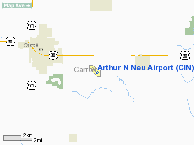
Location
& QuickFacts
|
FAA Information Effective: |
2007-07-05 |
|
Airport
Identifier: |
CIN |
|
Airport
Status: |
Operational |
|
Longitude/Latitude: |
094-47-20.4000W/42-02-46.3000N
-94.789000/42.046194 (Estimated) |
|
Elevation: |
1204 ft / 366.98 m (Surveyed) |
|
Land: |
169 acres |
|
From
nearest city: |
4 nautical miles SE of Carroll, IA |
|
Location: |
Carroll County, IA |
|
Magnetic Variation: |
04E (2000) |
Owner
& Manager
|
Ownership: |
Publicly owned |
|
Owner: |
City Of Carroll
NORMAN HUTCHESON CHMN ARPT CMSN, PHONE 792-2621. |
|
Address: |
112 East 5th St.
Carroll, IA 51401 |
|
Phone number: |
712-792-1000 |
|
Manager: |
Donald Mensen |
|
Address: |
21177 Quail Ave
Carroll, IA 51401 |
|
Phone number: |
712-792-4980 |
Airport
Operations and Facilities
|
Airport Use: |
Open to public |
|
Wind
indicator: |
Yes |
|
Segmented
Circle: |
No |
|
Control
Tower: |
No |
|
Lighting
Schedule: |
DUSK-DAWN
MIRL RY 13/31 & PAPI RYS 13 & 31 PRESET ON LOW INTST;
TO INCR INTST & ACTVT REIL RYS 13/31 - CTAF. |
|
Beacon
Color: |
Clear-Green (lighted land airport) |
|
Landing
fee charge: |
No |
|
Sectional
chart: |
Omaha |
|
Region: |
ACE - Central |
|
Boundary
ARTCC: |
ZMP - Minneapolis |
|
Tie-in
FSS: |
FOD - Fort Dodge |
|
FSS
on Airport: |
No |
|
FSS
Phone: |
515-955-8114 |
|
FSS
Toll Free: |
1-800-WX-BRIEF |
|
NOTAMs
Facility: |
CIN (NOTAM-d service avaliable) |
|
Federal Agreements: |
NGY |
Airport
Communications
|
CTAF: |
122.800 |
|
Unicom: |
122.800 |
Airport
Services
|
Fuel available: |
100
A MOGAS |
|
Airframe Repair: |
MAJOR |
|
Power Plant Repair: |
MAJOR |
|
Bottled
Oxygen: |
NONE |
|
Bulk
Oxygen: |
NONE |
|
Runway Information
Runway 03/21
|
Dimension: |
3300 x 60 ft / 1005.8 x 18.3 m |
|
Surface: |
CONC, Good Condition |
|
|
Runway 03 |
Runway 21 |
|
Longitude: |
094-47-30.2220W |
094-47-08.3900W |
|
Latitude: |
42-02-37.0360N |
42-03-05.2900N |
|
Alignment: |
30 |
127 |
|
Traffic
Pattern: |
Left |
Left |
|
Obstruction: |
15 ft road, 340.0 ft from runway, 22:1 slope
to clear |
4 ft fence, 125.0 ft from runway, 70 ft right
of centerline, 31:1 slope to clear |
|
Runway 13/31
|
Dimension: |
5500 x 100 ft / 1676.4 x 30.5 m |
|
Surface: |
CONC, Good Condition |
|
Weight
Limit: |
Single wheel: 30000 lbs. |
|
Edge
Lights: |
Medium |
|
|
Runway 13 |
Runway 31 |
|
Longitude: |
094-47-44.1770W |
094-46-54.1330W |
|
Latitude: |
42-03-06.0120N |
42-02-26.5060N |
|
Elevation: |
1204.00
ft |
1203.00
ft |
|
Alignment: |
127 |
127 |
|
Traffic
Pattern: |
Left |
Left |
|
Markings: |
Non-precision instrument, Good Condition |
Non-precision instrument, Good Condition |
|
Crossing
Height: |
23.00 ft |
26.00
ft |
|
Displaced
threshold: |
505.00
ft |
0.00 ft |
|
VASI: |
2-light PAPI on left side |
2-light PAPI on left side |
|
Visual
Glide Angle: |
3.00° |
3.00° |
|
Runway
End Identifier: |
Yes |
Yes |
|
Obstruction: |
34 ft rr, 1250.0 ft from runway, 250 ft left
of centerline, 30:1 slope to clear
APCH SLOPE 50:1 FROM DSPLCD THLD. |
, 50:1 slope to clear |
|
Radio Navigation
Aids
|
ID |
Type |
Name |
Ch |
Freq |
Var |
Dist |
|
CIN |
NDB |
Carroll |
|
397.00 |
04E |
0.2 nm |
|
EFW |
NDB |
Jefferson |
|
391.00 |
03E |
20.0 nm |
|
SKI |
NDB |
Sac City |
|
356.00 |
04E |
21.9 nm |
|
ADU |
NDB |
Audubon |
|
266.00 |
04E |
22.1 nm |
|
DNS |
NDB |
Denison |
|
350.00 |
04E |
26.6 nm |
|
GCT |
NDB |
Guthrie Center |
|
518.00 |
05E |
27.1 nm |
|
PRO |
NDB |
Perry |
|
251.00 |
06E |
30.9 nm |
|
HNR |
NDB |
Harlan |
|
272.00 |
05E |
37.4 nm |
|
SLB |
NDB |
Storm Lake |
|
434.00 |
04E |
39.0 nm |
|
AIO |
NDB |
Atlantic |
|
365.00 |
04E |
40.3 nm |
|
BNW |
NDB |
Boone |
|
407.00 |
03E |
41.8 nm |
|
POH |
NDB |
Pocahontas |
|
428.00 |
06E |
42.6 nm |
|
MEY |
NDB |
Mapleton |
|
335.00 |
05E |
45.6 nm |
|
GFZ |
NDB |
Greenfield |
|
338.00 |
04E |
46.0 nm |
|
EBS |
NDB |
Webster City |
|
323.00 |
03E |
47.3 nm |
|
FOD |
VORTAC |
Fort Dodge |
082X |
113.50 |
07E |
40.4 nm |
Remarks
Based
Aircraft
|
Aircraft
based on field: |
20 |
|
Single
Engine Airplanes: |
16 |
|
Multi
Engine Airplanes: |
3 |
|
Ultralights: |
1 |
Operational Statistics
Time Period: 2002-05-16
- 2003-05-15
|
Aircraft
Operations: |
120/Week |
|
Air Taxi: |
8.3% |
|
General
Aviation Local: |
50.8% |
|
General
Aviation Itinerant: |
40.5% |
|
Military: |
0.4% |
Arthur N Neu Airport
Address:
Carroll County, IA
Tel:
712-792-1000, 712-792-4980
Images
and information placed above are from
http://www.airport-data.com/airport/CIN/
We
thank them for the data!
| General
Info |
| Country |
United
States |
| State |
IOWA
|
| FAA ID |
CIN
|
| Latitude |
42-02-46.300N
|
| Longitude |
094-47-20.400W
|
| Elevation |
1204 feet
|
| Near City |
CARROLL
|
We don't guarantee the information is fresh and accurate. The data may
be wrong or outdated.
For more up-to-date information please refer to other sources.
|
|


