 |
|
Anita Municipal - Kevin Burke Memorial Field Airport |
Anita Municipal Airport
Kevin Burke Memorial Field |
| IATA: none – ICAO: none – FAA LID: Y43 |
| Summary |
| Airport type |
Public |
| Owner |
City of Anita |
| Serves |
Anita, Iowa |
| Elevation AMSL |
1,251 ft / 381 m |
| Coordinates |
41°26′25″N 094°46′11″W / 41.44028°N 94.76972°W / 41.44028; -94.76972 |
| Website |
www.AnitaIowa.com/... |
| Runways |
| Direction |
Length |
Surface |
| ft |
m |
| 5/23 |
2,825 |
861 |
Turf |
| Statistics (2009) |
| Aircraft operations |
1,000 |
| Source: Federal Aviation Administration |
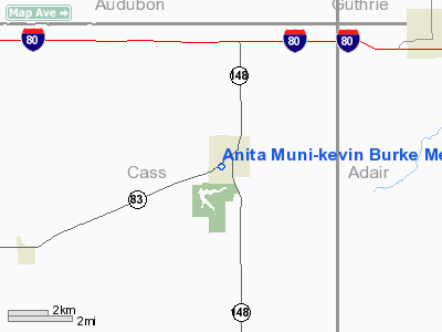
Anita Municipal Airport (FAA LID: Y43), also known as Kevin Burke Memorial Field, is a city-owned public-use airport located one nautical mile (2 km) south of the central business district of Anita, a city in Cass County, Iowa, United States.
Facilities and aircraft
Anita Municipal Airport covers an area of 40 acres (16 ha) at an elevation of 1,251 feet (381 m) above mean sea level. It has one runway designated 5/23 with a turf surface measuring 2,825 by 95 feet (861 x 29 m). For the 12-month period ending March 18, 2009, the airport had 1,000 general aviation aircraft operations, an average of 83 per month.
The above content comes from Wikipedia and is published under free licenses – click here to read more.
Location
& QuickFacts
|
FAA Information Effective: |
2007-07-05 |
|
Airport
Identifier: |
Y43 |
|
Airport
Status: |
Operational |
|
Longitude/Latitude: |
094-46-10.9250W/41-26-24.9540N
-94.769701/41.440265 (Estimated) |
|
Elevation: |
1251 ft / 381.30 m (Surveyed) |
|
Land: |
40
acres |
|
From
nearest city: |
1 nautical miles S of Anita, IA |
|
Location: |
Cass County, IA |
|
Magnetic Variation: |
05E (1985) |
Owner
& Manager
|
Ownership: |
Publicly owned |
|
Owner: |
City Of Anita |
|
Address: |
City Hall
Anita, IA 50020 |
|
Phone number: |
712-762-3746 |
|
Manager: |
Arlyn Lund |
|
Address: |
54833 750th Street
Anita, IA 50020 |
|
Phone number: |
712-762-4496
OR 712-762-3612. |
Airport
Operations and Facilities
|
Airport Use: |
Open to public |
|
Wind
indicator: |
Yes |
|
Segmented
Circle: |
No |
|
Control
Tower: |
No |
|
Lighting
Schedule: |
DUSK-DAWN |
|
Landing
fee charge: |
No |
|
Sectional
chart: |
Omaha |
|
Region: |
ACE - Central |
|
Traffic
Pattern Alt: |
900 ft |
|
Boundary
ARTCC: |
ZMP - Minneapolis |
|
Tie-in
FSS: |
FOD - Fort Dodge |
|
FSS
on Airport: |
No |
|
FSS
Phone: |
515-955-8114 |
|
FSS
Toll Free: |
1-800-WX-BRIEF |
|
NOTAMs
Facility: |
FOD (NOTAM-d service avaliable) |
Airport
Communications
Airport
Services
|
Bottled
Oxygen: |
NONE |
|
Bulk
Oxygen: |
NONE |
|
Runway Information
Runway 05/23
|
Dimension: |
2825 x 95 ft / 861.1 x 29.0 m |
|
Surface: |
TURF, Fair Condition |
|
Edge
Lights: |
Low |
|
|
Runway 05 |
Runway 23 |
|
Traffic
Pattern: |
Left |
Left |
|
Obstruction: |
21 ft tree, 78.0 ft from runway, 77 ft right
of centerline, 3:1 slope to clear
TREE 21' TALL 78' FROM RWY END 77' RIGHT ON APPROACH |
50 ft tree, 1100.0 ft from runway, 75 ft right
of centerline, 22:1 slope to clear |
|
Radio Navigation
Aids
|
ID |
Type |
Name |
Ch |
Freq |
Var |
Dist |
|
AIO |
NDB |
Atlantic |
|
365.00 |
04E |
12.7 nm |
|
GFZ |
NDB |
Greenfield |
|
338.00 |
04E |
16.2 nm |
|
ADU |
NDB |
Audubon |
|
266.00 |
04E |
16.3 nm |
|
GCT |
NDB |
Guthrie Center |
|
518.00 |
05E |
21.0 nm |
|
CRZ |
NDB |
Corning |
|
278.00 |
04E |
26.7 nm |
|
HNR |
NDB |
Harlan |
|
272.00 |
05E |
27.0 nm |
|
RDK |
NDB |
Red Oak |
|
230.00 |
04E |
33.6 nm |
|
UNE |
NDB |
Union County |
|
379.00 |
04E |
34.7 nm |
|
PRO |
NDB |
Perry |
|
251.00 |
06E |
36.0 nm |
|
CIN |
NDB |
Carroll |
|
397.00 |
04E |
36.4 nm |
|
EFW |
NDB |
Jefferson |
|
391.00 |
03E |
39.4 nm |
|
DNS |
NDB |
Denison |
|
350.00 |
04E |
42.6 nm |
|
ICL |
NDB |
Clarinda |
|
353.00 |
04E |
44.5 nm |
|
OVR |
VORTAC |
Omaha |
110X |
116.30 |
08E |
46.6 nm |
|
DSM |
VOT |
Des Moines |
|
109.20 |
|
49.7 nm |
Remarks
- DEER
ON AND INVOF ARPT.
- GARY
NEIGHBORS, CHAIRMAN ARPT COMMISSION.
Based
Aircraft
|
Aircraft
based on field: |
5 |
|
Single
Engine Airplanes: |
1 |
|
Ultralights: |
4 |
Operational Statistics
Time Period: 2005-05-04
- 2006-05-03
|
Aircraft
Operations: |
26/Month |
|
General
Aviation Local: |
50.0% |
|
General
Aviation Itinerant: |
50.0% |
Anita Municipal-kevin Burke Memorial Field Airport
Address:
Cass County, IA
Tel:
712-762-3746, 712-762-4496
Images
and information placed above are from
http://www.airport-data.com/airport/Y43/
We
thank them for the data!
| General
Info |
| Country |
United
States |
| State |
IOWA
|
| FAA ID |
Y43
|
| Latitude |
41-26-24.954N
|
| Longitude |
094-46-10.925W
|
| Elevation |
1251 feet
|
| Near City |
ANITA
|
We don't guarantee the information is fresh and accurate. The data may
be wrong or outdated.
For more up-to-date information please refer to other sources.
|
|


