 |
|
| Algona Municipal Airport |
| IATA: AXG – ICAO: KAXA – FAA LID: AXA |
| Summary |
| Airport type |
Public |
| Owner |
City of Algona |
| Serves |
Algona, Iowa |
| Elevation AMSL |
1,219 ft / 372 m |
| Coordinates |
43°04′40″N 094°16′19″W / 43.07778°N 94.27194°W / 43.07778; -94.27194 |
| Runways |
| Direction |
Length |
Surface |
| ft |
m |
| 12/30 |
3,960 |
1,207 |
Concrete |
| 18/36 |
2,880 |
878 |
Turf |
| Statistics (2005) |
| Aircraft operations |
6,975 |
| Source: Federal Aviation Administration |
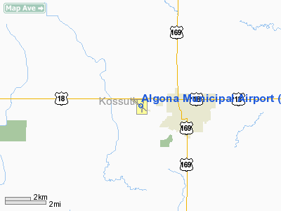
Algona Municipal Airport (IATA: AXG, ICAO: KAXA, FAA LID: AXA) is a public airport located two miles (3 km) west of the central business district of Algona, a city in Kossuth County, Iowa, United States. It is owned by the City of Algona.
Although most U.S. airports use the same three-letter location identifier for the FAA and IATA, Algona Municipal is assigned AXA by the FAA and AXG by the IATA (which assigned AXA to Wallblake Airport in Anguilla).
Facilities and aircraft
Algona Municipal Airport covers an area of 221 acres (89 ha) which contains two runways: 12/30 with a concrete pavement measuring 3,960 x 75 ft (1,207 x 23 m) and 18/36 with a turf surface measuring 2,880 x 160 ft (878 x 49 m). For the 12-month period ending November 28, 2005, the airport had 6,975 aircraft operations, an average of 19 per day, all of which were general aviation.
The above content comes from Wikipedia and is published under free licenses – click here to read more.
Location
& QuickFacts
|
FAA Information Effective: |
2007-07-05 |
|
Airport
Identifier: |
AXA |
|
Airport
Status: |
Operational |
|
Longitude/Latitude: |
094-16-19.1740W/43-04-40.4780N
-94.271993/43.077911 (Estimated) |
|
Elevation: |
1219 ft / 371.55 m (Surveyed) |
|
Land: |
221 acres |
|
From
nearest city: |
2 nautical miles W of Algona, IA |
|
Location: |
Kossuth County, IA |
|
Magnetic Variation: |
04E (1995) |
Owner
& Manager
|
Ownership: |
Publicly owned |
|
Owner: |
City Of Algona |
|
Address: |
112 West Call
Algona, IA 50511 |
|
Phone number: |
515-295-2411 |
|
Manager: |
Jim Kohlhaas |
|
Address: |
2907 Hwy 18 W
Algona, IA 50511 |
|
Phone number: |
515-295-7492 |
Airport
Operations and Facilities
|
Airport Use: |
Open to public |
|
Wind
indicator: |
Yes |
|
Segmented
Circle: |
No |
|
Control
Tower: |
No |
|
Lighting
Schedule: |
DUSK-DAWN
ACTVT MIRL RY 12/30 AND REIL/SAVASI RYS 12 AND 30 - CTAF. |
|
Beacon
Color: |
Clear-Green (lighted land airport) |
|
Landing
fee charge: |
No |
|
Sectional
chart: |
Omaha |
|
Region: |
ACE - Central |
|
Boundary
ARTCC: |
ZMP - Minneapolis |
|
Tie-in
FSS: |
FOD - Fort Dodge |
|
FSS
on Airport: |
No |
|
FSS
Phone: |
515-955-8114 |
|
FSS
Toll Free: |
1-800-WX-BRIEF |
|
NOTAMs
Facility: |
AXA (NOTAM-d service avaliable) |
|
Federal Agreements: |
NGPY |
Airport
Communications
|
CTAF: |
122.800 |
|
Unicom: |
122.800 |
Airport
Services
|
Fuel available: |
100LLA |
|
Airframe Repair: |
MAJOR |
|
Power Plant Repair: |
MAJOR |
|
Bottled
Oxygen: |
NONE |
|
Bulk
Oxygen: |
NONE |
|
Runway Information
Runway 12/30
|
Dimension: |
3960 x 75 ft / 1207.0 x 22.9 m |
|
Surface: |
CONC, Good Condition |
|
Weight
Limit: |
Single wheel: 30000 lbs.
Dual wheel: 48000 lbs. |
|
Edge
Lights: |
Medium |
|
|
Runway 12 |
Runway 30 |
|
Longitude: |
094-16-42.1550W |
094-16-02.2900W |
|
Latitude: |
43-04-53.5300N |
43-04-27.5430N |
|
Elevation: |
1215.00
ft |
1204.00
ft |
|
Alignment: |
127 |
127 |
|
Traffic
Pattern: |
Left |
Left |
|
Markings: |
Non-precision instrument, Good Condition |
Non-precision instrument, Good Condition |
|
VASI: |
2-box SAVASI on left side |
2-box SAVASI on right side |
|
Runway
End Identifier: |
Yes |
Yes |
|
Obstruction: |
22 ft road, 500.0 ft from runway, 285 ft left
of centerline, 13:1 slope to clear |
10 ft road, 320.0 ft from runway, 50 ft left
of centerline, 12:1 slope to clear |
|
Runway 18/36
|
Dimension: |
2880 x 160 ft / 877.8 x 48.8 m |
|
Surface: |
TURF, Fair Condition |
|
|
Runway 18 |
Runway 36 |
|
Longitude: |
094-16-11.8740W |
094-16-16.8740W |
|
Latitude: |
43-04-52.8780N |
43-04-27.8780N |
|
Traffic
Pattern: |
Left |
Left |
|
Obstruction: |
15 ft road, 340.0 ft from runway, 22:1 slope
to clear |
4 ft fence, 135.0 ft from runway, 33:1 slope
to clear
4' FENCE 135' FROM RWY END |
|
Radio Navigation
Aids
|
ID |
Type |
Name |
Ch |
Freq |
Var |
Dist |
|
AXA |
NDB |
Algona |
|
403.00 |
03E |
0.2 nm |
|
EGQ |
NDB |
Emmetsburg |
|
410.00 |
04E |
19.2 nm |
|
POH |
NDB |
Pocahontas |
|
428.00 |
06E |
25.9 nm |
|
PUF |
NDB |
Puff |
|
345.00 |
04E |
26.2 nm |
|
EAG |
NDB |
Eagle Grove |
|
302.00 |
03E |
27.3 nm |
|
FXY |
NDB |
Forest City |
|
359.00 |
05E |
30.1 nm |
|
CAV |
NDB |
Clarion |
|
387.00 |
03E |
30.1 nm |
|
SBU |
NDB |
Blue Earth |
|
332.00 |
04E |
32.1 nm |
|
LTU |
NDB |
Little Sioux |
|
326.00 |
05E |
37.9 nm |
|
EBS |
NDB |
Webster City |
|
323.00 |
03E |
42.2 nm |
|
MJQ |
NDB |
Jackson |
|
353.00 |
04E |
46.3 nm |
|
EST |
VOR |
Estherville |
|
110.40 |
07E |
28.7 nm |
|
FRM |
VOR/DME |
Fairmont |
039X |
110.20 |
07E |
34.8 nm |
|
SPW |
VOR/DME |
Spencer |
037X |
110.00 |
05E |
41.1 nm |
|
FOD |
VORTAC |
Fort Dodge |
082X |
113.50 |
07E |
28.1 nm |
|
MCW |
VORTAC |
Mason City |
096X |
114.90 |
06E |
41.4 nm |
Remarks
Based
Aircraft
|
Aircraft
based on field: |
24 |
|
Single
Engine Airplanes: |
21 |
|
Multi
Engine Airplanes: |
1 |
|
Ultralights: |
2 |
Operational Statistics
Time Period: 2004-11-29
- 2005-11-28
|
Aircraft
Operations: |
135/Week |
|
General
Aviation Local: |
28.3% |
|
General
Aviation Itinerant: |
71.7% |
Algona Municipal Airport
Address:
Kossuth County, IA
Tel:
515-295-2411, 515-295-7492
Images
and information placed above are from
http://www.airport-data.com/airport/AXA/
We
thank them for the data!
| General
Info |
| Country |
United
States |
| State |
IOWA
|
| FAA ID |
AXA
|
| Latitude |
43-04-40.478N
|
| Longitude |
094-16-19.174W
|
| Elevation |
1219 feet
|
| Near City |
ALGONA
|
We don't guarantee the information is fresh and accurate. The data may
be wrong or outdated.
For more up-to-date information please refer to other sources.
|
|


