 |
|
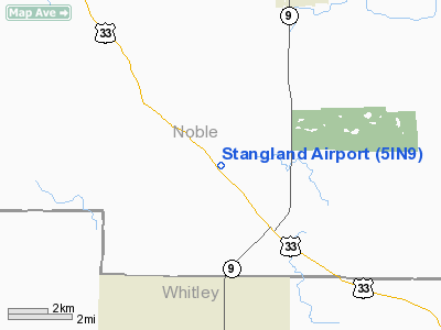
Location & QuickFacts
|
FAA
Information Effective: |
2008-06-05 |
|
Airport
Identifier: |
5IN9 |
| Airport
Status: |
Operational |
|
Longitude/Latitude: |
085-27-53.9290W/41-18-58.1710N
-85.464980/41.316159 (Estimated) |
|
Elevation: |
924
ft / 281.64 m (Estimated) |
|
Land: |
0 acres |
| From
nearest city: |
2
nautical miles SE of Wolflake, IN |
|
Location: |
Noble County, IN |
|
Magnetic Variation: |
03W
(1985) |
Owner
& Manager
|
Ownership: |
Privately
owned |
|
Owner: |
Don
H. Stangland |
|
Address: |
1838 West 250 South
Albion, IN 46701 |
|
Phone number: |
219-636-7532 |
|
Address: |
|
Airport
Operations and Facilities
|
Airport Use: |
Private |
|
Wind indicator: |
Yes |
|
Segmented Circle: |
No |
|
Control
Tower: |
No |
|
Landing fee charge: |
No |
|
Sectional
chart: |
Chicago |
|
Region: |
AGL
- Great Lakes |
|
Boundary
ARTCC: |
ZAU - Chicago |
|
Tie-in FSS: |
HUF
- Terre Haute |
|
FSS on
Airport: |
No |
|
FSS Toll Free: |
1-800-WX-BRIEF |
Airport
Services
|
Airframe
Repair: |
NONE |
|
Power
Plant Repair: |
NONE |
|
Bottled
Oxygen: |
NONE |
| Bulk
Oxygen: |
NONE |
|
Runway Information
Runway 09/27
|
Dimension: |
1900 x 80 ft
/ 579.1 x 24.4 m |
| Surface: |
TURF,
|
|
|
Runway 09 |
Runway 27 |
|
Traffic Pattern: |
Left |
Left |
| Runway
End Identifier: |
No |
No |
|
Centerline
Lights: |
No |
No |
| Touchdown
Lights: |
No |
No |
|
Radio Navigation Aids
|
ID |
Type |
Name |
Ch |
Freq |
Var |
Dist |
| ANQ |
NDB |
Angola |
|
347.00 |
05W |
25.9
nm |
|
HHG |
NDB |
Huntington |
|
417.00 |
03W |
27.7 nm |
| IRS |
NDB |
Sturgis |
|
382.00 |
04W |
29.9
nm |
|
RCR |
NDB |
Rochester |
|
216.00 |
03W |
36.1 nm |
| IWH |
NDB |
Wabash |
|
329.00 |
03W |
36.5
nm |
|
HAI |
NDB |
Three Rivers |
|
407.00 |
02W |
39.0 nm |
| CPB |
NDB |
Culver |
|
391.00 |
01W |
42.0
nm |
|
BYN |
NDB |
Bryan |
|
260.00 |
04W |
46.1 nm |
| DFI |
NDB |
Defiance |
|
246.00 |
05W |
46.9
nm |
|
VFU |
NDB |
Stanley |
|
411.00 |
05W |
47.2 nm |
| OLK |
VOR |
Wolf
Lake |
|
110.40 |
03W |
4.4
nm |
|
FWA |
VORTAC |
Fort Wayne |
125X |
117.80 |
00E |
23.8 nm |
| GSH |
VORTAC |
Goshen |
084X |
113.70 |
00E |
28.3
nm |
|
GIJ |
VORTAC |
Gipper |
101X |
115.40 |
00E |
47.1 nm |
| FWA |
VOT |
Fort
Wayne Baer |
|
111.00 |
|
23.8
nm |
Remarks
Based Aircraft
|
Aircraft
based on field: |
1 |
|
Single Engine Airplanes: |
1 |
Operational Statistics
|
Aircraft
Operations: |
20/Week |
|
General Aviation
Local: |
85.2% |
| General
Aviation Itinerant: |
14.8% |
Stangland Airport
Address:
Noble County, IN
Tel:
219-636-7532
Images
and information placed above are from
http://www.airport-data.com/airport/5IN9/
We
thank them for the data!
| General
Info |
| Country |
United
States |
| State |
INDIANA
|
| FAA ID |
5IN9 |
| Latitude |
41-18-58.171N
|
| Longitude |
085-27-53.929W
|
| Elevation |
924 feet
|
| Near City |
WOLFLAKE
|
We don't guarantee the information is fresh and accurate. The data may
be wrong or outdated.
For more up-to-date information please refer to other sources.
|
|


