 |
|
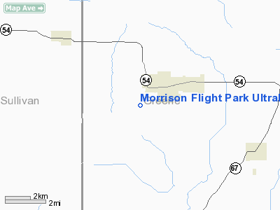
Morrison Flight Park Ultralight |
Location
& QuickFacts
|
FAA
Information Effective: |
2008-06-05 |
|
Airport
Identifier: |
4U8 |
|
Airport
Status: |
Operational |
|
Longitude/Latitude: |
087-11-13.4000W/39-01-18.2000N
-87.187056/39.021722 (Estimated) |
|
Elevation: |
520 ft / 158.50 m (Estimated) |
|
Land: |
0 acres |
|
From nearest
city: |
2 nautical miles SW of Linton, IN |
|
Location: |
Greene County, IN |
|
Magnetic
Variation: |
02W (1995) |
Owner & Manager
|
Ownership: |
Privately
owned |
|
Owner: |
Lester W. Morrison |
|
Address: |
Rr 2 Box 1084
Linton, IN 04741 |
|
Phone
number: |
812-847-2321 |
|
Manager: |
Lester W. Morrison |
|
Address: |
Rr 2 Box 1084
Linton, IN 47441 |
|
Phone
number: |
812-847-2321 |
Airport
Operations and Facilities
|
Airport
Use: |
Open
to public |
|
Wind indicator: |
Yes |
|
Segmented
Circle: |
No |
|
Control
Tower: |
No |
|
Sectional
chart: |
St Louis |
|
Region: |
AGL - Great Lakes |
|
Boundary
ARTCC: |
ZID - Indianapolis |
|
Tie-in
FSS: |
HUF - Terre Haute |
|
FSS Toll
Free: |
1-800-WX-BRIEF |
|
NOTAMs
Facility: |
HUF (NOTAM-d service avaliable) |
Airport
Communications
|
Runway Information
Runway 18U/36U
|
Dimension: |
1225 x 70 ft
/ 373.4 x 21.3 m |
|
Surface: |
TURF, Good Condition |
|
|
Runway 18U |
Runway 36U |
|
Longitude: |
087-11-13.6400W |
087-11-13.2300W |
|
Latitude: |
39-01-24.2400N |
39-01-12.1300N |
|
Traffic
Pattern: |
Left |
Left |
|
Displaced
threshold: |
0.00 ft |
225.00 ft
RY 36 DSPLCD THLD MKD WITH 2 YELLOW TIRES ON EACH SIDE OF
RY. |
|
Obstruction: |
|
15 ft road, 10.0 ft from runway
RWY 36U APP SLOPE TO DSPLCD T-HOLD 15:1. |
|
Radio Navigation
Aids
|
ID |
Type |
Name |
Ch |
Freq |
Var |
Dist |
|
SIV |
NDB |
Sullivan |
|
326.00 |
02W |
13.3 nm |
|
DCY |
NDB |
Washington |
|
212.00 |
03W |
19.7 nm |
|
PLX |
NDB |
Palestine |
|
391.00 |
00W |
21.2 nm |
|
HU |
NDB |
Yinno |
|
245.00 |
02W |
24.1 nm |
|
OEA |
NDB |
Vincennes |
|
251.00 |
00E |
26.3 nm |
|
BM |
NDB |
Claye |
|
382.00 |
02W |
27.5 nm |
|
AJG |
NDB |
Mount Carmel |
|
524.00 |
02W |
35.3 nm |
|
BFR |
NDB |
Bedford |
|
344.00 |
02W |
36.8 nm |
|
CZB |
NDB |
Casey |
|
359.00 |
00E |
41.6 nm |
|
RRJ |
NDB |
Oranj |
|
368.00 |
02W |
42.8 nm |
|
TVX |
NDB |
Greencastle |
|
521.00 |
03W |
45.2 nm |
|
PRG |
NDB |
Paris |
|
341.00 |
01E |
46.5 nm |
|
FNZ |
NDB |
Ferdinand |
|
239.00 |
00E |
49.3 nm |
|
OLY |
NDB |
Olney |
|
272.00 |
00W |
49.6 nm |
|
RSV |
VOR/DME |
Robinson |
021X |
108.40 |
02E |
21.6 nm |
|
LWV |
VOR/DME |
Lawrenceville |
025X |
108.80 |
01W |
24.7 nm |
|
HNB |
VOR/DME |
Huntingburg |
029X |
109.20 |
00E |
47.6 nm |
|
OOM |
VORTAC |
Hoosier |
039X |
110.20 |
02W |
27.8 nm |
|
TTH |
VORTAC |
Terre Haute |
100X |
115.30 |
02E |
28.2 nm |
Remarks
- 400
FT TOWER 900 FT NW OF RY 36 & 390 FT TOWER 1/2 MILE ENE OF RY 36.
- PRVDD
15:1 CLEAR APCH OVR THE OBSTN, CLEAR RY SAFETY AREA, DSPLCD THLD RY
36 PROPERLY MKD, RIGHT TFC RY 18 INDICATED BY A SEGMENTED CIRCLE &
PUBLISHED IN THE AFD.
Based Aircraft
|
Aircraft
based on field: |
4 |
|
Ultralights: |
4 |
Operational Statistics
Time
Period: 2003-01-01 - 2003-12-31
|
Aircraft
Operations: |
35/Month |
|
General Aviation
Local: |
90.0% |
|
General Aviation
Itinerant: |
10.0% |
Morrison Flight Park Ultralight
Address:
Greene County, IN
Tel:
812-847-2321
Images
and information placed above are from
http://www.airport-data.com/airport/4U8/
We
thank them for the data!
| General
Info |
| Country |
United
States |
| State |
INDIANA
|
| FAA ID |
4U8 |
| Latitude |
39-01-20.000N
|
| Longitude |
087-11-15.000W
|
| Elevation |
520 feet
|
| Near City |
LINTON
|
We don't guarantee the information is fresh and accurate. The data may
be wrong or outdated.
For more up-to-date information please refer to other sources.
|
|


