 |
|
|
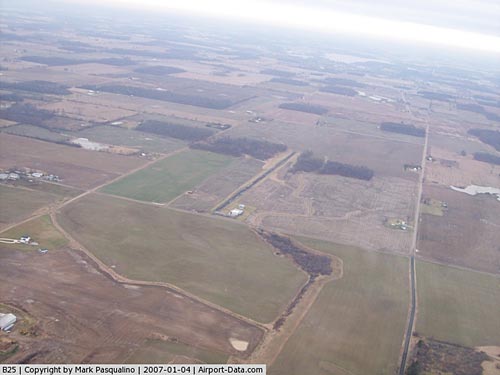 |
(Click on the photo to enlarge) |
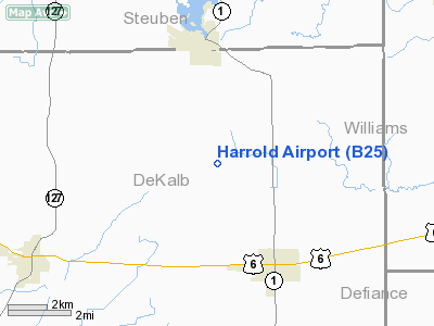
Location
& QuickFacts
|
FAA
Information Effective: |
2008-06-05 |
|
Airport
Identifier: |
B25 |
|
Airport
Status: |
Operational |
|
Longitude/Latitude: |
084-54-21.8630W/41-28-34.1810N
-84.906073/41.476161 (Estimated) |
|
Elevation: |
925 ft / 281.94 m (Estimated) |
|
Land: |
10 acres |
|
From nearest
city: |
3 nautical miles NW of Butler, IN |
|
Location: |
De Kalb County, IN |
|
Magnetic
Variation: |
04W (1985) |
Owner
& Manager
|
Ownership: |
Privately
owned |
|
Owner: |
Robert K. Harrold
AIRCRAFT MAINTENANCE INC. |
|
Address: |
6091 Cr16, Po Box 411
Butler, IN 46721 |
|
Phone
number: |
260-868-5493 |
|
Manager: |
Robert K. Harrold |
|
Address: |
6091 Cr16; P.o. Box 411
Butler, IN 46721 |
|
Phone
number: |
260-868-5493 |
Airport
Operations and Facilities
|
Airport
Use: |
Open
to public |
|
Segmented
Circle: |
Yes |
|
Control
Tower: |
No |
|
Landing
fee charge: |
No |
|
Sectional
chart: |
Detroit |
|
Region: |
AGL - Great Lakes |
|
Boundary
ARTCC: |
ZOB - Cleveland |
|
Tie-in
FSS: |
HUF - Terre Haute |
|
FSS on
Airport: |
No |
|
FSS Toll
Free: |
1-800-WX-BRIEF |
|
NOTAMs
Facility: |
HUF (NOTAM-d service avaliable) |
Airport
Communications
Airport
Services
|
Airframe
Repair: |
MAJOR |
|
Power
Plant Repair: |
MAJOR |
|
Runway Information
Runway 18/36
|
Dimension: |
2920 x 46 ft
/ 890.0 x 14.0 m |
|
Surface: |
GRVL, Fair Condition |
|
|
Runway 18 |
Runway 36 |
|
Longitude: |
084-54-22.8600W |
084-54-22.8600W |
|
Latitude: |
41-28-48.4900N |
41-28-17.8700N |
|
Elevation: |
910.00 ft |
910.00 ft |
|
Traffic
Pattern: |
Left |
Left |
|
Displaced
threshold: |
200.00 ft |
400.00 ft |
|
Obstruction: |
10 ft crops, 20.0 ft from runway, 2:1 slope
to clear
RY 18 APCH RATIO 22:1 TO DSPLCD THLD; CROPS. |
15 ft road, 150.0 ft from runway, 10:1 slope
to clear
RY 36 APCH RATIO 36:1 TO DSPLCD THLD; ROAD. |
|
Radio Navigation
Aids
|
ID |
Type |
Name |
Ch |
Freq |
Var |
Dist |
|
ANQ |
NDB |
Angola |
|
347.00 |
05W |
12.8 nm |
|
BYN |
NDB |
Bryan |
|
260.00 |
04W |
19.8 nm |
|
DFI |
NDB |
Defiance |
|
246.00 |
05W |
23.2 nm |
|
IRS |
NDB |
Sturgis |
|
382.00 |
04W |
31.2 nm |
|
USE |
NDB |
Fulton |
|
375.00 |
05W |
35.7 nm |
|
VFU |
NDB |
Stanley |
|
411.00 |
05W |
39.2 nm |
|
HAI |
NDB |
Three Rivers |
|
407.00 |
02W |
42.3 nm |
|
ADG |
NDB |
Adrian |
|
278.00 |
06W |
44.1 nm |
|
HHG |
NDB |
Huntington |
|
417.00 |
03W |
45.0 nm |
|
PDR |
NDB |
Ottawa |
|
233.00 |
05W |
49.8 nm |
|
OLK |
VOR |
Wolf Lake |
|
110.40 |
03W |
30.0 nm |
|
LFD |
VOR/DME |
Litchfield |
049X |
111.20 |
05W |
35.8 nm |
|
FWA |
VORTAC |
Fort Wayne |
125X |
117.80 |
00E |
32.5 nm |
|
FWA |
VOT |
Fort Wayne Baer |
|
111.00 |
|
32.6 nm |
Remarks
- DEER
& BIRDS ON & INVOF RY.
- OBSTNS
IN APCH REMOVED/LWRD OR THR DSPLCD/MKD TO PRVD MIN 20:1 APCH CLNC; TFC
FLOWN E OF N/S RY; RY 36 RP; TFC PAT INDCR INSTLD; AND REF TO AC 150/5300-4B
IS ESTABD TO PRVD AN ACTBL LEVEL OF SAFETY FOR ACFT OPNS.
Based Aircraft
|
Aircraft
based on field: |
2 |
|
Single Engine
Airplanes: |
2 |
Operational Statistics
Time
Period: 2006-01-01 - 2006-12-31
|
Aircraft
Operations: |
17/Week |
|
General Aviation
Local: |
50.0% |
|
General Aviation
Itinerant: |
50.0% |
Harrold Airport
Address:
De Kalb County, IN
Tel:
260-868-5493
Images
and information placed above are from
http://www.airport-data.com/airport/B25/
We
thank them for the data!
| General
Info |
| Country |
United
States |
| State |
INDIANA
|
| FAA ID |
B25 |
| Latitude |
41-28-34.181N
|
| Longitude |
084-54-21.863W
|
| Elevation |
925 feet
|
| Near City |
BUTLER
|
We don't guarantee the information is fresh and accurate. The data may
be wrong or outdated.
For more up-to-date information please refer to other sources.
|
|


