 |
|
|
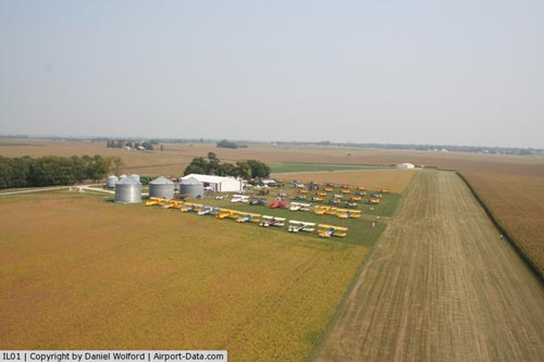 |
(Click on the photo to enlarge) |
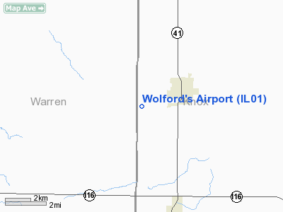
Location
& QuickFacts
|
FAA
Information Effective: |
2007-12-20 |
|
Airport
Identifier: |
IL01 |
|
Airport
Status: |
Operational |
|
Longitude/Latitude: |
090-26-17.4660W/40-47-33.1400N
-90.438185/40.792539 (Estimated) |
|
Elevation: |
720 ft / 219.46 m (Surveyed) |
|
Land: |
0 acres |
|
From nearest
city: |
2 nautical miles SW of Abingdon, IL |
|
Location: |
Knox County, IL |
|
Magnetic
Variation: |
02E (1985) |
Owner & Manager
|
Ownership: |
Privately
owned |
|
Owner: |
Arthur T. Wolford |
|
Address: |
Rr 3
Abingdon, IL 61410 |
|
Phone
number: |
309-462-2288 |
|
Address: |
|
|
Phone
number: |
309-462-2288 |
Airport Operations
and Facilities
|
Airport Use: |
Private |
|
Wind
indicator: |
Yes |
|
Segmented
Circle: |
No |
|
Control
Tower: |
No |
|
Sectional
chart: |
Chicago |
|
Region: |
AGL - Great Lakes |
|
Boundary
ARTCC: |
ZAU - Chicago |
|
Tie-in
FSS: |
IKK - Kankakee |
|
FSS on
Airport: |
No |
|
FSS Toll
Free: |
1-800-WX-BRIEF |
Airport Services
|
Fuel
available: |
80 |
|
Airframe
Repair: |
NONE |
|
Power
Plant Repair: |
NONE |
|
Runway Information
Runway 06/24
|
Dimension: |
2600 x 100 ft
/ 792.5 x 30.5 m |
|
Surface: |
TURF, |
|
|
Runway 06 |
Runway 24 |
|
Traffic
Pattern: |
Left |
Left |
|
Helipad H1
|
Dimension: |
50 x 50 ft /
15.2 x 15.2 m |
|
Surface: |
TURF, |
|
|
Runway H1 |
Runway |
|
Traffic
Pattern: |
Left |
Left |
|
Radio Navigation
Aids
|
ID |
Type |
Name |
Ch |
Freq |
Var |
Dist |
|
JZY |
NDB |
Macomb |
|
251.00 |
01E |
17.4 nm |
|
CTK |
NDB |
Canton |
|
236.00 |
02E |
21.4 nm |
|
EZI |
NDB |
Kewanee |
|
245.00 |
01E |
32.8 nm |
|
PI |
NDB |
Tungg |
|
356.00 |
01E |
40.1 nm |
|
EOK |
NDB |
Keokuk |
|
366.00 |
02E |
49.5 nm |
|
MPZ |
NDB |
Mount Pleasant |
|
212.00 |
02E |
49.5 nm |
|
GBG |
VOR/DME |
Galesburg |
035X |
109.80 |
03E |
8.7 nm |
|
DDD |
VOR/DME |
Port City |
112X |
116.50 |
01E |
47.2 nm |
|
BRL |
VORTAC |
Burlington |
051X |
111.40 |
05E |
22.6 nm |
|
PIA |
VORTAC |
Peoria |
099X |
115.20 |
04E |
30.2 nm |
|
MZV |
VORTAC |
Moline |
091X |
114.40 |
05E |
33.0 nm |
|
BDF |
VORTAC |
Bradford |
094X |
114.70 |
00E |
44.5 nm |
|
DVN |
VOT |
Davenport Municipal |
|
111.80 |
|
49.7 nm |
Remarks
- PRVDD
ALL ACFT OPNS ARE CONDD SE OF NE/SE RWY. HELI CONDS: PRVDD ALL OPNS
ARE TO/FM NORTH, SOUTH & EAST.
Based Aircraft
|
Aircraft
based on field: |
1 |
|
Single Engine
Airplanes: |
1 |
Wolford's Airport
Address:
Knox County, IL
Tel:
309-462-2288
Images
and information placed above are from
http://www.airport-data.com/airport/IL01/
We
thank them for the data!
| General
Info |
| Country |
United
States |
| State |
ILLINOIS
|
| FAA ID |
IL01 |
| Latitude |
40-47-33.140N
|
| Longitude |
090-26-17.466W
|
| Elevation |
720 feet
|
| Near City |
ABINGDON
|
We don't guarantee the information is fresh and accurate. The data may
be wrong or outdated.
For more up-to-date information please refer to other sources.
|
|


