|
|
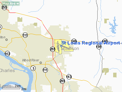
St Louis Regional Airport |
History
The airport was known as Civic Memorial Airport when it opened in 1946 and received its current name in 1984.
In the spring of 2004, the airport was at the center of scandal when its recently-retired manager Marion Richardson and other current and former employees were investigated for suspicion of misappropriation of airport property.
Facilities and aircraft
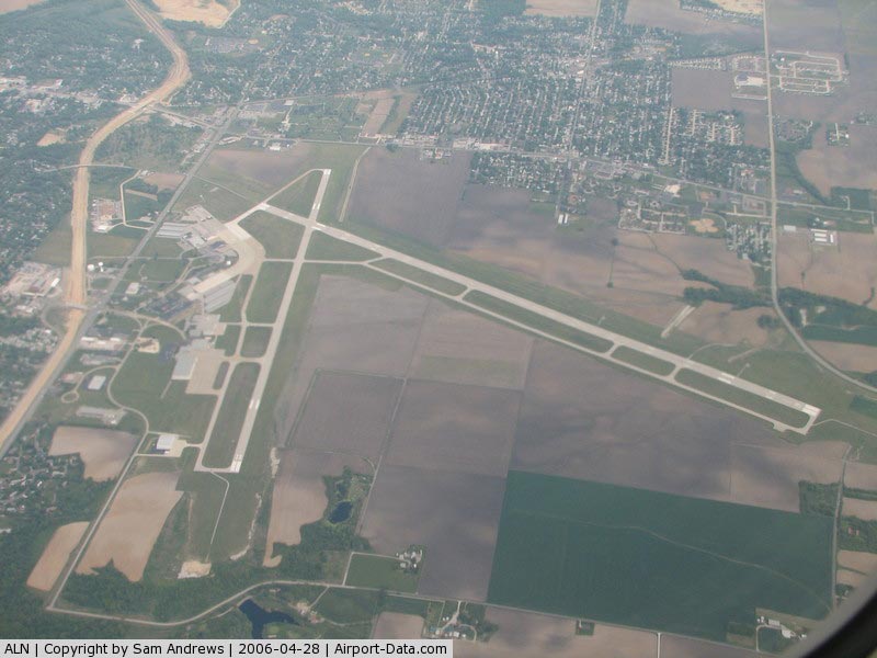
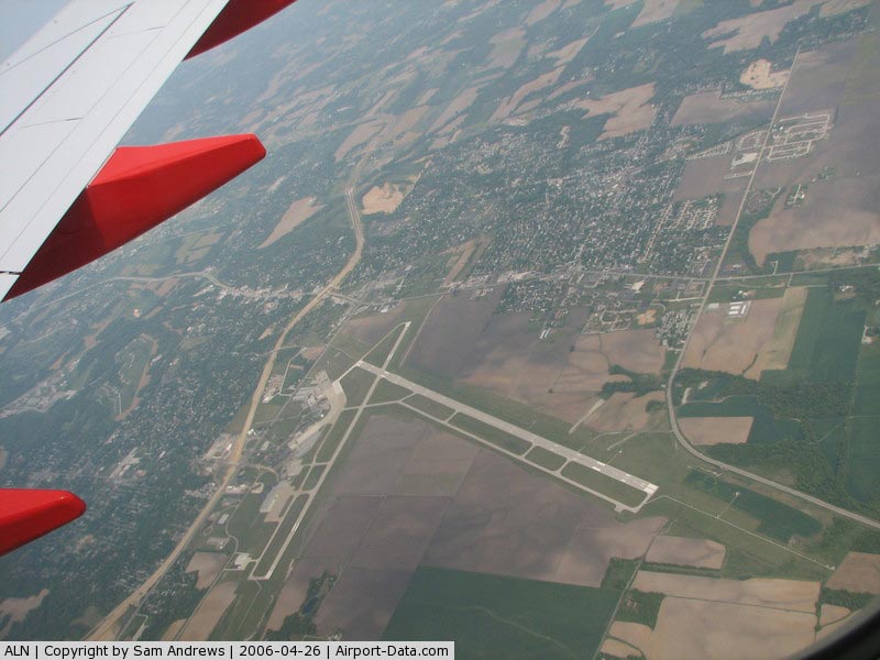
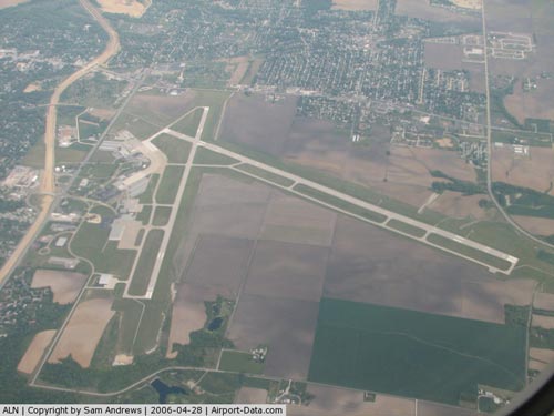
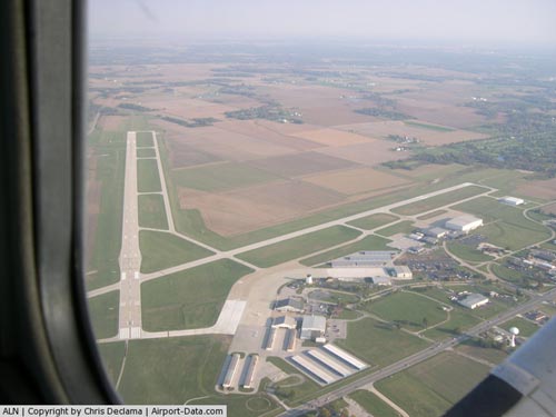
The 2,250 acres (911 ha) airfield sits at 544 ft (166 m) MSL. It has an 8100 by 150 ft (2469 by 46 m) primary runway that runs roughly east-west (11/29) and a 6500 by 100 ft (1981 by 30 m) crosswind runway that runs north-south (17/35). With an ILS instrument approach and tower-controlled class D airspace, the facility can accommodate aircraft as large as a Boeing 747.
For the 12-month period ending December 31, 2006, the airport had 42,537 aircraft operations, an average of 116 per day: 93% general aviation, 4% air taxi, 3% military and <1% scheduled commercial. At that time there were 102 aircraft based at this airport: 91% single-engine, 6% multi-engine, 2% jet and 1% helicopter.
The above content comes from Wikipedia and is published under free licenses – click here to read more.
|
 |
(Click on the photo to enlarge) |
|
 |
(Click on the photo to enlarge) |
|
 |
(Click on the photo to enlarge) |
Location
& QuickFacts
|
FAA
Information Effective: |
2007-12-20 |
|
Airport
Identifier: |
ALN |
|
Airport
Status: |
Operational |
|
Longitude/Latitude: |
090-02-45.7550W/38-53-25.0470N
-90.046043/38.890291 (Estimated) |
|
Elevation: |
544 ft / 165.81 m (Surveyed) |
|
Land: |
2250 acres |
|
From nearest
city: |
4 nautical miles E of Alton/st Louis, IL |
|
Location: |
Madison County, IL |
|
Magnetic
Variation: |
02E (1985) |
Owner
& Manager
|
Ownership: |
Publicly
owned |
|
Owner: |
St. Louis Regional |
|
Address: |
8 Terminal Dr Suite 1
East Alton, IL 62024 |
|
Phone
number: |
618-259-2531 |
|
Manager: |
David Miller |
|
Address: |
8 Terminal Dr, Suite 1
East Alton, IL 62024 |
|
Phone
number: |
618-259-2531 |
Airport
Operations and Facilities
|
Airport
Use: |
Open
to public |
|
Wind indicator: |
Yes |
|
Segmented
Circle: |
No |
|
Control
Tower: |
Yes |
|
Lighting
Schedule: |
DUSK-DAWN
WHEN ATCT CLSD HIRL RY 11/29 & MIRL RY 17/35 PRESET
ON LOW INTST; TO INCR INTST & ACTVT MALSR RY 29 - CTAF. |
|
Beacon
Color: |
Clear-Green (lighted land airport) |
|
Landing
fee charge: |
No |
|
Sectional
chart: |
St Louis |
|
Region: |
AGL - Great Lakes |
|
Boundary
ARTCC: |
ZKC - Kansas City |
|
Tie-in
FSS: |
STL - Saint Louis |
|
FSS on
Airport: |
No |
|
FSS Toll
Free: |
1-800-WX-BRIEF |
|
NOTAMs
Facility: |
ALN (NOTAM-d service avaliable) |
|
Certification
type/date: |
IV A U 10/197
CLSD TO SCHEDULED ACR OPNS WITH GREATER THAN 9 PSGR SEATS
& UNSCHEDULED ACR OPNS GREATER THAN 30 PSGR SEATS. 90-DAY
PPR; CALL AMGR 618-259-2531. |
|
Federal
Agreements: |
NGY |
Airport
Communications
|
CTAF: |
126.000 |
|
Unicom: |
122.950
|
Airport
Services
|
Fuel
available: |
100LLA |
|
Airframe
Repair: |
MAJOR |
|
Power
Plant Repair: |
MAJOR |
|
Bottled
Oxygen: |
HIGH |
|
Bulk Oxygen: |
HIGH |
|
Runway Information
Runway 11/29
|
Dimension: |
8101 x 150 ft
/ 2469.2 x 45.7 m |
|
Surface: |
ASPH, Good Condition |
|
Surface Treatment: |
Saw-cut or plastic Grooved |
|
Weight Limit: |
Single wheel: 80000 lbs.
Dual wheel: 140000 lbs.
Dual tandem wheel: 200000 lbs. |
|
Edge Lights: |
High |
|
|
Runway 11 |
Runway 29 |
|
Longitude: |
090-03-17.8860W |
090-01-43.8260W |
|
Latitude: |
38-53-42.8810N |
38-53-11.1380N |
|
Elevation: |
538.00 ft |
527.00 ft |
|
Alignment: |
113 |
127 |
|
ILS Type: |
|
ILS/DME |
|
Traffic
Pattern: |
Left |
Left |
|
Markings: |
Precision instrument, Good Condition |
Precision instrument, Good Condition |
|
Crossing
Height: |
46.00 ft |
0.00 ft |
|
VASI: |
4-box on left side |
|
|
Visual Glide
Angle: |
3.00° |
0.00° |
|
Approach
lights: |
|
MALSR |
|
Runway End
Identifier: |
Yes |
No |
|
Centerline
Lights: |
No |
No |
|
Touchdown
Lights: |
No |
No |
|
Obstruction: |
24 ft hgr, 656.0 ft from runway, 509 ft right
of centerline, 19:1 slope to clear |
, 50:1 slope to clear |
|
Runway 17/35
|
Dimension: |
6500 x 100 ft
/ 1981.2 x 30.5 m |
|
Surface: |
ASPH, Good Condition |
|
Weight Limit: |
Single wheel: 35000 lbs.
Dual wheel: 47000 lbs. |
|
Edge Lights: |
Medium |
|
|
Runway 17 |
Runway 35 |
|
Longitude: |
090-03-09.0910W |
090-02-59.5680W |
|
Latitude: |
38-53-54.5050N |
38-52-50.6910N |
|
Elevation: |
533.00 ft |
543.00 ft |
|
Alignment: |
127 |
127 |
|
Traffic
Pattern: |
Left |
Left |
|
Markings: |
Non-precision instrument, Fair Condition |
Non-precision instrument, Fair Condition |
|
Crossing
Height: |
45.00 ft |
45.00 ft |
|
VASI: |
4-box on left side |
4-box on left side |
|
Visual Glide
Angle: |
3.00° |
3.00° |
|
Centerline
Lights: |
No |
No |
|
Touchdown
Lights: |
No |
No |
|
Obstruction: |
18 ft tree, 896.0 ft from runway, 139 ft left
of centerline, 38:1 slope to clear |
32 ft trees, 1379.0 ft from runway, 72 ft right
of centerline, 36:1 slope to clear |
|
Radio Navigation
Aids
|
ID |
Type |
Name |
Ch |
Freq |
Var |
Dist |
|
CVM |
NDB |
Civic Memorial |
|
263.00 |
02E |
0.5 nm |
|
LM |
NDB |
Oblio |
|
338.00 |
00E |
20.8 nm |
|
LTD |
NDB |
Litchfield |
|
371.00 |
01E |
23.9 nm |
|
BL |
NDB |
Belleville |
|
362.00 |
02E |
29.0 nm |
|
FES |
NDB |
Festus |
|
269.00 |
01E |
44.7 nm |
|
SAR |
NDB |
Sparta |
|
239.00 |
01E |
47.6 nm |
|
SKE |
TACAN |
Scott |
059X |
|
02E |
22.7 nm |
|
CSX |
VOR/DME |
Cardinal |
111Y |
116.45 |
00E |
16.9 nm |
|
TOY |
VORTAC |
Troy |
107X |
116.00 |
04E |
10.9 nm |
|
STL |
VORTAC |
St Louis |
121X |
117.40 |
01E |
20.5 nm |
|
VLA |
VORTAC |
Vandalia |
090X |
114.30 |
04E |
43.1 nm |
|
FTZ |
VORTAC |
Foristell |
045X |
110.80 |
05E |
44.9 nm |
|
STL |
VOT |
St Louis Lambert |
|
111.00 |
|
17.1 nm |
|
SUS |
VOT |
Spirit Of St Louis |
|
112.20 |
|
31.5 nm |
Remarks
- INDEX
E FIREFIGHTING EQUIP AVBL WITH 30-MIN NOTICE & PRIOR PERMISSION
OF AMGR.
Based Aircraft
|
Aircraft
based on field: |
102 |
|
Single Engine
Airplanes: |
93 |
|
Multi Engine Airplanes: |
6 |
|
Jet Engine Airplanes: |
2 |
|
Helicopters: |
1 |
Operational Statistics
Time
Period: 2006-01-01 - 2006-12-31
|
Aircraft
Operations: |
117/Day |
|
Commerical: |
0.0% |
|
Air Taxi: |
4.0% |
|
General Aviation
Local: |
26.3% |
|
General Aviation
Itinerant: |
66.8% |
|
Military: |
2.9% |
St Louis Regional Airport
Address:
Madison County, IL
Tel:
618-259-2531
Images
and information placed above are from
http://www.airport-data.com/airport/ALN/
We
thank them for the data!
| General
Info |
| Country |
United
States |
| State |
ILLINOIS
|
| FAA ID |
ALN |
| Latitude |
38-53-25.047N
|
| Longitude |
090-02-45.755W
|
| Elevation |
544 feet
|
| Near City |
ALTON/ST
LOUIS |
We don't guarantee the information is fresh and accurate. The data may
be wrong or outdated.
For more up-to-date information please refer to other sources.
|
|