 |
|
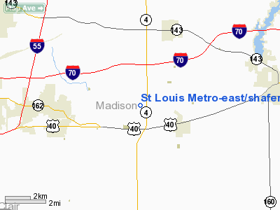
St Louis Metro-East / Shafer Field Airport |
St. Louis Metro-East Airport
Shafer Field |
| IATA: none – ICAO: none – FAA LID: 3K6 |
| Summary |
| Airport type |
Public-use |
| Owner |
Edward B. Shafer |
| Serves |
St. Jacob, Illinois |
| Elevation AMSL |
477 ft / 145 m |
| Coordinates |
38°43′58″N 089°48′24″W / 38.73278°N 89.80667°W / 38.73278; -89.80667 |
| Runways |
| Direction |
Length |
Surface |
| ft |
m |
| 13/31 |
2,662 |
811 |
Asphalt |
| Statistics (2007) |
| Aircraft operations |
52,000 |
| Based aircraft |
42 |
| Source: Federal Aviation Administration |
St. Louis Metro-East Airport (FAA LID: 3K6), also known as Shafer Field, is a public-use airport located two miles (3 km) north of the central business district of St. Jacob, in Madison County, Illinois, United States. It is privately owned by Edward B. Shafer.
Facilities and aircraft
St. Louis Metro-East Airport covers an area of 29 acres (12 ha) and contains one runway designated 13/31 with a 2,662 x 50 ft (811 x 15 m) asphalt surface. For the 12-month period ending August 31, 2007, the airport had 52,000 aircraft operations, an average of 142 per day: 98% general aviation and 2% air taxi. At that time there were 42 aircraft based at this airport: 95% single-engine, 2% glider and 2% ultralight.
The above content comes from Wikipedia and is published under free licenses – click here to read more.
|
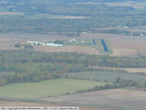 |
(Click on the photo to enlarge) |
|
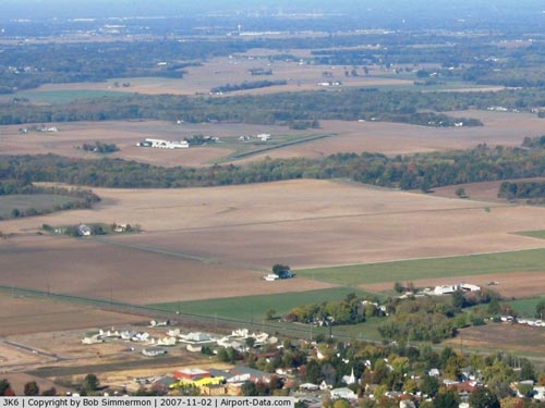 |
(Click on the photo to enlarge) |
|
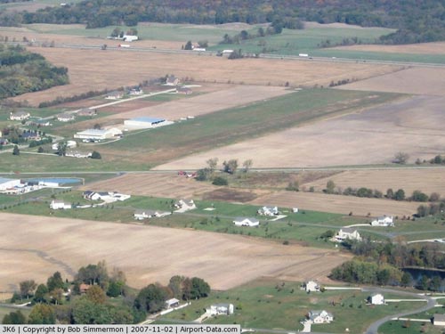 |
(Click on the photo to enlarge) |
Location
& QuickFacts
|
FAA
Information Effective: |
2007-12-20 |
|
Airport
Identifier: |
3K6 |
|
Airport
Status: |
Operational |
|
Longitude/Latitude: |
089-48-23.6420W/38-43-58.4710N
-89.806567/38.732909 (Estimated) |
|
Elevation: |
477 ft / 145.39 m (Surveyed) |
|
Land: |
29 acres |
|
From nearest
city: |
2 nautical miles N of St Jacob, IL |
|
Location: |
Madison County, IL |
|
Magnetic
Variation: |
01E (1985) |
Owner
& Manager
|
Ownership: |
Privately
owned |
|
Owner: |
Edward B. Shafer |
|
Address: |
2070 Triad Rd.
St Jacob, IL 62281 |
|
Phone
number: |
618-644-5411 |
|
Manager: |
Edward B. Shafer |
|
Address: |
2070 Triad Rd.
St Jacob, IL 62281 |
|
Phone
number: |
618-644-5411 |
Airport
Operations and Facilities
|
Airport
Use: |
Open
to public |
|
Wind indicator: |
Yes |
|
Segmented
Circle: |
No |
|
Control
Tower: |
No |
|
Lighting
Schedule: |
DUSK-DAWN
MIRL RY 13/31 PRESET ON LOW INTST; TO INCR INTST ACTVT -
CTAF. |
|
Beacon
Color: |
Clear-Green (lighted land airport) |
|
Landing
fee charge: |
No |
|
Sectional
chart: |
St Louis |
|
Region: |
AGL - Great Lakes |
|
Traffic
Pattern Alt: |
800 ft |
|
Boundary
ARTCC: |
ZKC - Kansas City |
|
Tie-in
FSS: |
STL - Saint Louis |
|
FSS on
Airport: |
No |
|
FSS Toll
Free: |
1-800-WX-BRIEF |
|
NOTAMs
Facility: |
STL (NOTAM-d service avaliable) |
|
Federal
Agreements: |
NMY |
Airport
Communications
|
CTAF: |
122.800 |
|
Unicom: |
122.800
|
Airport
Services
|
Fuel
available: |
100LL |
|
Airframe
Repair: |
MINOR |
|
Power
Plant Repair: |
MINOR |
|
Bottled
Oxygen: |
NONE |
|
Runway Information
Runway 13/31
|
Dimension: |
2662 x 50 ft
/ 811.4 x 15.2 m |
|
Surface: |
ASPH, Good Condition |
|
Edge Lights: |
Medium |
|
|
Runway 13 |
Runway 31 |
|
Longitude: |
089-48-35.1990W |
089-48-12.0490W |
|
Latitude: |
38-44-07.9650N |
38-43-48.9020N |
|
Elevation: |
477.00 ft |
469.00 ft |
|
Alignment: |
127 |
127 |
|
Traffic
Pattern: |
Left |
Left |
|
Markings: |
Basic, Good Condition |
Basic, Good Condition |
|
Displaced
threshold: |
127.00 ft |
0.00 ft |
|
Runway End
Identifier: |
No |
No |
|
Centerline
Lights: |
No |
No |
|
Touchdown
Lights: |
No |
No |
|
Obstruction: |
16 ft road, 210.0 ft from runway, 126 ft right
of centerline
APCH SLOPE IS 21:1 TO DSPLCD THLD. |
30 ft pole, 800.0 ft from runway, 30 ft left
of centerline, 20:1 slope to clear |
|
Radio Navigation
Aids
|
ID |
Type |
Name |
Ch |
Freq |
Var |
Dist |
|
CVM |
NDB |
Civic Memorial |
|
263.00 |
02E |
15.1 nm |
|
BL |
NDB |
Belleville |
|
362.00 |
02E |
16.3 nm |
|
LTD |
NDB |
Litchfield |
|
371.00 |
01E |
26.7 nm |
|
LM |
NDB |
Oblio |
|
338.00 |
00E |
31.6 nm |
|
SAR |
NDB |
Sparta |
|
239.00 |
01E |
35.7 nm |
|
SLO |
NDB |
Salem |
|
400.00 |
01W |
39.7 nm |
|
FES |
NDB |
Festus |
|
269.00 |
01E |
42.3 nm |
|
SKE |
TACAN |
Scott |
059X |
|
02E |
11.5 nm |
|
CSX |
VOR/DME |
Cardinal |
111Y |
116.45 |
00E |
26.0 nm |
|
TOY |
VORTAC |
Troy |
107X |
116.00 |
04E |
5.3 nm |
|
STL |
VORTAC |
St Louis |
121X |
117.40 |
01E |
32.6 nm |
|
ENL |
VORTAC |
Centralia |
097X |
115.00 |
04E |
35.8 nm |
|
VLA |
VORTAC |
Vandalia |
090X |
114.30 |
04E |
37.1 nm |
|
STL |
VOT |
St Louis Lambert |
|
111.00 |
|
26.1 nm |
|
SUS |
VOT |
Spirit Of St Louis |
|
112.20 |
|
39.9 nm |
Remarks
- MIL
HEL OPNS PRIOR PERMISSION ONLY.
- FOR
NOISE ABATEMENT PROCEDURES CTC AMGR 618-644-5411.
Based Aircraft
|
Aircraft
based on field: |
42 |
|
Single Engine
Airplanes: |
40 |
|
Gliders: |
1 |
|
Ultralights: |
1 |
Operational Statistics
Time
Period: 2006-09-01 - 2007-08-31
|
Aircraft
Operations: |
143/Day |
|
Air Taxi: |
1.9% |
|
General Aviation
Local: |
51.3% |
|
General Aviation
Itinerant: |
46.7% |
St Louis Metro-east/shafer Field Airport
Address:
Madison County, IL
Tel:
618-644-5411
Images
and information placed above are from
http://www.airport-data.com/airport/3K6/
We
thank them for the data!
| General
Info |
| Country |
United
States |
| State |
ILLINOIS
|
| FAA ID |
3K6 |
| Latitude |
38-43-58.471N
|
| Longitude |
089-48-23.642W
|
| Elevation |
477 feet
|
| Near City |
ST JACOB
|
We don't guarantee the information is fresh and accurate. The data may
be wrong or outdated.
For more up-to-date information please refer to other sources.
|
|


