|
|
St Louis Downtown Airport |
| St. Louis Downtown Airport |
 |
| IATA: CPS â ICAO: KCPS â FAA LID: CPS |
| Summary |
| Airport type |
Public |
| Owner |
Bi-State Development Agency |
| Serves |
Greater St. Louis |
| Location |
Cahokia, Illinois |
| Elevation AMSL |
413 ft / 126 m |
| Coordinates |
38°34â²15â³N 090°09â²22â³W / 38.57083°N 90.15611°W / 38.57083; -90.15611 |
| Website |
StLouisDowntownAirport.com |
| Runways |
| Direction |
Length |
Surface |
| ft |
m |
| 12R/30L |
6,997 |
2,133 |
Asphalt |
| 12L/30R |
3,800 |
1,158 |
Concrete |
| 5/23 |
2,799 |
853 |
Asphalt |
| Statistics (2005) |
| Aircraft operations |
170,000 |
| Based aircraft |
281 |
| Source: Federal Aviation Administration |
St. Louis Downtown Airport (IATA: CPS, ICAO: KCPS, FAA LID: CPS) is a public-use airport located in the St. Louis Metropolitan Area, one mile (2 km) east of the central business district of Cahokia, in St. Clair County, Illinois, United States. It is owned by the Bi-State Development Agency.
The St. Louis metropolitan area is also served by Lambert-St. Louis International Airport in St. Louis, Missouri; MidAmerica St. Louis Airport in Belleville, Illinois; St. Louis Regional Airport in Alton, Illinois; and Spirit of St. Louis Airport in Chesterfield, Missouri. Facilities and aircraft
St. Louis Downtown Airport covers an area of 940 acres (380 ha) which contains three paved runways: 12R/30L measuring 6,997 x 100 ft. (2,133 x 30 m), 12L/30R measuring 3,800 x 75 ft. (1,158 x 23 m) and 5/23 measuring 2,799 x 75 ft. (853 x 23 m).
For the 12-month period ending September 30, 2005, the airport had 170,000 aircraft operations, an average of 465 per day: 97% general aviation, 2% air taxi and 1% military. At that time there were 281 aircraft based at this airport: 62% single-engine, 21% multi-engine, 12% jet and 5% helicopter.
Historic Hanger #2 houses the Greater St. Louis Air & Space Museum.[1]
History
The airport opened in 1929 as Curtiss-Steinberg Airport. In 1940 it was renamed Curtiss-Parks Airport, followed by Parks Metropolitan Airport later that same year.
Taken over by the United States Army Air Force on 1 August 1939 as a basic (level 1) pilot training airfield. Assigned to USAAF Gulf Coast Training Center (later Central Flying Training Command). Parks Air College conducted contract basic flying training. Flying training was performed with Fairchild PT-19s as the primary trainer. Also had several PT-17 Stearmans and a few P-40 Warhawks assigned. Inactivated 12 March 1944 with the drawdown of AAFTC's pilot training program.
The airport closed in 1959 and reopened six years later as Bi-State Parks Airport. It was renamed St. Louis Downtown-Parks Airport in 1984 and received its current name in 1999.
The above content comes from Wikipedia and is published under free licenses – click here to read more.
|
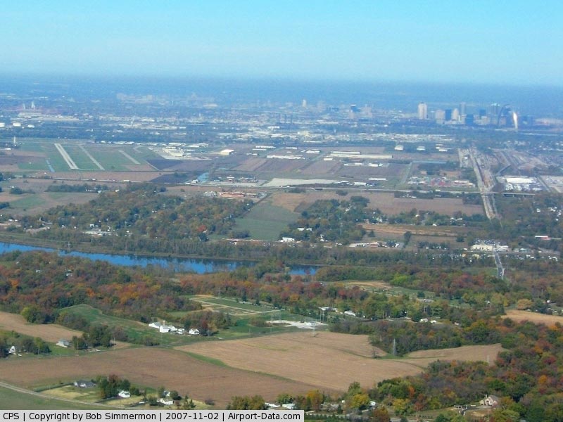
 |
(Click on the photo to enlarge) |
|
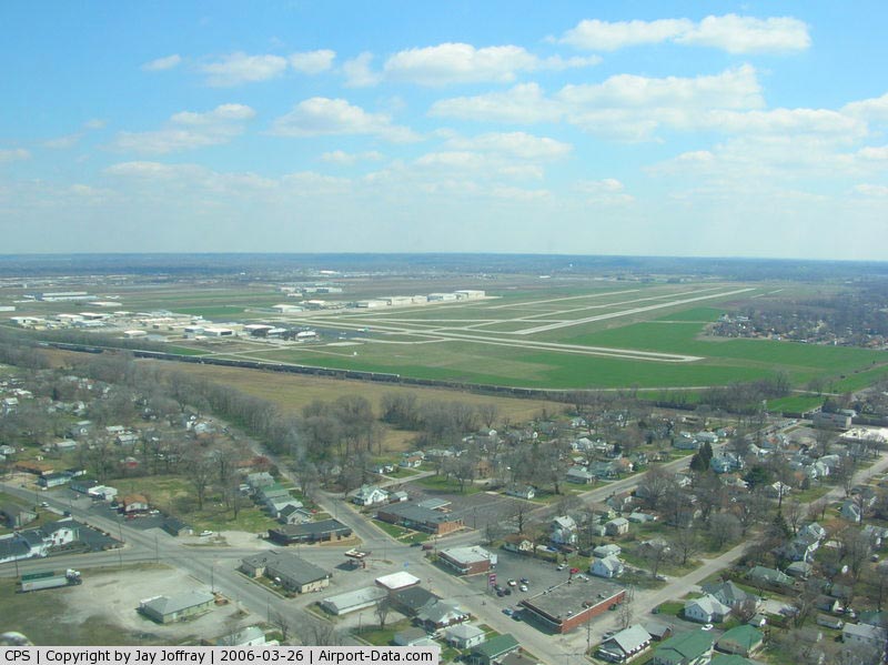
 |
(Click on the photo to enlarge) |
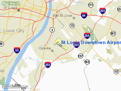
Location
& QuickFacts
|
FAA
Information Effective: |
2007-12-20 |
|
Airport
Identifier: |
CPS |
|
Airport
Status: |
Operational |
|
Longitude/Latitude: |
090-09-22.3960W/38-34-14.6080N
-90.156221/38.570724 (Estimated) |
|
Elevation: |
413 ft / 125.88 m (Surveyed) |
|
Land: |
940 acres |
|
From nearest
city: |
1 nautical miles E of Cahokia/st Louis, IL |
|
Location: |
St Clair County, IL |
|
Magnetic
Variation: |
00E (2000) |
Owner
& Manager
|
Ownership: |
Publicly
owned |
|
Owner: |
Bi-state Development Agency |
|
Address: |
707 N First St
St Louis, MO 63102-2595 |
|
Phone
number: |
314-982-1588 |
|
Manager: |
Robert L. Mcdaniel |
|
Address: |
1680 Sauget Industrial Parkway
Cahokia, IL 62206 |
|
Phone
number: |
618-337-6060 |
Airport
Operations and Facilities
|
Airport
Use: |
Open
to public |
|
Wind indicator: |
Yes |
|
Segmented
Circle: |
No |
|
Control
Tower: |
Yes |
|
Lighting
Schedule: |
DUSK-DAWN
MIRL RY 12R/30L PRESET ON MED INTST WHEN ATCT CLSD, MIRL
RY 12L/30R NOT AVBL WHEN ATCT C LSD - ACTVT MALSR RY 30L
WHEN ATCT CLSD - CTAF. |
|
Beacon
Color: |
Clear-Green (lighted land airport) |
|
Landing
fee charge: |
No |
|
Sectional
chart: |
St Louis |
|
Region: |
AGL - Great Lakes |
|
Boundary
ARTCC: |
ZKC - Kansas City |
|
Tie-in
FSS: |
STL - Saint Louis |
|
FSS on
Airport: |
No |
|
FSS Toll
Free: |
1-800-WX-BRIEF |
|
NOTAMs
Facility: |
CPS (NOTAM-d service avaliable) |
|
Federal
Agreements: |
NGY |
Airport
Communications
|
CTAF: |
120.900 |
|
Unicom: |
122.950
|
Airport
Services
|
Fuel
available: |
100LLA |
|
Airframe
Repair: |
MAJOR |
|
Power
Plant Repair: |
MAJOR |
|
Bulk Oxygen: |
HIGH |
|
Runway Information
Runway 05/23
|
Dimension: |
2799 x 75 ft
/ 853.1 x 22.9 m |
|
Surface: |
ASPH, Good Condition |
|
Weight Limit: |
Single wheel: 12000 lbs. |
|
Edge Lights: |
Medium |
|
|
Runway 05 |
Runway 23 |
|
Longitude: |
090-10-06.7150W |
090-09-40.9570W |
|
Latitude: |
38-34-20.4840N |
38-34-39.3700N |
|
Elevation: |
410.00 ft |
409.00 ft |
|
Alignment: |
47 |
127 |
|
Traffic
Pattern: |
Left |
Left |
|
Markings: |
Basic, Good Condition |
Basic, Good Condition |
|
Runway End
Identifier: |
No |
No |
|
Centerline
Lights: |
No |
No |
|
Touchdown
Lights: |
No |
No |
|
Obstruction: |
58 ft tree, 839.0 ft from runway, 58 ft right
of centerline, 11:1 slope to clear |
72 ft tower, 1647.0 ft from runway, 16 ft right
of centerline, 20:1 slope to clear |
|
Runway 12L/30R
|
Dimension: |
3800 x 75 ft
/ 1158.2 x 22.9 m |
|
Surface: |
CONC, Good Condition |
|
Weight Limit: |
Single wheel: 30000 lbs.
Dual wheel: 30000 lbs. |
|
Edge Lights: |
Medium |
|
|
Runway 12L |
Runway 30R |
|
Longitude: |
090-09-29.5610W |
090-08-49.0790W |
|
Latitude: |
38-34-25.5930N |
38-34-05.5710N |
|
Elevation: |
410.00 ft |
407.00 ft |
|
Alignment: |
122 |
127 |
|
Traffic
Pattern: |
Left |
Right |
|
Markings: |
Basic, Fair Condition |
Basic, Fair Condition |
|
Runway End
Identifier: |
Yes |
Yes |
|
Obstruction: |
96 ft tree, 3817.0 ft from runway, 254 ft left
of centerline, 37:1 slope to clear |
72 ft tree, 2664.0 ft from runway, 306 ft right
of centerline, 34:1 slope to clear |
|
Runway 12R/30L
|
Dimension: |
6997 x 100 ft
/ 2132.7 x 30.5 m |
|
Surface: |
ASPH, Good Condition |
|
Weight Limit: |
Single wheel: 43000 lbs.
Dual wheel: 71000 lbs.
Dual tandem wheel: 100000 lbs. |
|
Edge Lights: |
Medium |
|
|
Runway 12R |
Runway 30L |
|
Longitude: |
090-09-54.1920W |
090-08-39.6550W |
|
Latitude: |
38-34-26.3850N |
38-33-49.5150N |
|
Elevation: |
413.00 ft |
408.00 ft |
|
Alignment: |
122 |
127 |
|
ILS Type: |
|
ILS |
|
Traffic
Pattern: |
Right |
Left |
|
Markings: |
Precision instrument, Good Condition |
Precision instrument, Good Condition |
|
Crossing
Height: |
50.00 ft |
50.00 ft |
|
VASI: |
4-box on right side
OTS INDEFLY. |
4-box on left side |
|
Visual Glide
Angle: |
3.00° |
3.00° |
|
Approach
lights: |
|
MALSR |
|
Runway End
Identifier: |
Yes |
No |
|
Centerline
Lights: |
No |
No |
|
Touchdown
Lights: |
No |
No |
|
Obstruction: |
30 ft tree, 809.0 ft from runway, 487 ft left
of centerline, 20:1 slope to clear |
29 ft pole, 1688.0 ft from runway, 362 ft left
of centerline, 36:1 slope to clear |
|
Radio Navigation
Aids
|
ID |
Type |
Name |
Ch |
Freq |
Var |
Dist |
|
BL |
NDB |
Belleville |
|
362.00 |
02E |
19.9 nm |
|
CVM |
NDB |
Civic Memorial |
|
263.00 |
02E |
19.9 nm |
|
LM |
NDB |
Oblio |
|
338.00 |
00E |
20.3 nm |
|
FES |
NDB |
Festus |
|
269.00 |
01E |
25.0 nm |
|
SAR |
NDB |
Sparta |
|
239.00 |
01E |
33.3 nm |
|
LTD |
NDB |
Litchfield |
|
371.00 |
01E |
42.2 nm |
|
SKE |
TACAN |
Scott |
059X |
|
02E |
14.4 nm |
|
CSX |
VOR/DME |
Cardinal |
111Y |
116.45 |
00E |
14.6 nm |
|
TOY |
VORTAC |
Troy |
107X |
116.00 |
04E |
15.1 nm |
|
STL |
VORTAC |
St Louis |
121X |
117.40 |
01E |
23.2 nm |
|
FTZ |
VORTAC |
Foristell |
045X |
110.80 |
05E |
39.0 nm |
|
ENL |
VORTAC |
Centralia |
097X |
115.00 |
04E |
47.8 nm |
|
STL |
VOT |
St Louis Lambert |
|
111.00 |
|
14.4 nm |
|
SUS |
VOT |
Spirit Of St Louis |
|
112.20 |
|
23.9 nm |
Remarks
- DEER
& MIGRATORY WATERFOWL ON & INVOF ARPT.
- DURG
DALGT HRS & WHEN ATCT CLSD RIGHT TFC RYS 12R & 30R .
- BE
ALERT; INTENSIVE STUDENT TRAINING, HELICOPTER OPERATIONS, AND FREQUENT
BLIMP OPERATIONS.
Based Aircraft
|
Aircraft
based on field: |
281 |
|
Single Engine
Airplanes: |
174 |
|
Multi Engine Airplanes: |
60 |
|
Jet Engine Airplanes: |
34 |
|
Helicopters: |
13 |
Operational Statistics
Time
Period: 2004-10-01 - 2005-09-30
|
Aircraft
Operations: |
466/Day |
|
Air Taxi: |
2.4% |
|
General Aviation
Local: |
52.9% |
|
General Aviation
Itinerant: |
44.1% |
|
Military: |
0.6% |
St Louis Downtown Airport
Address:
St Clair County, IL
Tel:
314-982-1588,
618-337-6060
Images
and information placed above are from
http://www.airport-data.com/airport/CPS/
We
thank them for the data!
| General
Info |
| Country |
United
States |
| State |
ILLINOIS
|
| FAA ID |
CPS |
| Latitude |
38-34-14.608N
|
| Longitude |
090-09-22.396W
|
| Elevation |
413 feet
|
| Near City |
CAHOKIA/ST
LOUIS |
We don't guarantee the information is fresh and accurate. The data may
be wrong or outdated.
For more up-to-date information please refer to other sources.
|
|