 |
|
St James Hospital And Health Centers Heliport |
|
|
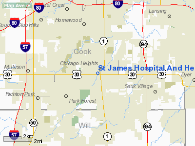
Location
& QuickFacts
|
FAA
Information Effective: |
2007-12-20 |
|
Airport
Identifier: |
9IS4 |
|
Airport
Status: |
Operational |
|
Longitude/Latitude: |
087-38-40.0000W/41-30-28.0000N
-87.644444/41.507778 (Estimated) |
|
Elevation: |
694 ft / 211.53 m (Estimated) |
|
Land: |
0 acres |
|
From nearest
city: |
1 nautical miles NW of Chicago Heights, IL |
|
Location: |
Cook County, IL |
|
Magnetic
Variation: |
01W (1985) |
Owner
& Manager
|
Ownership: |
Privately
owned |
|
Owner: |
Sisters Of St Francis |
|
Address: |
1515 Dragoon Trail, Box 1290
Mishawaka, IN 46544-9290 |
|
Phone
number: |
708-756-1000 |
|
Manager: |
John Guidotti |
|
Address: |
1423 Chicago Road
Chicago Heights, IL 60411-3483 |
|
Phone
number: |
708-756-1000 |
Airport
Operations and Facilities
|
Airport
Use: |
Private
MEDICAL USE. |
|
Wind indicator: |
Yes |
|
Segmented
Circle: |
No |
|
Control
Tower: |
No |
|
Lighting
Schedule: |
24 HRS |
|
Beacon
Color: |
Clear-Green-Yellow (heliport) |
|
Sectional
chart: |
Chicago |
|
Region: |
AGL - Great Lakes |
|
Boundary
ARTCC: |
ZAU - Chicago |
|
Tie-in
FSS: |
IKK - Kankakee |
|
FSS Toll
Free: |
1-800-WX-BRIEF |
|
Runway Information
Helipad H1
|
Dimension: |
40 x 40 ft /
12.2 x 12.2 m |
|
Surface: |
MATS,
STEEL MATS. ROOFTOP HELIPAD. |
|
|
Runway H1 |
Runway |
|
Traffic
Pattern: |
Left |
Left |
|
Radio Navigation
Aids
|
ID |
Type |
Name |
Ch |
Freq |
Var |
Dist |
|
MX |
NDB |
Kedzi |
|
248.00 |
01W |
14.2 nm |
|
HK |
NDB |
Ermin |
|
332.00 |
01W |
15.3 nm |
|
ME |
NDB |
Deana |
|
350.00 |
00E |
32.5 nm |
|
VP |
NDB |
Sedly |
|
212.00 |
02W |
34.7 nm |
|
MGC |
NDB |
Michigan City |
|
203.00 |
01W |
39.1 nm |
|
IUL |
NDB |
La Porte |
|
356.00 |
03W |
39.3 nm |
|
RZL |
NDB |
Rensselaer |
|
362.00 |
02W |
39.6 nm |
|
IKK |
VOR/DME |
Kankakee |
053X |
111.60 |
00E |
27.6 nm |
|
ORD |
VOR/DME |
Chicago O'hare |
086X |
113.90 |
02E |
31.1 nm |
|
DPA |
VOR/DME |
Dupage |
021X |
108.40 |
02E |
39.1 nm |
|
OBK |
VOR/DME |
Northbrook |
077X |
113.00 |
02W |
45.1 nm |
|
OXI |
VOR/DME |
Knox |
103X |
115.60 |
00E |
46.2 nm |
|
CGT |
VORTAC |
Chicago Heights |
089X |
114.20 |
02E |
3.3 nm |
|
EON |
VORTAC |
Peotone |
079X |
113.20 |
02E |
15.8 nm |
|
JOT |
VORTAC |
Joliet |
070X |
112.30 |
02E |
30.4 nm |
|
MDW |
VOT |
Chicago Midway |
|
111.00 |
|
17.4 nm |
|
ORD |
VOT |
Chicago O'hare Intl |
|
112.00 |
|
30.9 nm |
St James Hospital And Health Centers Heliport
Address:
Cook County, IL
Tel:
708-756-1000
Images
and information placed above are from
http://www.airport-data.com/airport/9IS4/
We
thank them for the data!
| General
Info |
| Country |
United
States |
| State |
ILLINOIS
|
| FAA ID |
9IS4 |
| Latitude |
41-30-28.000N
|
| Longitude |
087-38-40.000W
|
| Elevation |
694 feet
|
| Near City |
CHICAGO
HEIGHTS |
We don't guarantee the information is fresh and accurate. The data may
be wrong or outdated.
For more up-to-date information please refer to other sources.
|
|


