 |
|
Southern Illinois Airport |
| Southern Illinois Airport |
 |
 |
| FAA airport diagram |
| IATA: MDH â ICAO: KMDH â FAA LID: MDH |
| Summary |
| Airport type |
Public |
| Owner/Operator |
Southern Illinois Airport Authority |
| Serves |
Carbondale / Murphysboro, Illinois |
| Location |
Jackson County, Illinois |
| Elevation AMSL |
411 ft / 125 m |
| Coordinates |
37°46â²41â³N 089°15â²07â³W / 37.77806°N 89.25194°W / 37.77806; -89.25194 |
| Website |
www.SIAirport.com |
| Runways |
| Direction |
Length |
Surface |
| ft |
m |
| 6/24 |
4,164 |
1,269 |
Asphalt |
| 18L/36R |
6,506 |
1,983 |
Asphalt |
| 18R/36L |
3,498 |
1,066 |
Asphalt |
| Statistics (2009) |
| Aircraft operations |
77,557 |
| Based aircraft |
89 |
| Source: Federal Aviation Administration |
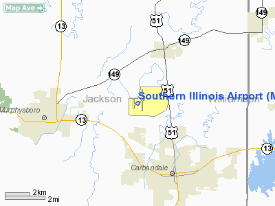
Southern Illinois Airport (IATA: MDH, ICAO: KMDH, FAA LID: MDH) is a public airport in Jackson County, Illinois, United States. It is located three nautical miles (6 km) northwest of the central business district of Carbondale and east of Murphysboro. This airport is included in the FAA's National Plan of Integrated Airport Systems for 2009â2013, which categorized it as a general aviation facility.
The airport opened in 1950 and was originally known as Murdale Airport. Today it ranks as the eighth busiest airport in the state.
The airport is owned and operated by Southern Illinois Airport Authority, a local governmental entity created under state law. A five member boards sets policy for the airport authority and daily administration of the airport is carried out by an airport manager and staff. The board members are appointed by the mayors of Carbondale and Murphysboro and the Chairman of the Jackson County Board and serve for five years on a staggered basis. Facilities and aircraft
Southern Illinois Airport covers an area of 850 acres (344 ha) at an elevation of 411 feet (125 m) above mean sea level. Three lighted, hard surface runways provide all-weather capability. A precision instrument approach is available on the airport's primary runway.
| Runway |
Dimensions |
Surface |
Status |
| 6/24 |
4,164 x 100 feet (1,269 x 30 m) |
Asphalt |
In-Use |
| 18L/36R |
6,506 x 100 feet (1,983 x 30 m) |
Asphalt |
In-Use |
| 18R/36L |
3,498 x 60 feet (1,066 x 18 m) |
Asphalt |
In-Use |
For the 12-month period ending December 31, 2009, the airport had 77,557 aircraft operations, an average of 212 per day: 99% general aviation, 1% air taxi, <1% scheduled commercial, and <1% military. At that time there were 89 aircraft based at this airport: 87% single-engine, 9% multi-engine, 1% jet, 2% helicopter and 1% ultralight.
The airport is capable of accommodating a variety of aircraft up to and including the Boeing 757. Sufficient aircraft ramps and tie-down spaces exist for a large and varied number of aircraft. Hangar space is available for based and transient aircraft up to and including the Gulfstream V.
Southern Illinois Airport is also the home operating base for Southern Illinois University's aviation flight program. Thus there is usually a steady flow of student traffic in the vicinity of the airport.
An air traffic control tower operates from 7am to 9pm each day and an ASOS weather facility operates on a 24-hour basis. In addition to the ASOS, Southern Illinois University staffs a weather station in the terminal building that is available for public use.
Economic impact
Southern Illinois Airport makes a substantial contribution to the local economy.
Based upon a study commissioned by the Illinois Aeronautics Division, the airport contributes more than $13.8 million in direct and indirect benefits to the region on an annual basis. Today the Airport employees more than 175 full and part time employees with an annual payroll exceeding $3.3 million. Yearly expenditures in the local area by the Airport and 7 businesses located here are more than $2.5 million. The authors used a conservative multiplier of 1.7 to result in a total annual impact exceeding $13.8 million
The above content comes from Wikipedia and is published under free licenses – click here to read more.
Location
& QuickFacts
|
FAA
Information Effective: |
2007-12-20 |
|
Airport
Identifier: |
MDH |
|
Airport
Status: |
Operational |
|
Longitude/Latitude: |
089-15-07.3120W/37-46-41.1450N
-89.252031/37.778096 (Estimated) |
|
Elevation: |
411 ft / 125.27 m (Surveyed) |
|
Land: |
750 acres |
|
From nearest
city: |
3 nautical miles NW of Carbondale/murphysboro,
IL |
|
Location: |
Jackson County, IL |
|
Magnetic
Variation: |
02E (1980) |
Owner
& Manager
|
Ownership: |
Publicly
owned |
|
Owner: |
Southern Illinois Arpt Auth |
|
Address: |
Po Box 1086
Carbondale, IL 62903 |
|
Phone
number: |
618-529-1721 |
|
Manager: |
Gary R. Shafer |
|
Address: |
P O Box 1086
Carbondale, IL 62903 |
|
Phone
number: |
618-529-1721 |
Airport
Operations and Facilities
|
Airport
Use: |
Open
to public |
|
Wind indicator: |
Yes |
|
Segmented
Circle: |
Yes |
|
Control
Tower: |
Yes |
|
Lighting
Schedule: |
DUSK-DAWN
WHEN ATCT CLSD HIRL RY 18L/36R PRESET MED INTST ONLY; ACTVT
MALSR RY 18L & VASI RYS 06, 36R & PAPI RY 24 - CTAF.
WHEN ATCT CLSD MIRL RYS 06/24; 18R/36L & PVASI RY 18R
& 36L BY REQUEST ONLY - CALL 618-534-3662 |
|
Beacon
Color: |
Clear-Green (lighted land airport) |
|
Landing
fee charge: |
No |
|
Sectional
chart: |
St Louis |
|
Region: |
AGL - Great Lakes |
|
Boundary
ARTCC: |
ZKC - Kansas City |
|
Tie-in
FSS: |
STL - Saint Louis |
|
FSS on
Airport: |
No |
|
FSS Toll
Free: |
1-800-WX-BRIEF |
|
NOTAMs
Facility: |
MDH (NOTAM-d service avaliable) |
|
Certification
type/date: |
IV A U 10/197
PPR 24 HRS FOR ACR OPNS WITH MORE THAN 30 PSGR SEATS CALL
AMGR MON-FRI 618-529-1721. RYS 06/24 & 18R/36L NOT AVBL
FOR ACR OPNS WITH MORE THAN 30 PSGR SEATS. |
|
Federal
Agreements: |
NGY |
Airport
Communications
|
CTAF: |
125.350 |
|
Unicom: |
122.950
|
Airport
Services
|
Fuel
available: |
100LLA
MOGAS |
|
Airframe
Repair: |
MAJOR |
|
Power
Plant Repair: |
MAJOR |
|
Bottled
Oxygen: |
NONE |
|
Bulk Oxygen: |
NONE |
|
Runway Information
Runway 06/24
|
Dimension: |
4164 x 100 ft
/ 1269.2 x 30.5 m |
|
Surface: |
ASPH, Fair Condition |
|
Surface Treatment: |
Porous Friction Course |
|
Weight Limit: |
Single wheel: 36000 lbs.
Dual wheel: 47000 lbs.
Dual tandem wheel: 70000 lbs.
RESTRICTED TO ACFT 12500 LBS OR LESS; UNLESS PRIOR ARRAGEMENT WITH
ATCT. |
|
Edge Lights: |
Medium |
|
|
Runway 06 |
Runway 24 |
|
Longitude: |
089-15-31.7080W |
089-14-46.4870W |
|
Latitude: |
37-46-31.8940N |
37-46-52.0560N |
|
Elevation: |
411.00 ft |
405.00 ft |
|
Alignment: |
61 |
127 |
|
Traffic
Pattern: |
Left |
Left |
|
Markings: |
Basic, Good Condition |
Basic, Good Condition |
|
Crossing
Height: |
48.00 ft |
25.00 ft |
|
VASI: |
4-box on left side |
4-light PAPI on right side |
|
Visual Glide
Angle: |
3.50° |
3.50° |
|
Runway End
Identifier: |
Yes |
Yes |
|
Centerline
Lights: |
No |
No |
|
Touchdown
Lights: |
No |
No |
|
Obstruction: |
52 ft trees, 686.0 ft from runway, 261 ft left
of centerline, 15:1 slope to clear |
, 50:1 slope to clear |
|
Runway 18L/36R
|
Dimension: |
6506 x 100 ft
/ 1983.0 x 30.5 m |
|
Surface: |
ASPH, |
|
Surface Treatment: |
Saw-cut or plastic Grooved |
|
Weight Limit: |
Single wheel: 80000 lbs.
Dual wheel: 99500 lbs.
Dual tandem wheel: 150000 lbs.
RESTRICTED TO ACFT 12500 LBS OR LESS; UNLESS PRIOR ARRAGEMENT WITH
ATCT. |
|
Edge Lights: |
High |
|
|
Runway 18L |
Runway 36R |
|
Longitude: |
089-14-52.5720W |
089-14-54.3030W |
|
Latitude: |
37-47-18.8800N |
37-46-14.5750N |
|
Elevation: |
404.00 ft |
400.00 ft |
|
Alignment: |
127 |
1 |
|
ILS Type: |
ILS |
|
|
Traffic
Pattern: |
Left |
Left |
|
Markings: |
Precision instrument, Good Condition |
Precision instrument, Good Condition |
|
Crossing
Height: |
0.00 ft |
69.00 ft |
|
VASI: |
|
4-box on left side |
|
Visual Glide
Angle: |
0.00° |
4.00° |
|
Approach
lights: |
MALSR |
|
|
Runway End
Identifier: |
|
Yes |
|
Centerline
Lights: |
No |
No |
|
Touchdown
Lights: |
No |
No |
|
Obstruction: |
, 50:1 slope to clear |
46 ft pole, 1169.0 ft from runway, 228 ft left
of centerline, 21:1 slope to clear |
|
Runway 18R/36L
|
Dimension: |
3498 x 60 ft
/ 1066.2 x 18.3 m |
|
Surface: |
ASPH, |
|
Weight Limit: |
Single wheel: 30000 lbs.
Dual wheel: 42000 lbs.
Dual tandem wheel: 60000 lbs.
RESTRICTED TO ACFT 12500 LBS OR LESS; UNLESS PRIOR ARRAGEMENT WITH
ATCT. |
|
Edge Lights: |
Medium |
|
|
Runway 18R |
Runway 36L |
|
Longitude: |
089-15-30.5300W |
089-15-31.4510W |
|
Latitude: |
37-46-47.0640N |
37-46-12.4860N |
|
Elevation: |
405.00 ft |
410.00 ft |
|
Alignment: |
127 |
1 |
|
Traffic
Pattern: |
Left |
Left |
|
Markings: |
Basic, Good Condition |
Basic, Good Condition |
|
Crossing
Height: |
27.00 ft |
25.00 ft |
|
VASI: |
pulsating/steady burning on left side
UNUSBL BYD 6 DEG RIGHT OF COURSE. |
pulsating/steady burning on left side |
|
Visual Glide
Angle: |
3.00° |
3.00° |
|
Obstruction: |
26 ft trees, 836.0 ft from runway, 114 ft left
of centerline, 24:1 slope to clear |
80 ft trees, 2320.0 ft from runway, 30 ft left
of centerline, 26:1 slope to clear |
|
Radio Navigation
Aids
|
ID |
Type |
Name |
Ch |
Freq |
Var |
Dist |
|
PJY |
NDB |
Pinckneyville |
|
215.00 |
00E |
13.0 nm |
|
SAR |
NDB |
Sparta |
|
239.00 |
01E |
30.7 nm |
|
HSB |
NDB |
Harrisburg-raleigh |
|
230.00 |
00E |
33.6 nm |
|
CIR |
NDB |
Cairo |
|
397.00 |
00E |
43.1 nm |
|
BDD |
NDB |
Bellgrade |
|
254.00 |
00E |
47.1 nm |
|
BL |
NDB |
Belleville |
|
362.00 |
02E |
47.7 nm |
|
MWA |
VOR/DME |
Marion |
041X |
110.40 |
04E |
11.5 nm |
|
CGI |
VOR/DME |
Cape Girardeau |
076X |
112.90 |
01E |
36.5 nm |
|
VNN |
VOR/DME |
Mount Vernon |
085X |
113.80 |
02E |
40.9 nm |
|
ENL |
VORTAC |
Centralia |
097X |
115.00 |
04E |
38.8 nm |
|
FAM |
VORTAC |
Farmington |
104X |
115.70 |
01E |
47.1 nm |
Remarks
- BIRDS
ON & INVOF ARPT.
- HIGH
ACTIVITY STUDENT TRAINING.
Based Aircraft
|
Aircraft
based on field: |
108 |
|
Single Engine
Airplanes: |
92 |
|
Multi Engine Airplanes: |
13 |
|
Jet Engine Airplanes: |
1 |
|
Helicopters: |
1 |
|
Ultralights: |
1 |
Operational Statistics
Time
Period: 2006-01-01 - 2006-12-31
|
Aircraft
Operations: |
302/Day |
|
Commerical: |
0.0% |
|
Air Taxi: |
1.3% |
|
General Aviation
Local: |
63.8% |
|
General Aviation
Itinerant: |
34.6% |
|
Military: |
0.3% |
Southern Illinois Airport
Address:
Jackson County, IL
Tel:
618-529-1721
Images
and information placed above are from
http://www.airport-data.com/airport/MDH/
We
thank them for the data!
| General
Info |
| Country |
United
States |
| State |
ILLINOIS
|
| FAA ID |
MDH |
| Latitude |
37-46-41.145N
|
| Longitude |
089-15-07.312W
|
| Elevation |
411 feet
|
| Near City |
CARBONDALE/MURPHYSBORO
|
We don't guarantee the information is fresh and accurate. The data may
be wrong or outdated.
For more up-to-date information please refer to other sources.
|
|


