 |
|
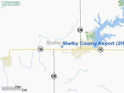
| Shelby County Airport |
| IATA: none â ICAO: none â FAA LID: 2H0 |
| Summary |
| Airport type |
Public |
| Operator |
Shelby County |
| Location |
Shelbyville, Illinois |
| Elevation AMSL |
618 ft / 188.4 m |
| Coordinates |
39°24â²38â³N 88°50â²44â³W / 39.41056°N 88.84556°W / 39.41056; -88.84556Coordinates: 39°24â²38â³N 88°50â²44â³W / 39.41056°N 88.84556°W / 39.41056; -88.84556 |
| Runways |
| Direction |
Length |
Surface |
| ft |
m |
| 18/36 |
4,099 |
1,249 |
Asphalt |
| 14/32 |
3,264 |
995 |
Grass |
| 4/22 |
2,585 |
788 |
Turf |
Shelby County Airport (FAA LID: 2H0) is a public airport located three miles (4.8 km) west of the central business district (CBD) of Shelbyville, a city in Shelby County, Illinois, USA.
Facilities
Shelby County Airport covers 215 acres (87 ha) and has three runways:
- Runway 18/36: 4,099 x 75 ft. (1,249 x 23 m), Surface: Asphalt
- Runway 14/32: 3,264 x 200 ft. (995 x 61 m), Surface: Turf
- Runway 4/22: 2,585 x 200 ft. (788 x 61 m), Surface: Turf
The above content comes from Wikipedia and is published under free licenses – click here to read more.
Location
& QuickFacts
|
FAA
Information Effective: |
2007-12-20 |
|
Airport
Identifier: |
2H0 |
|
Airport
Status: |
Operational |
|
Longitude/Latitude: |
088-50-43.5570W/39-24-37.5430N
-88.845432/39.410429 (Estimated) |
|
Elevation: |
618 ft / 188.37 m (Surveyed) |
|
Land: |
215 acres |
|
From nearest
city: |
3 nautical miles W of Shelbyville, IL |
|
Location: |
Shelby County, IL |
|
Magnetic
Variation: |
01E (1985) |
Owner
& Manager
|
Ownership: |
Publicly
owned |
|
Owner: |
Shelby Co Arpt & Lndg Cmsn. |
|
Address: |
R R 2
Shelbyville, IL 62526 |
|
Phone
number: |
217-783-2780 |
|
Manager: |
Mike Potter |
|
Address: |
Rr 3 Box 38
Shelbyville, IL 62565 |
|
Phone
number: |
217-774-4111 |
Airport
Operations and Facilities
|
Airport
Use: |
Open
to public |
|
Wind indicator: |
Yes |
|
Segmented
Circle: |
No |
|
Control
Tower: |
No |
|
Lighting
Schedule: |
DUSK-DAWN |
|
Beacon
Color: |
Clear-Green (lighted land airport) |
|
Landing
fee charge: |
No |
|
Sectional
chart: |
St Louis |
|
Region: |
AGL - Great Lakes |
|
Traffic
Pattern Alt: |
800 ft |
|
Boundary
ARTCC: |
ZKC - Kansas City |
|
Tie-in
FSS: |
STL - Saint Louis |
|
FSS on
Airport: |
No |
|
FSS Toll
Free: |
1-800-WX-BRIEF |
|
NOTAMs
Facility: |
STL (NOTAM-d service avaliable) |
|
Federal
Agreements: |
NGY |
Airport
Communications
|
CTAF: |
122.800 |
|
Unicom: |
122.800
|
Airport
Services
|
Fuel
available: |
100LL |
|
Airframe
Repair: |
MAJOR |
|
Power
Plant Repair: |
MAJOR |
|
Bottled
Oxygen: |
NONE |
|
Bulk Oxygen: |
NONE |
|
Runway Information
Runway 04/22
|
Dimension: |
2585 x 200 ft
/ 787.9 x 61.0 m |
|
Surface: |
TURF, Good Condition |
|
|
Runway 04 |
Runway 22 |
|
Longitude: |
088-50-52.2570W |
088-50-31.2570W |
|
Latitude: |
39-24-21.1430N |
39-24-41.1420N |
|
Elevation: |
617.00 ft |
613.00 ft |
|
Traffic
Pattern: |
Left |
Left |
|
Markings: |
None,
RYS 4 & 32 DSPLCD THLDS MARKED WITH WHITE GRAVEL 2 FT
WIDE. |
None, |
|
Displaced
threshold: |
484.00 ft |
0.00 ft |
|
Runway End
Identifier: |
No |
No |
|
Centerline
Lights: |
No |
No |
|
Touchdown
Lights: |
No |
No |
|
Obstruction: |
14 ft road, 29.0 ft from runway, 173 ft right
of centerline, 2:1 slope to clear
APCH RATIO 22:1 TO DSPLCD THLD; 53 FT TREE 1211 FT FM DSPLCD
THLD 220 FT R OF CNTRLN. |
16 ft tree, 513.0 ft from runway, 105 ft right
of centerline, 32:1 slope to clear |
|
Runway 14/32
|
Dimension: |
3264 x 200 ft
/ 994.9 x 61.0 m |
|
Surface: |
TURF, Good Condition |
|
|
Runway 14 |
Runway 32 |
|
Traffic
Pattern: |
Left |
Left |
|
Markings: |
None, |
None, |
|
Displaced
threshold: |
0.00 ft |
522.00 ft |
|
Runway End
Identifier: |
No |
No |
|
Centerline
Lights: |
No |
No |
|
Touchdown
Lights: |
No |
No |
|
Obstruction: |
82 ft tree, 3363.0 ft from runway, 165 ft left
of centerline, 41:1 slope to clear |
15 ft road, 6.0 ft from runway, 125 ft left
of centerline
APCH RATIO 20:1 TO DSPLCD THLD; 33 FT ANT 665 FT FM DSPLCD
THLD 179 FT L OF CNTRLN. |
|
Runway 18/36
|
Dimension: |
4099 x 75 ft
/ 1249.4 x 22.9 m |
|
Surface: |
ASPH, Good Condition |
|
Surface Treatment: |
Porous Friction Course |
|
Weight Limit: |
Single wheel: 4000 lbs. |
|
Edge Lights: |
Medium |
|
|
Runway 18 |
Runway 36 |
|
Longitude: |
088-50-51.1780W |
088-50-50.8730W |
|
Latitude: |
39-25-05.7690N |
39-24-25.2590N |
|
Elevation: |
618.00 ft |
618.00 ft |
|
Alignment: |
127 |
127 |
|
Traffic
Pattern: |
Left |
Left |
|
Markings: |
Non-precision instrument, Good Condition |
Non-precision instrument, Good Condition |
|
Crossing
Height: |
0.00 ft |
25.00 ft |
|
VASI: |
|
pulsating/steady burning on left side
PVASI OTS INDEFLY. |
|
Visual Glide
Angle: |
0.00° |
3.00° |
|
Runway End
Identifier: |
No |
No |
|
Centerline
Lights: |
No |
No |
|
Touchdown
Lights: |
No |
No |
|
Obstruction: |
13 ft road, 688.0 ft from runway, 65 ft right
of centerline, 37:1 slope to clear |
12 ft road, 486.0 ft from runway, 23:1 slope
to clear |
|
Radio Navigation
Aids
|
ID |
Type |
Name |
Ch |
Freq |
Var |
Dist |
|
SYZ |
NDB |
Shelbyville |
|
365.00 |
01E |
0.2 nm |
|
TAZ |
NDB |
Taylorville |
|
395.00 |
00E |
23.4 nm |
|
MT |
NDB |
Zebre |
|
347.00 |
00E |
31.3 nm |
|
CZB |
NDB |
Casey |
|
359.00 |
00E |
39.7 nm |
|
LTD |
NDB |
Litchfield |
|
371.00 |
01E |
41.3 nm |
|
LQ |
NDB |
Licol |
|
375.00 |
01W |
46.2 nm |
|
SLO |
NDB |
Salem |
|
400.00 |
01W |
46.4 nm |
|
SP |
NDB |
Huskk |
|
382.00 |
01W |
47.6 nm |
|
FOA |
NDB |
Elm River |
|
353.00 |
00E |
48.2 nm |
|
MTO |
VOR/DME |
Mattoon |
031X |
109.40 |
03E |
26.3 nm |
|
DEC |
VORTAC |
Decatur |
119X |
117.20 |
03E |
19.7 nm |
|
VLA |
VORTAC |
Vandalia |
090X |
114.30 |
04E |
24.1 nm |
|
BIB |
VORTAC |
Bible Grove |
027X |
109.00 |
03E |
34.0 nm |
|
CMI |
VORTAC |
Champaign |
037X |
110.00 |
03E |
45.8 nm |
|
CAP |
VORTAC |
Capital |
074X |
112.70 |
04E |
46.3 nm |
|
SPI |
VORTAC |
Spinner |
74X |
112.70 |
01W |
46.4 nm |
Remarks
- TWY
GUIDANCE AT NGT UTILIZE BLUE REFLECTORS.
- BOUNDARIES
FOR RWYS 4/22 & 14/32 ARE MARKED WITH WHITE PAINTED LINES SPACED
AT 400FT INTERVALS.
- RWY
4/22 NOT ANALYZED ESTAB PRIOR TO 1959.
Based Aircraft
|
Aircraft
based on field: |
31 |
|
Single Engine
Airplanes: |
28 |
|
Multi Engine Airplanes: |
2 |
|
Ultralights: |
1 |
Operational Statistics
Time
Period: 2006-09-01 - 2007-08-31
|
Aircraft
Operations: |
289/Week |
|
Air Taxi: |
2.0% |
|
General Aviation
Local: |
58.0% |
|
General Aviation
Itinerant: |
38.7% |
|
Military: |
1.3% |
Shelby County Airport
Address:
Shelby County, IL
Tel:
217-783-2780,
217-774-4111
Images
and information placed above are from
http://www.airport-data.com/airport/2H0/
We
thank them for the data!
| General
Info |
| Country |
United
States |
| State |
ILLINOIS
|
| FAA ID |
2H0 |
| Latitude |
39-24-37.543N
|
| Longitude |
088-50-43.557W
|
| Elevation |
618 feet
|
| Near City |
SHELBYVILLE
|
We don't guarantee the information is fresh and accurate. The data may
be wrong or outdated.
For more up-to-date information please refer to other sources.
|
|


