 |
|
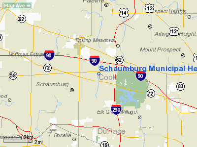
Schaumburg Municipal Helistop Heliport |
|
|
Location
& QuickFacts
|
FAA
Information Effective: |
2007-12-20 |
|
Airport
Identifier: |
4H1 |
|
Airport
Status: |
Operational |
|
Longitude/Latitude: |
088-03-09.2590W/42-02-53.0980N
-88.052572/42.048083 (Estimated) |
|
Elevation: |
730 ft / 222.50 m (Surveyed) |
|
Land: |
2 acres |
|
From nearest
city: |
24 nautical miles NW of Chicago/schaumburg,
IL |
|
Location: |
Cook County, IL |
|
Magnetic
Variation: |
01W (1985) |
Owner
& Manager
|
Ownership: |
Publicly
owned |
|
Owner: |
Village Of Schaumburg |
|
Address: |
101 Schaumburg Ct
Schaumburg, IL 60193 |
|
Phone
number: |
847-895-0007 |
|
Manager: |
June E. Johnson Dir. Of Transp |
|
Address: |
101 Schaumburg Court
Schaumburg, IL 60193 |
|
Phone
number: |
847-923-3859 |
Airport
Operations and Facilities
|
Airport
Use: |
Open
to public |
|
Wind indicator: |
Yes |
|
Segmented
Circle: |
No |
|
Control
Tower: |
No |
|
Lighting
Schedule: |
SS-2200 |
|
Sectional
chart: |
Chicago |
|
Region: |
AGL - Great Lakes |
|
Boundary
ARTCC: |
ZAU - Chicago |
|
Tie-in
FSS: |
IKK - Kankakee |
|
FSS on
Airport: |
No |
|
FSS Toll
Free: |
1-800-WX-BRIEF |
|
NOTAMs
Facility: |
IKK (NOTAM-d service avaliable) |
|
Federal
Agreements: |
N |
Airport
Communications
|
Runway Information
Helipad H1
|
Dimension: |
25 x 25 ft / 7.6 x 7.6 m
CONC PAD HAS 25 FT ASPH AREA ADJACENT - ALL SIDES. 12 FT X 25 FT
PARKING PAD LOCATED 56 FT NW OF LANDING PAD. |
|
Surface: |
CONC, Good Condition |
|
Weight Limit: |
Single wheel: 12500 lbs. |
|
|
Runway H1 |
Runway |
|
Traffic
Pattern: |
Left |
Left |
|
Approach
lights: |
LDIN |
|
|
Radio Navigation
Aids
|
ID |
Type |
Name |
Ch |
Freq |
Var |
Dist |
|
ME |
NDB |
Deana |
|
350.00 |
00E |
5.0 nm |
|
HK |
NDB |
Ermin |
|
332.00 |
01W |
22.0 nm |
|
MX |
NDB |
Kedzi |
|
248.00 |
01W |
24.6 nm |
|
DKB |
NDB |
Dekalb |
|
209.00 |
02W |
30.0 nm |
|
RA |
NDB |
Paser |
|
206.00 |
00E |
38.7 nm |
|
LVV |
NDB |
Lake Lawn |
|
404.00 |
00W |
45.9 nm |
|
ORD |
VOR/DME |
Chicago O'hare |
086X |
113.90 |
02E |
7.5 nm |
|
OBK |
VOR/DME |
Northbrook |
077X |
113.00 |
02W |
11.3 nm |
|
DPA |
VOR/DME |
Dupage |
021X |
108.40 |
02E |
16.3 nm |
|
ENW |
VOR/DME |
Kenosha |
029X |
109.20 |
02W |
33.6 nm |
|
BUU |
VOR/DME |
Burbun |
092X |
114.50 |
01W |
40.1 nm |
|
HRK |
VOR/DME |
Horlick |
124X |
117.70 |
02W |
44.2 nm |
|
JOT |
VORTAC |
Joliet |
070X |
112.30 |
02E |
32.4 nm |
|
CGT |
VORTAC |
Chicago Heights |
089X |
114.20 |
02E |
38.9 nm |
|
EON |
VORTAC |
Peotone |
079X |
113.20 |
02E |
48.2 nm |
|
ORD |
VOT |
Chicago O'hare Intl |
|
112.00 |
|
7.6 nm |
|
MDW |
VOT |
Chicago Midway |
|
111.00 |
|
20.7 nm |
Remarks
- INGRESS/EGRESS
ROUTES ARE 100 DEGS & 240-260 DEGS.
- HELIPORT
CLSD 2200-SR.
- (E111-1)
NO NGT OPS UNLESS WIND INDICATOR LGTD & BCN INSTALLED; UNAUTHORIZED
PERSONS SEGREGATED FM ACCESS DURG FLT OPS BY NON-OBSTG SAFETY BARRIER.
- PRVDD
ALL APCH/DEPOPNS FM 080-100 DEGS & FM 240-260 DEGS; TKOF/LDG AREA
APROPLY MKD; NON-OBSTNG WIND WIND INDICATOR MAINTD; AVOID OVERFLIGHT
OF RESIDENTIAL AREA 2000 FT W.
Operational Statistics
Time
Period: 2004-01-02 - 2004-12-31
|
Aircraft
Operations: |
16/Week |
|
General Aviation
Itinerant: |
100.0% |
Schaumburg Municipal Helistop Heliport
Address:
Cook County, IL
Tel:
847-895-0007,
847-923-3859
Images
and information placed above are from
http://www.airport-data.com/airport/4H1/
We
thank them for the data!
| General
Info |
| Country |
United
States |
| State |
ILLINOIS
|
| FAA ID |
4H1 |
| Latitude |
42-02-53.098N
|
| Longitude |
088-03-09.259W
|
| Elevation |
730 feet
|
| Near City |
CHICAGO/SCHAUMBURG
|
We don't guarantee the information is fresh and accurate. The data may
be wrong or outdated.
For more up-to-date information please refer to other sources.
|
|


