 |
|
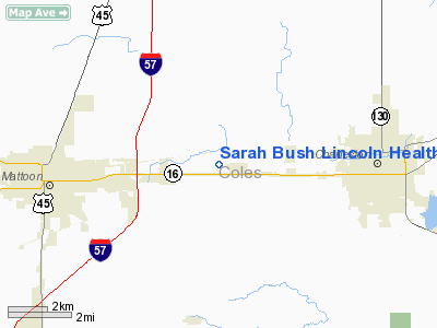
Sarah Bush Lincoln Health Center Heliport |
Location
& QuickFacts
|
FAA
Information Effective: |
2007-12-20 |
|
Airport
Identifier: |
21IL |
|
Airport
Status: |
Operational |
|
Longitude/Latitude: |
088-16-24.0000W/39-29-20.0000N
-88.273333/39.488889 (Estimated) |
|
Elevation: |
702 ft / 213.97 m (Estimated) |
|
Land: |
0 acres |
|
From nearest
city: |
5 nautical miles E of Mattoon, IL |
|
Location: |
Coles County, IL |
|
Magnetic
Variation: |
01W (1995) |
Owner
& Manager
|
Ownership: |
Privately
owned |
|
Owner: |
Sarah Bush Lincoln Health Center |
|
Address: |
1000 Health Center Dr
Mattoon, IL 61938 |
|
Phone
number: |
217-258-2577 |
|
Manager: |
Larry Gouveia |
|
Address: |
1000 Health Center Drive
Mattoon, IL 61938 |
|
Phone
number: |
217-258-2577 |
Airport
Operations and Facilities
|
Airport
Use: |
Private |
|
Wind indicator: |
Yes |
|
Segmented
Circle: |
No |
|
Control
Tower: |
No |
|
Lighting
Schedule: |
24 HRS |
|
Beacon
Color: |
Clear-Green-Yellow (heliport) |
|
Sectional
chart: |
St Louis |
|
Region: |
AGL - Great Lakes |
|
Boundary
ARTCC: |
ZKC - Kansas City |
|
Tie-in
FSS: |
STL - Saint Louis |
|
FSS Toll
Free: |
1-800-WX-BRIEF |
|
Runway Information
Helipad H1
|
Dimension: |
50 x 50 ft /
15.2 x 15.2 m |
|
Surface: |
CONC, |
|
|
Runway H1 |
Runway |
|
Traffic
Pattern: |
Left |
Left |
|
Radio Navigation
Aids
|
ID |
Type |
Name |
Ch |
Freq |
Var |
Dist |
|
MT |
NDB |
Zebre |
|
347.00 |
00E |
5.4 nm |
|
CZB |
NDB |
Casey |
|
359.00 |
00E |
16.8 nm |
|
SYZ |
NDB |
Shelbyville |
|
365.00 |
01E |
26.9 nm |
|
PRG |
NDB |
Paris |
|
341.00 |
01E |
30.5 nm |
|
HMJ |
NDB |
Homer |
|
281.00 |
01E |
35.5 nm |
|
PLX |
NDB |
Palestine |
|
391.00 |
00W |
41.0 nm |
|
HU |
NDB |
Yinno |
|
245.00 |
02W |
41.1 nm |
|
SIV |
NDB |
Sullivan |
|
326.00 |
02W |
44.6 nm |
|
OLY |
NDB |
Olney |
|
272.00 |
00W |
46.6 nm |
|
TAZ |
NDB |
Taylorville |
|
395.00 |
00E |
48.8 nm |
|
FOA |
NDB |
Elm River |
|
353.00 |
00E |
50.0 nm |
|
MTO |
VOR/DME |
Mattoon |
031X |
109.40 |
03E |
0.9 nm |
|
RSV |
VOR/DME |
Robinson |
021X |
108.40 |
02E |
40.6 nm |
|
DEC |
VORTAC |
Decatur |
119X |
117.20 |
03E |
30.9 nm |
|
CMI |
VORTAC |
Champaign |
037X |
110.00 |
03E |
32.8 nm |
|
BIB |
VORTAC |
Bible Grove |
027X |
109.00 |
03E |
35.5 nm |
|
TTH |
VORTAC |
Terre Haute |
100X |
115.30 |
02E |
47.5 nm |
|
VLA |
VORTAC |
Vandalia |
090X |
114.30 |
04E |
47.7 nm |
Remarks
- PRVDD
ALL APCH/DEP 025-035 & 175-185, AREA IS MKD, WIND INDICATOR IS MAINTAINED
& COMPLY WITH FAR PART 91.126(B){2}.
Sarah Bush Lincoln Health Center Heliport
Address:
Coles County, IL
Tel:
217-258-2577
Images
and information placed above are from
http://www.airport-data.com/airport/21IL/
We
thank them for the data!
| General
Info |
| Country |
United
States |
| State |
ILLINOIS
|
| FAA ID |
21IL |
| Latitude |
39-29-20.000N
|
| Longitude |
088-16-24.000W
|
| Elevation |
702 feet
|
| Near City |
MATTOON
|
We don't guarantee the information is fresh and accurate. The data may
be wrong or outdated.
For more up-to-date information please refer to other sources.
|
|


