 |
|
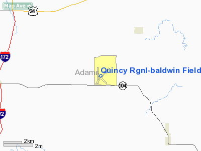
Quincy Regional-Baldwin Field Airport |
Quincy Regional Airport
Baldwin Field |
 |
 |
| IATA: UIN â ICAO: KUIN â FAA LID: UIN |
| Summary |
| Airport type |
Public |
| Owner |
City of Quincy |
| Serves |
Quincy, Illinois |
| Elevation AMSL |
768 ft / 234 m |
| Coordinates |
39°56â²35â³N 091°11â²40â³W / 39.94306°N 91.19444°W / 39.94306; -91.19444 |
| Runways |
| Direction |
Length |
Surface |
| ft |
m |
| 4/22 |
7,098 |
2,163 |
Asphalt/Concrete |
| 18/36 |
5,400 |
1,646 |
Asphalt/Concrete |
| 13/31 |
5,396 |
1,645 |
Asphalt |
| Statistics (2008) |
| Aircraft operations |
22,595 |
| Based aircraft |
47 |
| Source: Federal Aviation Administration |
Quincy Regional Airport (IATA: UIN, ICAO: KUIN, FAA LID: UIN), also known as Baldwin Field, is a city-owned, public-use airport located 10 nautical miles (19 km) east of the central business district of Quincy, a city in Adams County, Illinois, United States. It is mostly used for general aviation, but is also served by American Airlines partner Cape Air with subsidized Essential Air Service program flights to Lambert-St. Louis International Airport.
On November 6, 2006, Mesa Airlines announced that new non-stop service to Chicago Midway International Airport and Kirksville Regional Airport would begin in February, 2007 operated by their wholly-owned subsidiary, Air Midwest. However, just nine months after starting the service, Mesa announced they would end all service from Quincy on November 9, 2007. The airport was also formerly served by Trans World Express, United Express, and Great Lakes Airlines. Facilities and aircraft
Quincy Regional-Baldwin Field is an uncontrolled airport that covers an area of 1,101 acres (446 ha) at an elevation of 768 feet (234 m) above mean sea level. It has three runways with asphalt and concrete surfaces: 4/22 is 7,098 by 150 feet (2,163 x 46 m); 18/36 is 5,400 by 150 feet (1,646 x 46 m); 13/31 is 5,396 by 150 feet (1,645 x 46 m).
For the 12-month period ending October 31, 2008, the airport had 22,595 aircraft operations, an average of 61 per day: 84% general aviation, 12% scheduled commercial, 3% air taxi and 2% military. At that time there were 47 aircraft based at this airport: 62% single-engine, 15% multi-engine, 19% jet and 4% helicopter.
Airlines and destinations
| Airlines |
Destinations |
| Cape Air |
St. Louis |
Incidents
On November 19, 1996, United Express Flight 5925 from Chicago and Burlington crashed on landing at Quincy. A Beechcraft King Air was attempting to takeoff on an intersecting runway while the Beechcraft 1900 landed. The aircraft collided at the intersection of the two runways. All 12 on the 1900 and 2 on the King Air were killed in the accident.
The above content comes from Wikipedia and is published under free licenses – click here to read more.
|
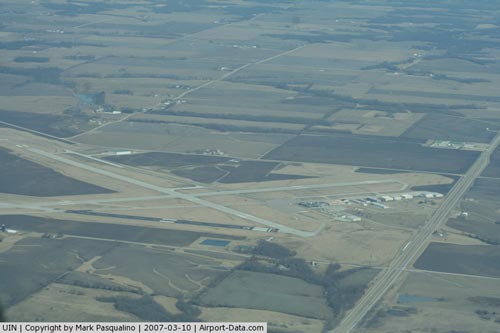 |
(Click on the photo to enlarge) |
Location
& QuickFacts
|
FAA
Information Effective: |
2007-12-20 |
|
Airport
Identifier: |
UIN |
|
Airport
Status: |
Operational |
|
Longitude/Latitude: |
091-11-40.0693W/39-56-34.8640N
-91.194464/39.943018 (Estimated) |
|
Elevation: |
768 ft / 234.09 m (Surveyed) |
|
Land: |
1101 acres |
|
From nearest
city: |
10 nautical miles E of Quincy, IL |
|
Location: |
Adams County, IL |
|
Magnetic
Variation: |
02E (1985) |
Owner
& Manager
|
Ownership: |
Publicly
owned |
|
Owner: |
City Of Quincy |
|
Address: |
1645 Hwy 104
Quincy, IL 62305 |
|
Phone
number: |
217-885-3262 |
|
Manager: |
Marty Stegeman |
|
Address: |
1645 Hwy 104
Quincy, IL 62305 |
|
Phone
number: |
217-885-3285 |
Airport
Operations and Facilities
|
Airport
Use: |
Open
to public |
|
Wind indicator: |
Yes |
|
Segmented
Circle: |
Yes |
|
Control
Tower: |
No |
|
Lighting
Schedule: |
DUSK-DAWN
HIRL RY 04/22 PRESET LOW INTST; TO INCR INTST & ACTVT
MIRL RY 13/31; MIRL RY 18/36 & MALSR RY 04 - CTAF. |
|
Beacon
Color: |
Clear-Green (lighted land airport) |
|
Landing
fee charge: |
No |
|
Sectional
chart: |
Kansas City |
|
Region: |
AGL - Great Lakes |
|
Traffic
Pattern Alt: |
1000 ft |
|
Boundary
ARTCC: |
ZKC - Kansas City |
|
Tie-in
FSS: |
STL - Saint Louis |
|
FSS on
Airport: |
No |
|
FSS Toll
Free: |
1-800-WX-BRIEF |
|
NOTAMs
Facility: |
UIN (NOTAM-d service avaliable) |
|
Certification
type/date: |
II A S 05/197
48 HR PPR FOR UNSKED ACR OPNS INVOLVING AIRCRAFT WITH MORE
THAN 30 PASSENGER SEATS. CALL AMGR 217-885-3285 OR 217-885-3262
DURING BUSINESS HRS. |
|
Federal
Agreements: |
NGY3 |
Airport
Communications
|
CTAF: |
123.000 |
|
Unicom: |
123.000
|
Airport
Services
|
Fuel
available: |
100LLA |
|
Airframe
Repair: |
MAJOR |
|
Power
Plant Repair: |
MAJOR |
|
Runway Information
Runway 04/22
|
Dimension: |
7098 x 150 ft
/ 2163.5 x 45.7 m |
|
Surface: |
ASPH-CONC, Good Condition
NE 1300 FT OF RY 04/22 CONC.
N 479 FT OF RY 18/36 CONC. |
|
Surface Treatment: |
Saw-cut or plastic Grooved |
|
Weight Limit: |
Single wheel: 60000 lbs.
Dual wheel: 75000 lbs.
Dual tandem wheel: 150000 lbs. |
|
Edge Lights: |
High |
|
|
Runway 04 |
Runway 22 |
|
Longitude: |
091-11-58.4263W |
091-10-59.4679W |
|
Latitude: |
39-56-10.1226N |
39-57-03.6087N |
|
Elevation: |
756.00 ft |
764.00 ft |
|
Alignment: |
40 |
127 |
|
ILS Type: |
ILS |
|
|
Traffic
Pattern: |
Left |
Left |
|
Markings: |
Precision instrument, Fair Condition |
Precision instrument, Fair Condition |
|
Crossing
Height: |
0.00 ft |
43.00 ft |
|
VASI: |
|
4-box on left side |
|
Visual Glide
Angle: |
0.00° |
3.00° |
|
Approach
lights: |
MALSR |
|
|
Runway End
Identifier: |
|
Yes |
|
Centerline
Lights: |
No |
No |
|
Touchdown
Lights: |
No |
No |
|
Obstruction: |
16 ft road, 848.0 ft from runway, 586 ft right
of centerline, 40:1 slope to clear |
, 50:1 slope to clear |
|
Runway 13/31
|
Dimension: |
5396 x 150 ft
/ 1644.7 x 45.7 m |
|
Surface: |
ASPH, Good Condition
NE 1300 FT OF RY 04/22 CONC.
N 479 FT OF RY 18/36 CONC. |
|
Surface Treatment: |
Saw-cut or plastic Grooved |
|
Weight Limit: |
Single wheel: 75000 lbs.
Dual wheel: 95000 lbs.
Dual tandem wheel: 150000 lbs. |
|
Edge Lights: |
Medium |
|
|
Runway 13 |
Runway 31 |
|
Longitude: |
091-12-01.9032W |
091-11-13.1681W |
|
Latitude: |
39-56-44.9910N |
39-56-07.0956N |
|
Elevation: |
765.00 ft |
0.00 ft |
|
Alignment: |
127 |
127 |
|
Traffic
Pattern: |
Left |
Left |
|
Markings: |
Non-precision instrument, Good Condition |
Non-precision instrument, Good Condition |
|
Crossing
Height: |
31.00 ft |
0.00 ft |
|
VASI: |
4-box on left side |
|
|
Visual Glide
Angle: |
3.00° |
0.00° |
|
Runway End
Identifier: |
No |
No |
|
Centerline
Lights: |
No |
No |
|
Touchdown
Lights: |
No |
No |
|
Obstruction: |
11 ft road, 525.0 ft from runway, 300 ft right
of centerline, 29:1 slope to clear |
15 ft pole, 800.0 ft from runway, 200 ft left
of centerline, 40:1 slope to clear |
|
Decleard
distances: |
Take off run available 5396.00 ft
Take off distance available 5396.00 ft
Actual stop distance available 5123.00 ft
Landing distance available 5123.00 ft |
Take off run available 5396.00 ft
Take off distance available 5396.00 ft
Actual stop distance available 5146.00 ft
Landing distance available 5146.00 ft |
|
Runway 18/36
|
Dimension: |
5400 x 150 ft
/ 1645.9 x 45.7 m |
|
Surface: |
ASPH-CONC, Good Condition
NE 1300 FT OF RY 04/22 CONC.
N 479 FT OF RY 18/36 CONC. |
|
Weight Limit: |
Single wheel: 45000 lbs.
Dual wheel: 55000 lbs.
Dual tandem wheel: 100000 lbs. |
|
Edge Lights: |
Medium |
|
|
Runway 18 |
Runway 36 |
|
Longitude: |
091-11-57.6310W |
091-11-56.8103W |
|
Latitude: |
39-57-07.7289N |
39-56-14.3651N |
|
Elevation: |
757.00 ft |
757.00 ft |
|
Alignment: |
127 |
127 |
|
Traffic
Pattern: |
Left |
Left |
|
Markings: |
Non-precision instrument, Good Condition |
Non-precision instrument, Good Condition |
|
Runway End
Identifier: |
Yes |
No |
|
Centerline
Lights: |
No |
No |
|
Touchdown
Lights: |
No |
No |
|
Obstruction: |
|
16 ft road, 976.0 ft from runway, 245 ft left
of centerline, 48:1 slope to clear |
|
Radio Navigation
Aids
|
ID |
Type |
Name |
Ch |
Freq |
Var |
Dist |
|
UI |
NDB |
Quincy |
|
293.00 |
02E |
4.3 nm |
|
HAE |
NDB |
Hannibal |
|
411.00 |
03E |
17.5 nm |
|
PPQ |
NDB |
Pittsfield |
|
344.00 |
02E |
26.3 nm |
|
EOK |
NDB |
Keokuk |
|
366.00 |
02E |
33.2 nm |
|
JZY |
NDB |
Macomb |
|
251.00 |
01E |
45.2 nm |
|
IJX |
VOR/DME |
Jacksonville |
023X |
108.60 |
02E |
45.2 nm |
|
UIN |
VORTAC |
Quincy |
083X |
113.60 |
05E |
6.9 nm |
|
BRL |
VORTAC |
Burlington |
051X |
111.40 |
05E |
48.5 nm |
Remarks
- MIGRATORY
WATERFOWL ON & INVOF ARPT.
Based Aircraft
|
Aircraft
based on field: |
53 |
|
Single Engine
Airplanes: |
32 |
|
Multi Engine Airplanes: |
6 |
|
Jet Engine Airplanes: |
13 |
|
Helicopters: |
1 |
|
Ultralights: |
1 |
Operational Statistics
Time
Period: 2006-03-16 - 2007-03-16
|
Aircraft
Operations: |
69/Day |
|
Commerical: |
11.6% |
|
Air Taxi: |
3.0% |
|
General Aviation
Local: |
67.5% |
|
General Aviation
Itinerant: |
15.9% |
|
Military: |
2.0% |
Quincy Regional-baldwin Field Airport
Address:
Adams County, IL
Tel:
217-885-3262,
217-885-3285
Images
and information placed above are from
http://www.airport-data.com/airport/UIN/
We
thank them for the data!
| General
Info |
| Country |
United
States |
| State |
ILLINOIS
|
| FAA ID |
UIN |
| Latitude |
39-56-33.840N
|
| Longitude |
091-11-40.440W
|
| Elevation |
769 feet
|
| Near City |
QUINCY
|
We don't guarantee the information is fresh and accurate. The data may
be wrong or outdated.
For more up-to-date information please refer to other sources.
|
|


