|
 |
|
||||
|
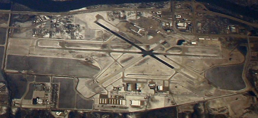
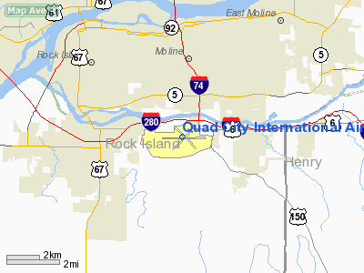
Quad City International Airport (IATA: MLI, ICAO: KMLI, FAA LID: MLI) is a public airport located three miles (5 km) south of the central business district of Moline, a city in Rock Island County, Illinois, United States. It is owned by the Metropolitan Airport Authority. It serves the Quad Cities area of Illinois and Iowa. The Quad City International Airport is the third-busiest commercial airport in Illinois â Chicago's O'Hare and Midway International Airports respectively lead the state. The international designation is for being an official port of entry and having a customs service. A Foreign Trade Zone and U.S. Customs Office are located at the airport, enabling international inbound and outbound shipments. HistoryFraning Field, the site of the present Quad City International Airport, was picked as an ideal flying field, which consisted of 120 acres (49 ha) of level, grassy land free of obstacles. The airport made headlines right at the start, chosen as a control point for the first coast-to-coast flight in the fall of 1919. On August 18th, 1927, an estimated 10,000 people came to welcome Charles Lindbergh in Moline and his famous plane, the Spirit of St. Louis on the Gugenheim tour, a cross-country commercial aviation promotion tour. In 1929, Phoebe Omlie set an altitude record above the airport in a Velie Monocoupe, the only plane ever manufactured in Moline, which still hangs in the passenger terminal. In 1947, the Metropolitan Airport Authority of Rock Island County was formed after seven townships voted to establish it. In 1957, the first count of enplaning and deplaning passengers was made with a total of 59,701 recorded. The airport underwent major remodeling in 1961 and 1968, adding everything from baggage claim to a restaurant and passenger boarding areas. The current airport terminal was completed in 1985, after studies showed that an addition to the 1954 structure would prove more costly than building an entirely new terminal. The shift to the new $11 million terminal created many new opportunities for expansion of airline facilities. Between 1979 and 1986, the number of airlines increased from two to seven. Major carriers flying mainline jets to the Quad Cities have included America West Airlines, American Airlines, Northwest Airlines, Ozark Air Lines, Pan American World Airways, Trans World Airlines, and United Airlines. In the early and mid-1990s, turboprop equipment was much more prevalent. Northwest Airlink as well as other airlines operated daily flights to/from QCIA on Saab 340B turboprop aircraft. Carriers like Northwest Airlink have almost completely replaced their turboprop equipment with newer regional jets. In fact, every commercial flight out of Quad City International is now served by jet aircraft. In 2001, the terminal underwent a major renovation and expansion that included two new concourses, a larger baggage claim area, new restaurants, and gift shops. The completion of the project doubled the size of the passenger terminal. In 2004, Northwest Airlines announced major expansion plans for Quad City International with their feeder carrier, Northwest Airlink. United Airlines also recently expanded its Denver, market at MLI. The larger-jet service to this airport is provided by AirTran Airways, which uses 117-seat Boeing 717s to fly between Quad City International and Atlanta, Georgia, and Orlando, Florida. On August 10th, 2010, AirTran Airways announced that it will cancel nonstop service to Atlanta, Georgia from Moline on November 30th. Also announced was a nonstop flight from Moline to Fort Myers, Florida beginning in the first quarter of 2011. On August 19th, 2010, Allegiant Air announced that they will begin nonstop service from Moline to McCarran International Airport in Las Vegas, Nevada. Flights will be every Thursday and Sunday beginning October 30th. The Quad City International Airport has experienced steady growth in terms of passengers enplaned and has increasingly expanded the amount of direct flight options. In 2006, for the first time in history, 911,522 passengers arrived at and departed from Quad City International Airport. Traffic was up 6% over 2005 and broke the previous annual passenger record held in 2004 by over 34,000 passengers. In 2006, 456,802 passengers were enplaned and 454,720 were deplaned. In 2008, 957,087 total passengers enplaned and deplaned from the airport, down 1% from 2007 which broke a record at 966,142 total passengers. Facilities and aircraft
Quad City International Airport covers 2,600 acres (1,052 ha) and has three runways:
The airfield at the Quad City International Airport can accommodate any type of aircraft in virtually any type of weather conditions with the long runways, ILS, and high-intensity lighting. Airport officials claim that the airport is possibly capable of handling the new Airbus A380. The airfield has gone through many changes over the past few years as well, including extending Taxiway Hotel. Also, Runway 5/23 has been expanded to a usable 5015 feet. Runway 9/27, the airport's longest runway, is currently going through a complete reconstruction program which will include a temporary 6,500 foot parallel runway (10/28) constructed during the project. The new runway 9/27 will include new pavement, new shoulder construction, taxiway additions, and a new glide-slope capture effect kit for runway 9. The cost of the project will total $33 million and is expected to be complete by late 2012. For the 12-month period ending December 31, 2006, the airport had 50,604 aircraft operations, an average of 138 per day: 50% general aviation, 38% air taxi, 10% scheduled commercial and 2% military. At that time there were 88 aircraft based at this airport: 68% single-engine, 23% multi-engine, 8% jet and 1% helicopter. The airport is designated international for having a port of entry customs service. A Foreign Trade Zone and U.S. Customs Office are located at the airport, enabling international inbound and outbound shipments. There are three cargo facilities for every available ramp and the airport has expansion capabilities. A number of air freight companies are located at the airport including BAX Global, DHL, and UPS Supply Chain Solutions. Fixed Base Operators (FBO's) include: Elliott Aviation DPK&A of Philadelphia, Pennsylvania, designed the new passenger air terminal concourses. ServicesAir Host Restaurant is a full-service restaurant in the main terminal. There is also a full-service bar, Paradies Gift Shop, shoe shine service, and a post office in the main terminal. Beyond the security checkpoint in Concourses A & B, there is a snack bar and lounge as well as a recently completed Gevalia Kaffe Coffee Shop. In Concourse B, there is a CNBC News and Gift Shop, along with a chair massage stand. Free wireless internet (Wi-Fi) is available throughout the airport. A new consolidated and enclosed rental car facility was constructed during the summer of 2007. The terminal also features Destination Points, a Frequent Flyer Lounge available for members only. Art galleries have lined the corridors at the Quad City International Airport, featuring modern and contemporary art. There is also a visitor information center in the main terminal for arriving passengers. The airport boasts the regional headquarters for the Department of Homeland Security's Transportation Security Administration, whose offices are located on the second floor of the passenger terminal. In June 2008, Mesaba Airlines opened a maintenance facility for the airline's regional jet aircraft, situated in the airport's cargo building. A new "in-airport" hotel, Hampton Inn & Suites, was also just recently completed on airport property, connecting to the parking lot. Airlines and destinations
All passengers enter the airport at the main terminal and then proceed to either Concourse A (gates A1-A6) or Concourse B (gates B5, B7, B8, B8A, B9 - B11, B15, B17).
The above content comes from Wikipedia and is published under free licenses – click here to read more.
Runway InformationRunway 05/23
Runway 09/27
Runway 13/31
Radio Navigation Aids
Remarks
Based Aircraft
Major Carriers Serving This Airport
Most Popular Destinations
Most Popular Aircraft
Operational StatisticsTime Period: 2006-01-01 - 2006-12-31
Quad City International Airport Address: Rock Island County, IL Tel: 309-764-9621 Images
and information placed above are from We thank them for the data!
We don't guarantee the information is fresh and accurate. The data may
be wrong or outdated.
|
||||||||||||||||||||||||||||||||||||||||||||||||||||||||||||||||||||||||||||||||||||||||||||||||||||||||||||||||||||||||||||||||||||||||||||||||||||||||||||||||||||||||||||||||||||||||||||||||||||||||||||||||||||||||||||||||||||||||||||||||||||||||||||||||||||||||||||||||||||||||||||||||||||||||||||||||||||||||||||||||||||||||||||||||||||||||||||||||||||||||||||||||||||||||||||||||||||||||||||||||||||||||||||||||||||||||||||||||||||||||||||||||||||||||||||||||||||||||||||||||||||||||||||||||||||||||||||||||||||||||||||||||||||||||||||||||||||||||||||||||||||||||||

 |
|
Copyright 2004-2024 © by Airports-Worldwide.com, Vyshenskoho st. 36, Lviv 79010, Ukraine Legal Disclaimer |