 |
|
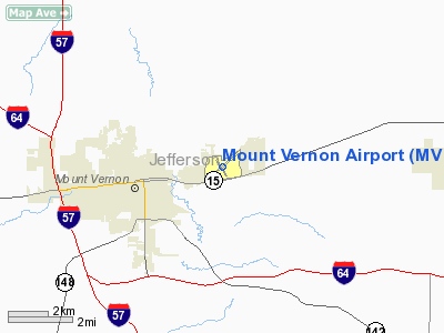
| Mount Vernon Airport |
| IATA: MVN â ICAO: KMVN â FAA LID: MVN |
| Summary |
| Airport type |
Public |
| Operator |
Mount Vernon Airport Authority |
| Location |
Mount Vernon, Illinois |
| Elevation AMSL |
480 ft / 146.3 m |
| Coordinates |
38°19â²24â³N 88°51â²31â³W / 38.32333°N 88.85861°W / 38.32333; -88.85861Coordinates: 38°19â²24â³N 88°51â²31â³W / 38.32333°N 88.85861°W / 38.32333; -88.85861 |
| Runways |
| Direction |
Length |
Surface |
| ft |
m |
| 5/23 |
6,498 |
1,981 |
Asphalt |
| 15/33 |
3,149 |
960 |
Asphalt |
Mount Vernon Airport (IATA: MVN, ICAO: KMVN) is a general aviation airport located three miles (5 km) east of the central business district (CBD) of Mount Vernon, a town in Jefferson County, Illinois, USA. It is not currently served by any scheduled airline service, but it was once served by Air Kentucky doing business as US Airways Express.
Facilities
Mount Vernon Airport covers 1,100 acres (445 ha) and has two runways:
- Runway 5/23: 6,498 Ã 150 ft. (1,981 Ã 46 m), Surface: Asphalt
- Runway 15/33: 3,149 Ã 100 ft. (960 Ã 30 m), Surface: Asphalt
The above content comes from Wikipedia and is published under free licenses – click here to read more.
Location
& QuickFacts
|
FAA
Information Effective: |
2007-12-20 |
|
Airport
Identifier: |
MVN |
|
Airport
Status: |
Operational |
|
Longitude/Latitude: |
088-51-30.5250W/38-19-24.0760N
-88.858479/38.323354 (Estimated) |
|
Elevation: |
480 ft / 146.30 m (Surveyed) |
|
Land: |
1100 acres |
|
From nearest
city: |
3 nautical miles E of Mount Vernon, IL |
|
Location: |
Jefferson County, IL |
|
Magnetic
Variation: |
01W (2000) |
Owner
& Manager
|
Ownership: |
Publicly
owned |
|
Owner: |
Mt Vernon Arpt Authority |
|
Address: |
100 Aviation Drive
Mt
Vernon, IL 62864 |
|
Phone
number: |
618-242-7016 |
|
Manager: |
Chris Collins |
|
Address: |
100 Aviation Drive
Mt
Vernon, IL 62864 |
|
Phone
number: |
618-242-7016 |
Airport Operations
and Facilities
|
Airport
Use: |
Open
to public |
|
Wind indicator: |
Yes |
|
Segmented
Circle: |
Yes |
|
Control
Tower: |
No |
|
Lighting
Schedule: |
DUSK-DAWN
ACTVT MIRL RY 15/33 & HIRL RY 05/23; MALSR RY 23 - CTAF. |
|
Beacon
Color: |
Clear-Green (lighted land airport) |
|
Landing
fee charge: |
No |
|
Sectional
chart: |
St Louis |
|
Region: |
AGL - Great Lakes |
|
Boundary
ARTCC: |
ZKC - Kansas City |
|
Tie-in
FSS: |
STL - Saint Louis |
|
FSS on
Airport: |
No |
|
FSS Toll
Free: |
1-800-WX-BRIEF |
|
NOTAMs
Facility: |
MVN (NOTAM-d service avaliable) |
|
Certification
type/date: |
IV A U 05/197
CLSD TO SCHEDULED ACR OPNS WITH GREATER THAN 9 PAX SEATS
& UNSCHEDULED ACR OPS GREATER THAN 30 PAX SEATS. 90-DAY
PPR; CALL 618-242-7016. |
|
Federal
Agreements: |
NGY |
Airport Communications
|
CTAF: |
123.000 |
|
Unicom: |
123.000
|
Airport Services
|
Fuel
available: |
100LLA |
|
Airframe
Repair: |
MAJOR |
|
Power
Plant Repair: |
MAJOR |
|
Bulk Oxygen: |
LOW |
|
Runway Information
Runway 05/23
|
Dimension: |
6498 x 150 ft
/ 1980.6 x 45.7 m |
|
Surface: |
ASPH, |
|
Surface Treatment: |
Porous Friction Course |
|
Weight Limit: |
Single wheel: 50000 lbs.
Dual wheel: 90000 lbs.
Dual tandem wheel: 110000 lbs. |
|
Edge Lights: |
High |
|
|
Runway 05 |
Runway 23 |
|
Longitude: |
088-52-00.3200W |
088-50-57.7900W |
|
Latitude: |
38-19-04.1400N |
38-19-45.3800N |
|
Elevation: |
467.00 ft |
468.00 ft |
|
Alignment: |
50 |
127 |
|
ILS Type: |
|
ILS
|
|
Traffic
Pattern: |
Left |
Left |
|
Markings: |
Precision instrument, Fair Condition |
Precision instrument, Fair Condition |
|
Crossing
Height: |
32.00 ft |
0.00 ft |
|
Displaced
threshold: |
773.00 ft |
0.00 ft |
|
VASI: |
4-box on left side |
|
|
Visual Glide
Angle: |
3.00° |
0.00° |
|
Approach
lights: |
|
MALSR |
|
Runway End
Identifier: |
|
No |
|
Centerline
Lights: |
No |
No |
|
Touchdown
Lights: |
No |
No |
|
Obstruction: |
12 ft road, 200.0 ft from runway, 395 ft right
of centerline
APCH RATIO TO DSPLCD THLD 34:1 OVR TREES 2583 FT FM DSPLCD
THLD 158 FT R OF CNTRLN.
12 FT ROAD 0-200 FT FM THLD 395 FT R TO 495 FT R OF CNTRLN. |
97 ft trees, 2988.0 ft from runway, 54 ft left
of centerline, 28:1 slope to clear |
|
Runway 15/33
|
Dimension: |
3149 x 100 ft
/ 959.8 x 30.5 m |
|
Surface: |
ASPH, Good Condition |
|
Surface Treatment: |
Porous Friction Course |
|
Weight Limit: |
Single wheel: 12000 lbs. |
|
Edge Lights: |
Medium |
|
|
Runway 15 |
Runway 33 |
|
Longitude: |
088-51-43.5600W |
088-51-23.8000W |
|
Latitude: |
38-19-36.1200N |
38-19-09.1600N |
|
Elevation: |
480.00 ft |
458.00 ft |
|
Alignment: |
127 |
127 |
|
Traffic
Pattern: |
Left |
Left |
|
Markings: |
Basic, Good Condition |
Basic, Good Condition |
|
Runway End
Identifier: |
No |
|
|
Centerline
Lights: |
No |
No |
|
Touchdown
Lights: |
No |
No |
|
Obstruction: |
63 ft tree, 873.0 ft from runway, 180 ft left
of centerline, 10:1 slope to clear |
23 ft rr, 613.0 ft from runway, 166 ft left
of centerline, 19:1 slope to clear |
|
Helipad H1
|
Dimension: |
80 x 40 ft /
24.4 x 12.2 m |
|
Surface: |
CONC, |
|
|
Runway H1 |
Runway |
|
Traffic
Pattern: |
Left |
Left |
|
Radio Navigation
Aids
|
ID |
Type |
Name |
Ch |
Freq |
Var |
Dist |
|
SLO |
NDB |
Salem |
|
400.00 |
01W |
19.9 nm |
|
FWC |
NDB |
Wayne County |
|
257.00 |
01E |
21.4 nm |
|
FOA |
NDB |
Elm River |
|
353.00 |
00E |
28.2 nm |
|
PJY |
NDB |
Pinckneyville |
|
215.00 |
00E |
31.7 nm |
|
HSB |
NDB |
Harrisburg-raleigh |
|
230.00 |
00E |
34.1 nm |
|
CUL |
NDB |
Carmi |
|
332.00 |
01W |
37.5 nm |
|
OLY |
NDB |
Olney |
|
272.00 |
00W |
40.0 nm |
|
SAR |
NDB |
Sparta |
|
239.00 |
01E |
41.3 nm |
|
BL |
NDB |
Belleville |
|
362.00 |
02E |
43.1 nm |
|
SKE |
TACAN |
Scott |
059X |
|
02E |
48.6 nm |
|
VNN |
VOR/DME |
Mount Vernon |
085X |
113.80 |
02E |
3.3 nm |
|
MWA |
VOR/DME |
Marion |
041X |
110.40 |
04E |
35.0 nm |
|
SAM |
VOR/DME |
Samsville |
113X |
116.60 |
03E |
37.7 nm |
|
ENL |
VORTAC |
Centralia |
097X |
115.00 |
04E |
15.3 nm |
|
BIB |
VORTAC |
Bible Grove |
027X |
109.00 |
03E |
40.0 nm |
|
VLA |
VORTAC |
Vandalia |
090X |
114.30 |
04E |
48.4 nm |
Remarks
- SW
GEN AVIATION APRON CLSD EXCP BY PPR FM AMGR; CTC 618-242-7016.
- MIGRATORY
WATERFOWL AND DEER ON AND INVOF. ARPT
Based Aircraft
|
Aircraft
based on field: |
46 |
|
Single Engine
Airplanes: |
29 |
|
Multi Engine Airplanes: |
5 |
|
Helicopters: |
2 |
|
Ultralights: |
10 |
Operational Statistics
Time
Period: 2005-01-01 - 2005-12-31
|
Aircraft
Operations: |
91/Day |
|
Air Taxi: |
7.6% |
|
General Aviation
Local: |
45.5% |
|
General Aviation
Itinerant: |
45.5% |
|
Military: |
1.5% |
Mount Vernon Airport
Address:
Jefferson County, IL
Tel:
618-242-7016
Images
and information placed above are from
http://www.airport-data.com/airport/MVN/
We
thank them for the data!
| General
Info |
| Country |
United
States |
| State |
ILLINOIS
|
| FAA ID |
MVN |
| Latitude |
38-19-24.076N
|
| Longitude |
088-51-30.525W
|
| Elevation |
480 feet
|
| Near City |
MOUNT
VERNON |
We don't guarantee the information is fresh and accurate. The data may
be wrong or outdated.
For more up-to-date information please refer to other sources.
|
|


