 |
|
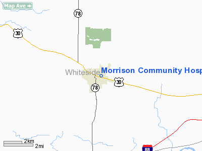
Morrison Community Hospital Heliport |
Location
& QuickFacts
|
FAA
Information Effective: |
2007-12-20 |
|
Airport
Identifier: |
5LL9 |
|
Airport
Status: |
Operational |
|
Longitude/Latitude: |
089-57-27.0000W/41-48-34.0000N
-89.957500/41.809444 (Estimated) |
|
Elevation: |
634 ft / 193.24 m (Estimated) |
|
Land: |
0 acres |
|
From nearest
city: |
0 nautical miles E of Morrison, IL |
|
Location: |
Whiteside County, IL |
|
Magnetic
Variation: |
() |
Owner
& Manager
|
Ownership: |
Publicly
owned |
|
Owner: |
Morrison Community Hospital Distr |
|
Address: |
303 N Jackson St
Morrison,
IL 61270 |
|
Phone
number: |
815-772-4003 |
|
Manager: |
Terry Amstutz, Ceo |
|
Address: |
303 N Jackson St
Morrison,
IL 61270 |
|
Phone
number: |
815-772-4003
EXT 300. |
Airport Operations
and Facilities
|
Airport
Use: |
Private |
|
Wind indicator: |
Yes |
|
Control
Tower: |
No |
|
Sectional
chart: |
Chicago |
|
Region: |
AGL - Great Lakes |
|
Boundary
ARTCC: |
ZAU - Chicago |
|
Tie-in
FSS: |
IKK - Kankakee |
|
FSS Toll
Free: |
1-800-WX-BRIEF |
|
Runway Information
Helipad H1
|
Dimension: |
40 x 40 ft /
12.2 x 12.2 m |
|
Surface: |
CONC, |
|
|
Runway H1 |
Runway |
|
Traffic
Pattern: |
Left |
Left |
|
Radio Navigation
Aids
|
ID |
Type |
Name |
Ch |
Freq |
Var |
Dist |
|
BOZ |
NDB |
Whiteside |
|
254.00 |
01E |
9.7 nm |
|
CWI |
NDB |
Clinton |
|
377.00 |
01E |
16.6 nm |
|
FEP |
NDB |
Freeport |
|
335.00 |
00E |
31.0 nm |
|
EZI |
NDB |
Kewanee |
|
245.00 |
01E |
36.6 nm |
|
OQW |
NDB |
Maquoketa |
|
386.00 |
02E |
37.9 nm |
|
VYS |
NDB |
Valley |
|
230.00 |
00W |
45.5 nm |
|
PLL |
VOR/DME |
Polo |
049X |
111.20 |
03E |
21.5 nm |
|
RFD |
VOR/DME |
Rockford |
045X |
110.80 |
01E |
42.1 nm |
|
CVA |
VORTAC |
Davenport |
085X |
113.80 |
04E |
24.3 nm |
|
MZV |
VORTAC |
Moline |
091X |
114.40 |
05E |
42.4 nm |
|
BDF |
VORTAC |
Bradford |
094X |
114.70 |
00E |
42.5 nm |
|
DBQ |
VORTAC |
Dubuque |
105X |
115.80 |
04E |
48.9 nm |
|
DVN |
VOT |
Davenport Municipal |
|
111.80 |
|
30.6 nm |
Remarks
- PRVDD
APCH IS 100 DEG AND 350 DEG; DEP IS 280 DEG AND 170 DEG; AREA IS MARKED;
WIND INDICATOR IS MAINTAINED; AND COMPLY WITH 14 CFR SECTION 91.126
(B) (2).
Morrison Community Hospital Heliport
Address:
Whiteside County, IL
Tel:
815-772-4003
Images
and information placed above are from
http://www.airport-data.com/airport/5LL9/
We
thank them for the data!
We don't guarantee the information is fresh and accurate. The data may
be wrong or outdated.
For more up-to-date information please refer to other sources.
|
|


