 |
|
Memorial Medical Center - Springfield Heliport |
|
|
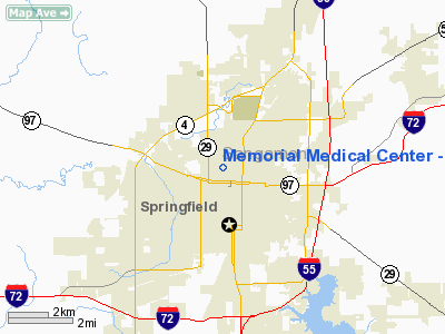
Location
& QuickFacts
|
FAA
Information Effective: |
2007-12-20 |
|
Airport
Identifier: |
54LL |
|
Airport
Status: |
Operational |
|
Longitude/Latitude: |
089-39-18.3600W/39-48-35.1810N
-89.655100/39.809773 (Estimated) |
|
Elevation: |
688 ft / 209.70 m (Surveyed) |
|
Land: |
0 acres |
|
From nearest
city: |
1 nautical miles NW of Springfield, IL |
|
Location: |
Sangamon County, IL |
|
Magnetic
Variation: |
01E (1985) |
Owner
& Manager
|
Ownership: |
Privately
owned |
|
Owner: |
Memorial Medical Center |
|
Address: |
800 N Rutledge Street
Springfield,
IL 62781 |
|
Phone
number: |
217-788-3000 |
|
Manager: |
William Boyd |
|
Address: |
800 N. Rutledge Street
Springfield,
IL 62781 |
|
Phone
number: |
217-788-3000 |
Airport Operations
and Facilities
|
Airport
Use: |
Private
MEDICAL USE. |
|
Wind indicator: |
Yes |
|
Segmented
Circle: |
Yes |
|
Control
Tower: |
No |
|
Lighting
Schedule: |
PHONE REQ
FOR ROTG BCN CALL 217-788-3000. |
|
Beacon
Color: |
Clear-Green (lighted land airport) |
|
Sectional
chart: |
St Louis |
|
Region: |
AGL - Great Lakes |
|
Boundary
ARTCC: |
ZKC - Kansas City |
|
Tie-in
FSS: |
STL - Saint Louis |
|
FSS on
Airport: |
No |
|
FSS Toll
Free: |
1-800-WX-BRIEF |
|
Runway Information
Helipad H1
|
Dimension: |
30 x 30 ft /
9.1 x 9.1 m |
|
Surface: |
CONC,
HELIPAD ON ROOF TOP. |
|
|
Runway H1 |
Runway |
|
Traffic
Pattern: |
Left |
Left |
|
Radio Navigation
Aids
|
ID |
Type |
Name |
Ch |
Freq |
Var |
Dist |
|
SP |
NDB |
Huskk |
|
382.00 |
01W |
5.3 nm |
|
LQ |
NDB |
Licol |
|
375.00 |
01W |
6.6 nm |
|
TAZ |
NDB |
Taylorville |
|
395.00 |
00E |
22.5 nm |
|
AAA |
NDB |
Abraham |
|
329.00 |
00E |
25.6 nm |
|
LTD |
NDB |
Litchfield |
|
371.00 |
01E |
38.7 nm |
|
SYZ |
NDB |
Shelbyville |
|
365.00 |
01E |
44.7 nm |
|
PI |
NDB |
Tungg |
|
356.00 |
01E |
47.9 nm |
|
CTK |
NDB |
Canton |
|
236.00 |
02E |
49.4 nm |
|
IJX |
VOR/DME |
Jacksonville |
023X |
108.60 |
02E |
27.0 nm |
|
SPI |
VORTAC |
Spinner |
74X |
112.70 |
01W |
2.1 nm |
|
CAP |
VORTAC |
Capital |
074X |
112.70 |
04E |
5.1 nm |
|
DEC |
VORTAC |
Decatur |
119X |
117.20 |
03E |
37.2 nm |
|
VLA |
VORTAC |
Vandalia |
090X |
114.30 |
04E |
48.7 nm |
Remarks
- PRVDD
FINAL INGRESS/EGRESS OPNS ARE CONDUCTED ONLY ON BRG OF 090; 140 OR 320
DEG FROM THE HELIPAD USING THE HELIPAD AS THE CENTER OF COMPASS ROSE.
Memorial Medical Center - Springfield
Heliport
Address:
Sangamon County, IL
Tel:
217-788-3000
Images
and information placed above are from
http://www.airport-data.com/airport/54LL/
We
thank them for the data!
| General
Info |
| Country |
United
States |
| State |
ILLINOIS
|
| FAA ID |
54LL |
| Latitude |
39-48-35.181N
|
| Longitude |
089-39-18.360W
|
| Elevation |
688 feet
|
| Near City |
SPRINGFIELD
|
We don't guarantee the information is fresh and accurate. The data may
be wrong or outdated.
For more up-to-date information please refer to other sources.
|
|


