Mc Donough County Hospital Heliport |
 |
|
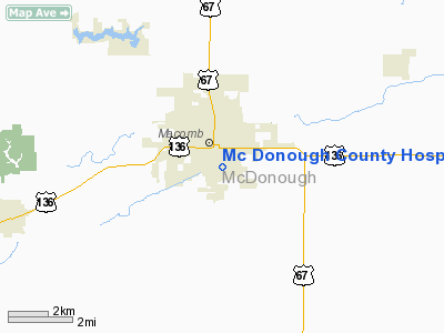
Location
& QuickFacts
|
FAA
Information Effective: |
2007-12-20 |
|
Airport
Identifier: |
46IL |
|
Airport
Status: |
Operational |
|
Longitude/Latitude: |
090-40-00.4690W/40-27-00.1470N
-90.666797/40.450041 (Estimated) |
|
Elevation: |
685 ft / 208.79 m (Estimated) |
|
Land: |
0 acres |
|
From nearest
city: |
0 nautical miles N of Macomb, IL |
|
Location: |
Mc Donough County, IL |
|
Magnetic
Variation: |
02E (1985) |
Owner
& Manager
|
Ownership: |
Publicly
owned |
|
Address: |
|
|
Manager: |
Chris Dace |
|
Address: |
Mc Donough Dist Hospital
Macomb, IL 61445 |
|
Phone
number: |
309-833-4101 |
Airport Operations
and Facilities
|
Airport
Use: |
Private
MEDICAL USE. |
|
Wind indicator: |
Yes |
|
Segmented
Circle: |
No |
|
Control
Tower: |
No |
|
Lighting
Schedule: |
PHONE REQ
FOR ROTG BCN CALL 309-833-4101. |
|
Beacon
Color: |
Clear-Green (lighted land airport) |
|
Landing
fee charge: |
No |
|
Sectional
chart: |
Chicago |
|
Region: |
AGL - Great Lakes |
|
Boundary
ARTCC: |
ZAU - Chicago |
|
Tie-in
FSS: |
IKK - Kankakee |
|
FSS on
Airport: |
No |
|
FSS Toll
Free: |
1-800-WX-BRIEF |
Airport Services
|
Airframe
Repair: |
NONE |
|
Power
Plant Repair: |
NONE |
|
Runway Information
Helipad H1
|
Dimension: |
44 x 44 ft /
13.4 x 13.4 m |
|
Surface: |
CONC, |
|
|
Runway H1 |
Runway |
|
Traffic
Pattern: |
Left |
Left |
|
Radio Navigation
Aids
|
ID |
Type |
Name |
Ch |
Freq |
Var |
Dist |
|
JZY |
NDB |
Macomb |
|
251.00 |
01E |
6.4 nm |
|
CTK |
NDB |
Canton |
|
236.00 |
02E |
27.8 nm |
|
EOK |
NDB |
Keokuk |
|
366.00 |
02E |
35.1 nm |
|
UI |
NDB |
Quincy |
|
293.00 |
02E |
43.3 nm |
|
MPZ |
NDB |
Mount Pleasant |
|
212.00 |
02E |
48.5 nm |
|
PPQ |
NDB |
Pittsfield |
|
344.00 |
02E |
49.0 nm |
|
PI |
NDB |
Tungg |
|
356.00 |
01E |
49.9 nm |
|
GBG |
VOR/DME |
Galesburg |
035X |
109.80 |
03E |
31.1 nm |
|
IJX |
VOR/DME |
Jacksonville |
023X |
108.60 |
02E |
45.0 nm |
|
BRL |
VORTAC |
Burlington |
051X |
111.40 |
05E |
20.2 nm |
|
PIA |
VORTAC |
Peoria |
099X |
115.20 |
04E |
42.2 nm |
|
UIN |
VORTAC |
Quincy |
083X |
113.60 |
05E |
45.8 nm |
Remarks
- HELIPORT
FOR EMERG USE TO TRANSPORT PATIENTS TO OTHER HOSPITALS.
Mc Donough County Hospital Heliport
Address:
Mc Donough County, IL
Tel:
309-833-4101
Images
and information placed above are from
http://www.airport-data.com/airport/46IL/
We
thank them for the data!
| General
Info |
| Country |
United
States |
| State |
ILLINOIS
|
| FAA ID |
46IL |
| Latitude |
40-27-00.147N
|
| Longitude |
090-40-00.469W
|
| Elevation |
685 feet
|
| Near City |
MACOMB
|
We don't guarantee the information is fresh and accurate. The data may
be wrong or outdated.
For more up-to-date information please refer to other sources.
|


