 |
|
Coordinates: 40°31â²12â³N 090°39â²09â³W / 40.52°N 90.6525°W / 40.52; -90.6525
| Macomb Municipal Airport |
| IATA: MQB â ICAO: KMQB â FAA LID: MQB |
| Summary |
| Airport type |
Public |
| Owner |
Macomb Airport Authority |
| Location |
Macomb, Illinois |
| Elevation AMSL |
707 ft / 215 m |
| Runways |
| Direction |
Length |
Surface |
| ft |
m |
| 9/27 |
5,101 |
1,555 |
Asphalt |
| 18/36 |
3,719 |
1,134 |
Turf |
| Statistics (2006) |
| Aircraft operations |
9,000 |
| Based aircraft |
31 |
| Source: Federal Aviation Administration |
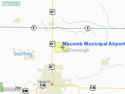
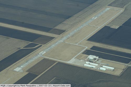
Macomb Municipal Airport (IATA: MQB, ICAO: KMQB, FAA LID: MQB) is a public airport located three statute miles (5 km) north of the central business district of Macomb, a city in McDonough County, Illinois, United States. It is owned by the Macomb Airport Authority.
Facilities and aircraft
Macomb Municipal Airport covers an area of 360 acres (146 ha) which contains two runways: 9/27 with an asphalt pavement measuring 5,100 x 100 ft (1,555 x 30 m) and 18/36 with a turf surface measuring 3,719 x 190 ft (1,134 x 58 m).
For the 12-month period ending December 31, 2006, the airport had 9,000 aircraft operations, an average of 24 per day: 72% general aviation and 28% air taxi. There are 31 aircraft based at this airport: 77% single-engine and 23% multi-engine.
The above content comes from Wikipedia and is published under free licenses – click here to read more.
|
 |
(Click on the photo to enlarge) |
Location
& QuickFacts
|
FAA
Information Effective: |
2007-12-20 |
|
Airport
Identifier: |
MQB |
|
Airport
Status: |
Operational |
|
Longitude/Latitude: |
090-39-08.6000W/40-31-12.3000N
-90.652389/40.520083 (Estimated) |
|
Elevation: |
707 ft / 215.49 m (Surveyed) |
|
Land: |
360 acres |
|
From nearest
city: |
3 nautical miles N of Macomb, IL |
|
Location: |
Mc Donough County, IL |
|
Magnetic
Variation: |
01E (1990) |
Owner
& Manager
|
Ownership: |
Publicly
owned |
|
Owner: |
Macomb Arpt Authority |
|
Address: |
Rr 1-16190 E 1300th St
Macomb, IL 61455 |
|
Phone
number: |
309-833-3324 |
|
Manager: |
Lee Cobb |
|
Address: |
Rr 1-16190 E 1300th St
Macomb, IL 61455 |
|
Phone
number: |
309-833-3324 |
Airport Operations
and Facilities
|
Airport
Use: |
Open
to public |
|
Wind indicator: |
Yes |
|
Segmented
Circle: |
No |
|
Control
Tower: |
No |
|
Lighting
Schedule: |
DUSK-DAWN
HIRL RY 09/27 PRESET ON LOW INTST; TO INCR INTST & ACTVT
REIL RY 27 & TWY LGTS - CTAF. |
|
Beacon
Color: |
Clear-Green (lighted land airport) |
|
Landing
fee charge: |
No |
|
Sectional
chart: |
Chicago |
|
Region: |
AGL - Great Lakes |
|
Traffic
Pattern Alt: |
800 ft |
|
Boundary
ARTCC: |
ZAU - Chicago |
|
Tie-in
FSS: |
IKK - Kankakee |
|
FSS on
Airport: |
No |
|
FSS Toll
Free: |
1-800-WX-BRIEF |
|
NOTAMs
Facility: |
MQB (NOTAM-d service avaliable) |
|
Federal
Agreements: |
NGY |
Airport Communications
|
CTAF: |
122.800 |
|
Unicom: |
122.800
|
Airport
Services
|
Fuel
available: |
100LLA |
|
Airframe
Repair: |
MAJOR |
|
Power
Plant Repair: |
MAJOR |
|
Bottled
Oxygen: |
NONE |
|
Bulk Oxygen: |
NONE |
|
Runway Information
Runway 09/27
|
Dimension: |
5101 x 100
ft / 1554.8 x 30.5 m
TURF WIDTH 200' SOUTH OF INTERSECTION WITH RWY 09/27. |
|
Surface: |
ASPH, Fair Condition |
|
Weight Limit: |
Single wheel: 18000 lbs.
Dual wheel: 21000 lbs. |
|
Edge Lights: |
High |
|
|
Runway 09 |
Runway 27 |
|
Longitude: |
090-39-39.7663W |
090-38-33.7258W |
|
Latitude: |
40-31-10.9166N |
40-31-10.8339N |
|
Elevation: |
706.00 ft |
679.00 ft |
|
Alignment: |
90 |
127 |
|
ILS Type: |
|
LOCALIZER |
|
Traffic
Pattern: |
Left |
Left |
|
Markings: |
Non-precision instrument, Good Condition |
Non-precision instrument, Good Condition |
|
Crossing
Height: |
25.00 ft |
25.00 ft |
|
VASI: |
2-box on left side |
2-box on left side |
|
Visual Glide
Angle: |
3.00° |
3.00° |
|
Runway End
Identifier: |
No |
Yes |
|
Centerline
Lights: |
No |
No |
|
Touchdown
Lights: |
No |
No |
|
Runway 18/36
|
Dimension: |
3719 x 190
ft / 1133.6 x 57.9 m
TURF WIDTH 200' SOUTH OF INTERSECTION WITH RWY 09/27. |
|
Surface: |
TURF, Good Condition |
|
|
Runway 18 |
Runway 36 |
|
Longitude: |
090-39-11.1977W |
090-39-11.2696W |
|
Latitude: |
40-31-32.5378N |
40-30-55.7862N |
|
Elevation: |
691.00 ft |
682.00 ft |
|
Alignment: |
127 |
0 |
|
Traffic
Pattern: |
Left |
Left |
|
Runway End
Identifier: |
No |
No |
|
Centerline
Lights: |
No |
No |
|
Touchdown
Lights: |
No |
No |
|
Obstruction: |
21 ft tree, 971.0 ft from runway, 126 ft left
of centerline, 46:1 slope to clear |
17 ft road, 615.0 ft from runway, 36:1 slope
to clear |
|
Radio Navigation
Aids
|
ID |
Type |
Name |
Ch |
Freq |
Var |
Dist |
|
JZY |
NDB |
Macomb |
|
251.00 |
01E |
4.2 nm |
|
CTK |
NDB |
Canton |
|
236.00 |
02E |
26.4 nm |
|
EOK |
NDB |
Keokuk |
|
366.00 |
02E |
35.9 nm |
|
MPZ |
NDB |
Mount Pleasant |
|
212.00 |
02E |
46.6 nm |
|
UI |
NDB |
Quincy |
|
293.00 |
02E |
47.0 nm |
|
PI |
NDB |
Tungg |
|
356.00 |
01E |
48.6 nm |
|
GBG |
VOR/DME |
Galesburg |
035X |
109.80 |
03E |
27.0 nm |
|
IJX |
VOR/DME |
Jacksonville |
023X |
108.60 |
02E |
48.6 nm |
|
BRL |
VORTAC |
Burlington |
051X |
111.40 |
05E |
17.5 nm |
|
PIA |
VORTAC |
Peoria |
099X |
115.20 |
04E |
40.4 nm |
|
MZV |
VORTAC |
Moline |
091X |
114.40 |
05E |
48.1 nm |
|
UIN |
VORTAC |
Quincy |
083X |
113.60 |
05E |
49.6 nm |
Based Aircraft
|
Aircraft
based on field: |
31 |
|
Single Engine
Airplanes: |
24 |
|
Multi Engine Airplanes: |
7 |
Operational Statistics
Time
Period: 2006-01-01 - 2006-12-31
|
Aircraft
Operations: |
174/Week |
|
Air Taxi: |
27.8% |
|
General Aviation
Local: |
33.3% |
|
General Aviation
Itinerant: |
38.9% |
Macomb Municipal Airport
Address:
Mc Donough County, IL
Tel:
309-833-3324
Images
and information placed above are from
http://www.airport-data.com/airport/MQB/
We
thank them for the data!
| General
Info |
| Country |
United
States |
| State |
ILLINOIS
|
| FAA ID |
MQB |
| Latitude |
40-31-12.300N
|
| Longitude |
090-39-08.600W
|
| Elevation |
707 feet
|
| Near City |
MACOMB
|
We don't guarantee the information is fresh and accurate. The data may
be wrong or outdated.
For more up-to-date information please refer to other sources.
|
|


