 |
|
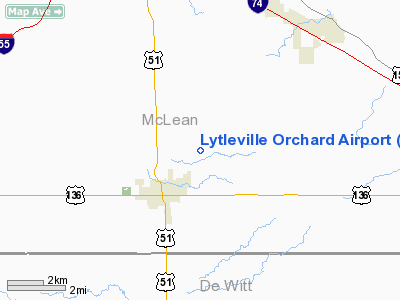
Lytleville Orchard Airport |
Location
& QuickFacts
|
FAA
Information Effective: |
2007-12-20 |
|
Airport
Identifier: |
9IS9 |
|
Airport
Status: |
Operational |
|
Longitude/Latitude: |
088-57-19.2800W/40-20-04.1300N
-88.955356/40.334481 (Estimated) |
|
Elevation: |
785 ft / 239.27 m (Estimated) |
|
Land: |
50 acres |
|
From nearest
city: |
2 nautical miles NE of Heyworth, IL |
|
Location: |
Mc Lean County, IL |
|
Magnetic
Variation: |
01E (1985) |
Owner & Manager
|
Ownership: |
Privately
owned |
|
Owner: |
Lytleville Orchard |
|
Address: |
Rr 1
Heyworth, IL 61745 |
|
Phone
number: |
309-473-2355 |
|
Manager: |
Pierce G. Johnston, Jr. |
|
Address: |
Rr 1
Heyworth, IL 61745 |
|
Phone
number: |
309-473-2355 |
Airport
Operations and Facilities
|
Airport
Use: |
Private |
|
Wind indicator: |
Yes |
|
Segmented
Circle: |
No |
|
Control
Tower: |
No |
|
Sectional
chart: |
Chicago |
|
Region: |
AGL - Great Lakes |
|
Boundary
ARTCC: |
ZAU - Chicago |
|
Tie-in
FSS: |
IKK - Kankakee |
|
FSS Toll
Free: |
1-800-WX-BRIEF |
|
Runway Information
Runway 08/26
|
Dimension: |
2100 x 70 ft
/ 640.1 x 21.3 m |
|
Surface: |
TURF, |
|
|
Runway 08 |
Runway 26 |
|
Traffic
Pattern: |
Left |
Left |
|
Obstruction: |
20 ft trees, 300.0 ft from runway |
|
|
Radio Navigation
Aids
|
ID |
Type |
Name |
Ch |
Freq |
Var |
Dist |
|
AAA |
NDB |
Abraham |
|
329.00 |
00E |
20.4 nm |
|
PI |
NDB |
Tungg |
|
356.00 |
01E |
33.4 nm |
|
LQ |
NDB |
Licol |
|
375.00 |
01W |
39.1 nm |
|
HMJ |
NDB |
Homer |
|
281.00 |
01E |
49.6 nm |
|
BMI |
VOR/DME |
Bloomington |
019X |
108.20 |
03E |
8.9 nm |
|
PNT |
VOR/DME |
Pontiac |
033X |
109.60 |
03E |
31.0 nm |
|
RBS |
VOR/DME |
Roberts |
115X |
116.80 |
02E |
39.1 nm |
|
CMI |
VORTAC |
Champaign |
037X |
110.00 |
03E |
36.0 nm |
|
DEC |
VORTAC |
Decatur |
119X |
117.20 |
03E |
36.2 nm |
|
CAP |
VORTAC |
Capital |
074X |
112.70 |
04E |
40.7 nm |
|
PIA |
VORTAC |
Peoria |
099X |
115.20 |
04E |
43.5 nm |
|
SPI |
VORTAC |
Spinner |
74X |
112.70 |
01W |
44.6 nm |
Remarks
- PRVDD
LETTER OF AGREEMENT BETWEEN JOHNSTON & HAMLON ARPTS SPECIFYING APPROPRIATE
COMPATIBLE TRAFFIC PATTERNS.
Based Aircraft
|
Aircraft
based on field: |
2 |
|
Single Engine
Airplanes: |
2 |
Lytleville Orchard Airport
Address:
Mc Lean County, IL
Tel:
309-473-2355
Images
and information placed above are from
http://www.airport-data.com/airport/9IS9/
We
thank them for the data!
| General
Info |
| Country |
United
States |
| State |
ILLINOIS
|
| FAA ID |
9IS9 |
| Latitude |
40-20-04.130N
|
| Longitude |
088-57-19.280W
|
| Elevation |
785 feet
|
| Near City |
HEYWORTH
|
We don't guarantee the information is fresh and accurate. The data may
be wrong or outdated.
For more up-to-date information please refer to other sources.
|
|


