 |
|
| Logan County Airport |
| IATA: none – ICAO: KAAA – FAA LID: AAA |
| Summary |
| Airport type |
Public |
| Owner |
Logan County Board |
| Location |
Lincoln, Illinois |
| Elevation AMSL |
597 ft / 182 m |
| Coordinates |
40°09′31″N 089°20′06″W / 40.15861°N 89.335°W / 40.15861; -89.335 |
| Runways |
| Direction |
Length |
Surface |
| ft |
m |
| 3/21 |
3,999 |
1,219 |
Asphalt |
| 14/32 |
3,003 |
915 |
Turf |
| Statistics (2006) |
| Aircraft operations |
7,000 |
| Based aircraft |
34 |
| Source: Federal Aviation Administration |
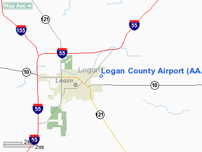
Logan County Airport (ICAO: KAAA, FAA LID: AAA) is a public use airport located nautical miles (4 km) northeast of the central business district of Lincoln, a city in Logan County, Illinois, United States. It is owned by the Logan County Board. The airport is also the site of the National Weather Service Central Illinois.
Although most U.S. airports use the same three-letter location identifier for the FAA and IATA, this airport is assigned AAA by the FAA but has no designation from the IATA (which assigned AAA to Anaa Airport in Anaa, French Polynesia). Facilities and aircraft
Logan County Airport covers an area of 218 acres (88 ha) at an elevation of 597 feet (182 m) above mean sea level. It has two runways: 3/21 with an asphalt pavement measuring 3,999 x 75 ft (1,219 x 23 m) and 14/32 with a turf surface measuring 3,003 x 135 ft (915 x 41 m).
For the 12-month period ending December 31, 2006, the airport had 7,000 aircraft operations, an average of 19 per day: 80% general aviation, 19% air taxi and 1% military. At that time there were 34 aircraft based at this airport: 82% single-engine, 15% multi-engine, and 3% helicopter.
The above content comes from Wikipedia and is published under free licenses – click here to read more.
Location
& QuickFacts
|
FAA
Information Effective: |
2007-12-20 |
|
Airport
Identifier: |
AAA |
|
Airport
Status: |
Operational |
|
Longitude/Latitude: |
089-20-06.1000W/40-09-31.3000N
-89.335028/40.158694 (Estimated) |
|
Elevation: |
597 ft / 181.97 m (Surveyed) |
|
Land: |
218 acres |
|
From
nearest city: |
2 nautical miles NE of Lincoln, IL |
|
Location: |
Logan County, IL |
|
Magnetic Variation: |
00E (1990) |
Owner
& Manager
|
Ownership: |
Publicly
owned |
|
Owner: |
Logan County Board |
|
Address: |
County Courthouse
Lincoln, IL 62656 |
|
Phone
number: |
217-732-6400 |
|
Manager: |
Bill Sahs |
|
Address: |
P.o. Box 278
Lincoln, IL 62656 |
|
Phone number: |
217-732-6400 |
Airport Operations and Facilities
|
Airport
Use: |
Open
to public |
|
Wind
indicator: |
Yes |
|
Segmented Circle: |
No |
|
Control
Tower: |
No |
|
Lighting
Schedule: |
DUSK-DAWN
ACTVT MIRL RY 03/21 - CTAF. |
|
Beacon
Color: |
Clear-Green (lighted land airport) |
|
Landing
fee charge: |
No |
|
Sectional chart: |
Chicago |
|
Region: |
AGL - Great Lakes |
|
Boundary
ARTCC: |
ZAU - Chicago |
|
Responsible ARTCC: |
ZKC - Kansas City |
|
Tie-in
FSS: |
STL - Saint Louis |
|
FSS
on Airport: |
No |
|
FSS
Toll Free: |
1-800-WX-BRIEF |
|
NOTAMs
Facility: |
AAA (NOTAM-d service avaliable) |
|
Federal Agreements: |
NGY |
Airport Communications
|
CTAF: |
122.800 |
|
Unicom: |
122.800
|
Airport
Services
|
Fuel
available: |
100
SELF SERVE FUEL AVBL 24 HRS. |
|
Airframe
Repair: |
MAJOR |
|
Power
Plant Repair: |
MAJOR |
|
Bottled
Oxygen: |
NONE |
|
Bulk
Oxygen: |
NONE |
|
Runway Information
Runway 03/21
|
Dimension: |
3999 x 75 ft / 1218.9 x 22.9 m
HAS 225 FT STWY NE END. |
|
Surface: |
ASPH, Good Condition |
|
Weight
Limit: |
Single wheel: 12500 lbs. |
|
Edge
Lights: |
Medium |
|
|
Runway 03 |
Runway 21 |
|
Longitude: |
089-20-23.8659W |
089-19-54.1177W |
|
Latitude: |
40-09-11.9179N |
40-09-44.1739N |
|
Elevation: |
592.00 ft |
594.00 ft |
|
Alignment: |
35 |
127 |
|
Traffic
Pattern: |
Left |
Left |
|
Markings: |
Non-precision instrument, Good Condition
03/21 MARKINGS FADED. |
Non-precision instrument, Good Condition |
|
VASI: |
pulsating/steady burning on left side |
pulsating/steady burning on left side |
|
Runway
End Identifier: |
Yes |
No |
|
Centerline
Lights: |
No |
No |
|
Touchdown
Lights: |
No |
No |
|
Obstruction: |
93 ft bldg, 2194.0 ft from runway, 207 ft right
of centerline, 21:1 slope to clear |
42 ft tree, 955.0 ft from runway, 320 ft right
of centerline, 17:1 slope to clear |
|
Runway 14/32
|
Dimension: |
3003 x 135 ft / 915.3 x 41.1 m
HAS 225 FT STWY NE END. |
|
Surface: |
TURF, Good Condition |
|
|
Runway 14 |
Runway 32 |
|
Longitude: |
089-20-13.4331W |
089-19-50.9393W |
|
Latitude: |
40-09-47.7268N |
40-09-23.5861N |
|
Elevation: |
591.00 ft |
589.00 ft |
|
Alignment: |
127 |
127 |
|
Traffic
Pattern: |
Left |
Left |
|
Displaced
threshold: |
307.00 ft |
0.00 ft |
|
Runway
End Identifier: |
No |
No |
|
Centerline
Lights: |
No |
No |
|
Touchdown
Lights: |
No |
No |
|
Obstruction: |
65 ft trees, 1233.0 ft from runway, 219 ft
right of centerline, 18:1 slope to clear
APP SLOPE TO DSPLCD THRESHOLD ON RWY 14 IS 23:1. |
13 ft road, 260.0 ft from runway, 148 ft right
of centerline, 20:1 slope to clear |
|
Radio Navigation
Aids
|
ID |
Type |
Name |
Ch |
Freq |
Var |
Dist |
|
AAA |
NDB |
Abraham |
|
329.00 |
00E |
0.2 nm |
|
LQ |
NDB |
Licol |
|
375.00 |
01W |
19.3 nm |
|
PI |
NDB |
Tungg |
|
356.00 |
01E |
29.4 nm |
|
SP |
NDB |
Huskk |
|
382.00 |
01W |
30.3 nm |
|
TAZ |
NDB |
Taylorville |
|
395.00 |
00E |
37.4 nm |
|
CTK |
NDB |
Canton |
|
236.00 |
02E |
41.9 nm |
|
BMI |
VOR/DME |
Bloomington |
019X |
108.20 |
03E |
26.8 nm |
|
IJX |
VOR/DME |
Jacksonville |
023X |
108.60 |
02E |
47.6 nm |
|
PNT |
VOR/DME |
Pontiac |
033X |
109.60 |
03E |
48.4 nm |
|
CAP |
VORTAC |
Capital |
074X |
112.70 |
04E |
20.9 nm |
|
SPI |
VORTAC |
Spinner |
74X |
112.70 |
01W |
24.8 nm |
|
DEC |
VORTAC |
Decatur |
119X |
117.20 |
03E |
33.6 nm |
|
PIA |
VORTAC |
Peoria |
099X |
115.20 |
04E |
37.7 nm |
|
CMI |
VORTAC |
Champaign |
037X |
110.00 |
03E |
49.3 nm |
Based Aircraft
|
Aircraft
based on field: |
32 |
|
Single
Engine Airplanes: |
30 |
|
Multi
Engine Airplanes: |
2 |
Operational Statistics
Time Period: 2006-01-01 - 2006-12-31
|
Aircraft
Operations: |
135/Week |
|
Air
Taxi: |
18.6% |
|
General
Aviation Local: |
40.0% |
|
General
Aviation Itinerant: |
40.0% |
|
Military: |
1.4% |
Logan County Airport
Address:
Logan County, IL
Tel:
217-732-6400
Images
and information placed above are from
http://www.airport-data.com/airport/AAA/
We
thank them for the data!
| General
Info |
| Country |
United
States |
| State |
ILLINOIS
|
| FAA ID |
AAA |
| Latitude |
40-09-31.300N
|
| Longitude |
089-20-06.100W
|
| Elevation |
597 feet
|
| Near City |
LINCOLN
|
We don't guarantee the information is fresh and accurate. The data may
be wrong or outdated.
For more up-to-date information please refer to other sources.
|
|


