 |
|
Lansing Municipal Airport |
Coordinates: 41°32â²06â³N 087°31â²46â³W / 41.535°N 87.52944°W / 41.535; -87.52944
| Lansing Municipal Airport |
| IATA: none â ICAO: KIGQ â FAA LID: IGQ |
| Summary |
| Airport type |
Public |
| Owner |
Village of Lansing |
| Serves |
Chicago, Illinois |
| Location |
Lansing, Illinois |
| Elevation AMSL |
620 ft / 189 m |
| Runways |
| Direction |
Length |
Surface |
| ft |
m |
| 9/27 |
3,395 |
1,035 |
Asphalt |
| 18/36 |
4,002 |
1,220 |
Asphalt |
| Statistics (2004) |
| Aircraft operations |
54,000 |
| Based aircraft |
173 |
| Source: Federal Aviation Administration |
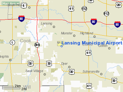
Lansing Municipal Airport (ICAO: KIGQ, FAA LID: IGQ) is a public airport located 21 miles (34 km) south of Chicago, in Lansing, a village in Cook County, Illinois, USA. It is owned by the Village of Lansing.
Although most U.S. airports use the same three-letter location identifier for the FAA and IATA, Lansing Municipal Airport is assigned IGQ by the FAA but has no designation from the IATA. Facilities and aircraft
Lansing Municipal Airport covers an area of 560 acres (227 ha) which contains two asphalt paved runways: 9/27 measuring 3,395 x 75 ft (1,035 x 23 m) and 18/36: 4,002 x 75 ft (1,220 x 23 m). It also houses a blimp base which launches 1/4 of the blimps that cover Chicago sporting events.
For the 12-month period ending December 31, 2004, the airport had 54,000 aircraft operations, an average of 147 per day: 91% general aviation and 9% air taxi. There are 173 aircraft based at this airport: 81% single engine, 9% multi-engine, 3% jet, 3% helicopter, 2% ultralight. and 2% blimp
Incidents
- On July 24, 1966, a Beechcraft Bonanza bound for Lansing Municipal Airport crashed on a nearby golf course. The pilot and all three passengers were killed. On board the plane was professional golfer Tony Lema and his wife.
- On October 14, 2004, a Cessna 172 inbound for Runway 27, at 5:57 a.m., fell short due to bad weather and poor visibility. Nobody was injured.
- On March 9, 2007 a small plane crashed after takeoff from the airport at 7:30 pm. 2 people died. The plane crashed on Calumet Avenue in Munster, Indiana about 1 mile (1.6 km) away from the airport.
The above content comes from Wikipedia and is published under free licenses – click here to read more.
|
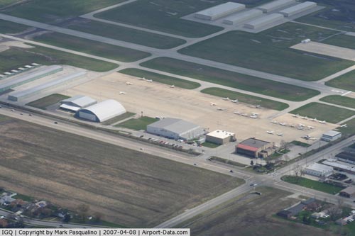 |
(Click on the photo to enlarge) |
Location
& QuickFacts
|
FAA
Information Effective: |
2007-12-20 |
|
Airport
Identifier: |
IGQ |
|
Airport
Status: |
Operational |
|
Longitude/Latitude: |
087-31-46.3000W/41-32-05.7000N
-87.529528/41.534917 (Estimated) |
|
Elevation: |
620 ft / 188.98 m (Surveyed) |
|
Land: |
560 acres |
|
From
nearest city: |
21 nautical miles S of Chicago, IL |
|
Location: |
Cook County, IL |
|
Magnetic Variation: |
02W (1995) |
Owner & Manager
|
Ownership: |
Publicly owned |
|
Owner: |
Village Of Lansing |
|
Address: |
18200 Chicago Ave
Lansing, IL 60438 |
|
Phone number: |
708-895-7208 |
|
Manager: |
Robert Malkas |
|
Address: |
194th & Burnham
Lansing, IL 60438 |
|
Phone number: |
708-895-8844
ALSO PHONE
708-895-8847. |
Airport
Operations and Facilities
|
Airport
Use: |
Open
to public |
|
Wind
indicator: |
Yes |
|
Segmented Circle: |
No |
|
Control
Tower: |
No |
|
Lighting
Schedule: |
DUSK-DAWN
MIRL RY 18/36 PRESET ON LOW INTST; TO INCR INTST & ACTVT
MIRL RY 09/27, REILS RY 09, 18, 27 & 36, TXWY LIGHTS
- CTAF. |
|
Beacon
Color: |
Clear-Green (lighted land airport) |
|
Landing
fee charge: |
No |
|
Sectional chart: |
Chicago |
|
Region: |
AGL - Great Lakes |
|
Traffic
Pattern Alt: |
1000 ft |
|
Boundary
ARTCC: |
ZAU - Chicago |
|
Tie-in
FSS: |
IKK - Kankakee |
|
FSS
on Airport: |
No |
|
FSS
Toll Free: |
1-800-WX-BRIEF |
|
NOTAMs
Facility: |
IGQ (NOTAM-d service avaliable) |
|
Federal Agreements: |
NGY |
Airport Communications
|
CTAF: |
122.700 |
|
Unicom: |
122.700
|
Airport
Services
|
Fuel
available: |
100LLA |
|
Airframe
Repair: |
MAJOR |
|
Power
Plant Repair: |
MAJOR |
|
Bottled
Oxygen: |
HIGH/LOW |
|
Bulk
Oxygen: |
HIGH/LOW |
|
Runway Information
Runway 09/27
|
Dimension: |
3395 x 75 ft / 1034.8 x 22.9 m
RY 09 THRS WAS RELOCATED - DSPLCD THLD IS NOW TWY. |
|
Surface: |
ASPH-TRTD, Good Condition |
|
Surface
Treatment: |
Porous Friction Course |
|
Weight
Limit: |
Single wheel: 12500 lbs. |
|
Edge
Lights: |
Medium |
|
|
Runway 09 |
Runway 27 |
|
Longitude: |
087-32-16.4400W |
087-31-31.7900W |
|
Latitude: |
41-32-23.6300N |
41-32-23.5300N |
|
Elevation: |
614.00 ft |
617.00 ft |
|
Alignment: |
90 |
127 |
|
Traffic
Pattern: |
Left |
Left |
|
Markings: |
Basic, Good Condition |
Non-precision instrument, Good Condition |
|
Crossing
Height: |
40.00 ft |
40.00 ft |
|
VASI: |
2-light PAPI on left side |
2-light PAPI on left side |
|
Visual
Glide Angle: |
3.00° |
3.00° |
|
Runway
End Identifier: |
Yes |
Yes |
|
Obstruction: |
24 ft tree, 477.0 ft from runway, 222 ft left
of centerline, 10:1 slope to clear |
146 ft tower, 4325.0 ft from runway, 665 ft
right of centerline, 28:1 slope to clear |
|
Runway 18/36
|
Dimension: |
4002 x 75 ft / 1219.8 x 22.9 m
RY 09 THRS WAS RELOCATED - DSPLCD THLD IS NOW TWY. |
|
Surface: |
ASPH-TRTD, Good Condition |
|
Surface
Treatment: |
Porous Friction Course |
|
Weight
Limit: |
Single wheel: 24000 lbs. |
|
Edge
Lights: |
Medium |
|
|
Runway 18 |
Runway 36 |
|
Longitude: |
087-31-39.5900W |
087-31-39.7200W |
|
Latitude: |
41-32-10.2500N |
41-31-30.7100N |
|
Elevation: |
617.00 ft |
618.00 ft |
|
Alignment: |
127 |
0 |
|
ILS
Type: |
|
LOC/DME |
|
Traffic
Pattern: |
Left |
Left |
|
Markings: |
Non-precision instrument, Good Condition |
Non-precision instrument, Good Condition |
|
Crossing
Height: |
40.00 ft |
40.00 ft |
|
VASI: |
2-light PAPI on left side |
2-light PAPI on left side |
|
Visual
Glide Angle: |
3.00° |
3.00° |
|
Runway
End Identifier: |
Yes |
Yes |
|
Obstruction: |
120 ft tower, 4987.0 ft from runway, 38 ft
right of centerline, 39:1 slope to clear |
, 50:1 slope to clear |
|
Radio Navigation
Aids
|
ID |
Type |
Name |
Ch |
Freq |
Var |
Dist |
|
MX |
NDB |
Kedzi |
|
248.00 |
01W |
14.4
nm |
|
HK |
NDB |
Ermin |
|
332.00 |
01W |
17.7
nm |
|
VP |
NDB |
Sedly |
|
212.00 |
02W |
29.8
nm |
|
MGC |
NDB |
Michigan
City |
|
203.00 |
01W |
33.7
nm |
|
IUL |
NDB |
La
Porte |
|
356.00 |
03W |
34.2
nm |
|
ME |
NDB |
Deana |
|
350.00 |
00E |
34.3
nm |
|
RZL |
NDB |
Rensselaer |
|
362.00 |
02W |
38.6
nm |
|
RWN |
NDB |
Winamac/dcmsnd |
|
335.00 |
00W |
49.5
nm |
|
IKK |
VOR/DME |
Kankakee |
053X |
111.60 |
00E |
31.2
nm |
|
ORD |
VOR/DME |
Chicago
O'hare |
086X |
113.90 |
02E |
32.0
nm |
|
OXI |
VOR/DME |
Knox |
103X |
115.60 |
00E |
41.7
nm |
|
DPA |
VOR/DME |
Dupage |
021X |
108.40 |
02E |
42.6
nm |
|
OBK |
VOR/DME |
Northbrook |
077X |
113.00 |
02W |
45.4
nm |
|
CGT |
VORTAC |
Chicago
Heights |
089X |
114.20 |
02E |
2.4
nm |
|
EON |
VORTAC |
Peotone |
079X |
113.20 |
02E |
19.8
nm |
|
JOT |
VORTAC |
Joliet |
070X |
112.30 |
02E |
35.5
nm |
|
MDW |
VOT |
Chicago
Midway |
|
111.00 |
|
18.1
nm |
|
ORD |
VOT |
Chicago
O'hare Intl |
|
112.00 |
|
31.8
nm |
Remarks
- ALL
PATTERN FLYING IN NOISE SENSITIVE AREA.
- BIRDS
ON & INVOF ARPT.
- 146
FT TOWER 4325 FT FROM RY 27 665 FT RIGHT OF EXTENDED CNTRLN.
- EXISTED
PRIOR TO 1959.
Based
Aircraft
|
Aircraft
based on field: |
173 |
|
Single
Engine Airplanes: |
141 |
|
Multi
Engine Airplanes: |
15 |
|
Jet
Engine Airplanes: |
8 |
|
Helicopters: |
7 |
|
Ultralights: |
2 |
Operational Statistics
Time Period: 2004-01-02 - 2004-12-31
|
Aircraft
Operations: |
148/Day |
|
Air
Taxi: |
9.3% |
|
General
Aviation Local: |
50.0% |
|
General
Aviation Itinerant: |
40.7% |
Lansing Municipal Airport
Address:
Cook County, IL
Tel:
708-895-7208,
708-895-8844
Images
and information placed above are from
http://www.airport-data.com/airport/IGQ/
We
thank them for the data!
| General
Info |
| Country |
United
States |
| State |
ILLINOIS
|
| FAA ID |
IGQ |
| Latitude |
41-32-23.600N
|
| Longitude |
087-31-55.800W
|
| Elevation |
616 feet
|
| Near City |
CHICAGO
|
We don't guarantee the information is fresh and accurate. The data may
be wrong or outdated.
For more up-to-date information please refer to other sources.
|
|


