 |
|
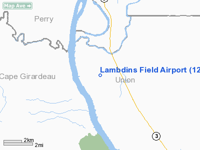
Location
& QuickFacts
|
FAA
Information Effective: |
2007-12-20 |
|
Airport
Identifier: |
12LL |
|
Airport
Status: |
Operational |
|
Longitude/Latitude: |
089-29-10.3450W/37-32-25.1770N
-89.486207/37.540327 (Estimated) |
|
Elevation: |
350 ft / 106.68 m (Estimated) |
|
Land: |
0 acres |
|
From
nearest city: |
3 nautical miles NW of Wolf Lake, IL |
|
Location: |
Union County, IL |
|
Magnetic Variation: |
01E (1985) |
Owner
& Manager
|
Ownership: |
Privately
owned |
|
Owner: |
Charles Lambdin |
|
Address: |
1005 Galilee Rd
Wolf Lake, IL 62998 |
|
Phone
number: |
618-833-9265 |
|
Manager: |
Charles Lambdin |
|
Address: |
1005 Galilee Rd
Wolf Lake, IL 62998 |
|
Phone number: |
618-833-9265 |
Airport Operations and Facilities
|
Airport Use: |
Private |
|
Wind indicator: |
Yes |
|
Segmented Circle: |
No |
|
Control Tower: |
No |
|
Landing fee charge: |
No |
|
Sectional chart: |
St Louis |
|
Region: |
AGL - Great Lakes |
|
Boundary ARTCC: |
ZKC - Kansas City |
|
Tie-in FSS: |
COU - Columbia |
|
FSS on Airport: |
No |
|
FSS Toll Free: |
1-800-WX-BRIEF |
Airport Services
|
Airframe
Repair: |
NONE |
|
Power
Plant Repair: |
NONE |
|
Runway Information
Runway 09/27
|
Dimension: |
2200
x 120 ft / 670.6 x 36.6 m |
|
Surface: |
TURF, |
|
|
Runway 09 |
Runway 27 |
|
Traffic
Pattern: |
Left |
Left |
|
Radio Navigation
Aids
|
ID |
Type |
Name |
Ch |
Freq |
Var |
Dist |
|
PJY |
NDB |
Pinckneyville |
|
215.00 |
00E |
26.8
nm |
|
CIR |
NDB |
Cairo |
|
397.00 |
00E |
31.4
nm |
|
SAR |
NDB |
Sparta |
|
239.00 |
01E |
37.8
nm |
|
CHQ |
NDB |
Charleston |
|
208.00 |
01E |
42.2
nm |
|
BDD |
NDB |
Bellgrade |
|
254.00 |
00E |
45.6
nm |
|
PRI |
NDB |
Perrine |
|
367.00 |
02E |
46.9
nm |
|
HSB |
NDB |
Harrisburg-raleigh |
|
230.00 |
00E |
47.6
nm |
|
CGI |
VOR/DME |
Cape
Girardeau |
076X |
112.90 |
01E |
19.2
nm |
|
MWA |
VOR/DME |
Marion |
041X |
110.40 |
04E |
26.0
nm |
|
FAM |
VORTAC |
Farmington |
104X |
115.70 |
01E |
36.5
nm |
|
CNG |
VORTAC |
Cunningham |
078X |
113.10 |
03E |
44.6
nm |
Remarks
- PRVDD
OBSTNS IN RY APCH SLOPE REMOVED/LOWERED OR RY THLD DSPLCD & MKD
TO PRVD 20:1 APCH CLNC OVER OBSTNS & AREA 125 FT EA SIDE OF RY CNTRLN
& 200 FT OFF RY ENDS CLEAR OF ANY OBSTNS.
Based
Aircraft
|
Aircraft
based on field: |
1 |
|
Single
Engine Airplanes: |
1 |
Lambdins Field Airport
Address:
Union County, IL
Tel:
618-833-9265
Images
and information placed above are from
http://www.airport-data.com/airport/12LL/
We
thank them for the data!
| General
Info |
| Country |
United
States |
| State |
ILLINOIS
|
| FAA ID |
12LL |
| Latitude |
37-32-25.177N
|
| Longitude |
089-29-10.345W
|
| Elevation |
350 feet
|
| Near City |
WOLF LAKE
|
We don't guarantee the information is fresh and accurate. The data may
be wrong or outdated.
For more up-to-date information please refer to other sources.
|
|


