 |
|
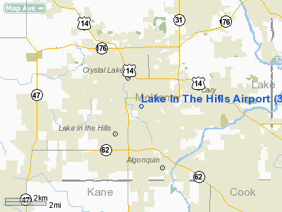
Lake In The Hills Airport |
Coordinates: 42°12â²24â³N 088°19â²23â³W / 42.20667°N 88.32306°W / 42.20667; -88.32306
| Lake in the Hills Airport |
| IATA: none â ICAO: none â FAA LID: 3CK |
| Summary |
| Airport type |
Public |
| Owner |
Village of Lake in the Hills |
| Location |
Lake in the Hills, Illinois |
| Elevation AMSL |
888 ft / 271 m |
| Website |
www.lith.org |
| Runways |
| Direction |
Length |
Surface |
| ft |
m |
| 8/26 |
3,801 |
1,159 |
Asphalt |
| Statistics (2006) |
| Aircraft operations |
34,000 |
| Based aircraft |
131 |
| Source: FAA and airport web site |
Lake in the Hills Airport (FAA LID: 3CK) is a public airport located at 8407 Pyott Road in Lake in the Hills, a village in McHenry County, Illinois, United States. The airport is owned by the Village of Lake in the Hills and is located 38 miles (61 km) northwest of the central business district of Chicago. It is a designated Federal Aviation Administration reliever airport for Chicago's O'Hare International Airport. Facilities and aircraft
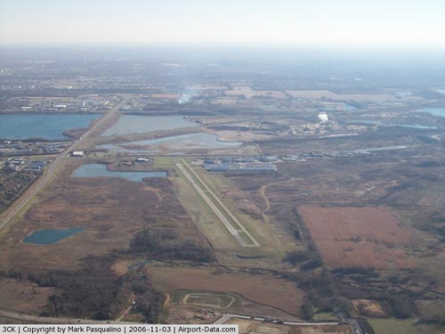
Lake in the Hills Airport covers an area of 155 acres (63 ha) at an elevation of 888 ft (271 m). It contains one runway designated 8/26 with a 3,801 x 50 ft (1,159 x 15 m) asphalt pavement. The airport is uncontrolled and is open to the public.
For the 12-month period ending December 31, 2006, the airport had 34,000 general aviation aircraft operations, an average of 93 per day. There are 131 aircraft based at this airport: 90% single-engine, 6% multi-engine, 2% jet and 2% helicopter.
FBO services are provided by Northern Illinois Flight Center. FBO offers 100LL and Jet A fuel.
Redevelopment Program
During 2008-2012, the airport is undergoing major renovation. Pyott Road to the east has been relocated to create an improved Runway Safety Area. A new parallel taxiway is now under construction that will be capable of operating as a temporary runway. The existing runway will be doubled in width to 100 feet (30 m). A larger primary aircraft parking apron and new general aviation terminal will be constructed. Improvements wil also be made to drainage, utilities and support facilities. Because of continued success in advancing this safety improvement program, the airport was named 2010 Reliever Airport of the Year in Illinois by the Illinois Division of Aeronautics.
The above content comes from Wikipedia and is published under free licenses – click here to read more.
|
 |
(Click on the photo to enlarge) |
Location
& QuickFacts
|
FAA
Information Effective: |
2007-12-20 |
|
Airport
Identifier: |
3CK |
|
Airport
Status: |
Operational |
|
Longitude/Latitude: |
088-19-22.9450W/42-12-24.4910N
-88.323040/42.206803 (Estimated) |
|
Elevation: |
888 ft / 270.66 m (Surveyed) |
|
Land: |
72 acres |
|
From
nearest city: |
38 nautical miles NW of Chicago/lake In The
Hills, IL |
|
Location: |
Mc Henry County, IL |
|
Magnetic Variation: |
02W (2000) |
Owner
& Manager
|
Ownership: |
Publicly
owned |
|
Owner: |
Village Of Lake In The Hills |
|
Address: |
600 Harvest Gate
Lake In The Hills, IL 60156 |
|
Phone
number: |
847-960-7400 |
|
Manager: |
Dave Gregoria |
|
Address: |
8407 Pyott Road
Lake In The Hills, IL 60156 |
|
Phone number: |
847-960-7500 |
Airport Operations and Facilities
|
Airport
Use: |
Open
to public |
|
Wind
indicator: |
Yes |
|
Segmented Circle: |
No |
|
Control
Tower: |
No |
|
Lighting
Schedule: |
SS-SR
ACTVT REIL RY 08, PAPI RY 08 & 26 - 122.75. |
|
Beacon
Color: |
Clear-Green (lighted land airport) |
|
Landing
fee charge: |
No |
|
Sectional chart: |
Chicago |
|
Region: |
AGL - Great Lakes |
|
Traffic
Pattern Alt: |
1000 ft |
|
Boundary
ARTCC: |
ZAU - Chicago |
|
Tie-in
FSS: |
IKK - Kankakee |
|
FSS
on Airport: |
No |
|
FSS
Toll Free: |
1-800-WX-BRIEF |
|
NOTAMs
Facility: |
IKK (NOTAM-d service avaliable) |
|
Federal Agreements: |
N |
Airport Communications
|
CTAF: |
123.050 |
|
Unicom: |
123.050
WIND SPEED & DIRECTION INFO BROADCAST ON UNICOM IS INACCURATE. |
Airport
Services
|
Fuel
available: |
100LLA |
|
Airframe
Repair: |
MAJOR |
|
Power
Plant Repair: |
MAJOR |
|
Bottled
Oxygen: |
HIGH/LOW |
|
Bulk
Oxygen: |
HIGH/LOW |
|
Runway Information
Runway 08/26
|
Dimension: |
3058
x 50 ft / 932.1 x 15.2 m |
|
Surface: |
ASPH, Good Condition |
|
Edge
Lights: |
Medium |
|
|
Runway 08 |
Runway 26 |
|
Longitude: |
088-19-42.9320W |
088-19-02.9580W |
|
Latitude: |
42-12-21.7940N |
42-12-27.1870N |
|
Elevation: |
886.00 ft |
886.00 ft |
|
Alignment: |
80 |
127 |
|
Traffic
Pattern: |
Left |
Left |
|
Markings: |
Basic, Good Condition |
Basic, Good Condition |
|
Crossing
Height: |
20.00 ft |
20.00 ft |
|
VASI: |
2-light PAPI on left side |
2-light PAPI on right side |
|
Visual
Glide Angle: |
3.00° |
3.00° |
|
Runway
End Identifier: |
Yes |
|
|
Centerline
Lights: |
No |
No |
|
Touchdown
Lights: |
No |
No |
|
Obstruction: |
60 ft trees, 1560.0 ft from runway, 100 ft
right of centerline, 22:1 slope to clear |
30 ft pole, 430.0 ft from runway, 239 ft left
of centerline, 7:1 slope to clear
+11' BLDG 130' 263' L. |
|
Radio Navigation
Aids
|
ID |
Type |
Name |
Ch |
Freq |
Var |
Dist |
|
ME |
NDB |
Deana |
|
350.00 |
00E |
19.5
nm |
|
DKB |
NDB |
Dekalb |
|
209.00 |
02W |
23.7
nm |
|
LVV |
NDB |
Lake
Lawn |
|
404.00 |
00W |
31.9
nm |
|
RA |
NDB |
Paser |
|
206.00 |
00E |
34.2
nm |
|
HK |
NDB |
Ermin |
|
332.00 |
01W |
36.5
nm |
|
MX |
NDB |
Kedzi |
|
248.00 |
01W |
39.8
nm |
|
JVL |
NDB |
Janesville |
|
375.00 |
03E |
40.2
nm |
|
GM |
NDB |
Teels |
|
242.00 |
02W |
44.0
nm |
|
OBK |
VOR/DME |
Northbrook |
077X |
113.00 |
02W |
16.6
nm |
|
DPA |
VOR/DME |
Dupage |
021X |
108.40 |
02E |
19.1
nm |
|
ORD |
VOR/DME |
Chicago
O'hare |
086X |
113.90 |
02E |
22.8
nm |
|
BUU |
VOR/DME |
Burbun |
092X |
114.50 |
01W |
29.0
nm |
|
ENW |
VOR/DME |
Kenosha |
029X |
109.20 |
02W |
29.3
nm |
|
RFD |
VOR/DME |
Rockford |
045X |
110.80 |
01E |
39.0
nm |
|
HRK |
VOR/DME |
Horlick |
124X |
117.70 |
02W |
40.3
nm |
|
JVL |
VOR/DME |
Janesville |
090X |
114.30 |
03E |
40.6
nm |
|
JOT |
VORTAC |
Joliet |
070X |
112.30 |
02E |
39.7
nm |
|
ORD |
VOT |
Chicago
O'hare Intl |
|
112.00 |
|
22.9
nm |
|
MDW |
VOT |
Chicago
Midway |
|
111.00 |
|
35.9
nm |
|
MKE |
VOT |
Milwaukee |
|
109.00 |
|
48.4
nm |
Remarks
- NUMEROUS
DEER INVOF OF RY 08/26.
NUMEROUS GEESE INVOF ARPT.
- ACFT
WITH WINGSPAN GREATER THAN 56 FT CANNOT USE PARALLEL TWY.
- ACFT
WITH WINGSPAN GREATER THAN 45.5 FT CANNOT USE PARALLEL TWY EAST OF TWY
BRAVO
- FOR
VFR WX ADVISORY 5 CLICKS CTAF. PHONE
815-444-1729
Based
Aircraft
|
Aircraft
based on field: |
131 |
|
Single
Engine Airplanes: |
118 |
|
Multi
Engine Airplanes: |
8 |
|
Jet
Engine Airplanes: |
3 |
|
Helicopters: |
2 |
Operational Statistics
Time Period: 2006-01-01 - 2006-12-31
|
Aircraft
Operations: |
94/Day |
|
General
Aviation Local: |
44.1% |
|
General
Aviation Itinerant: |
55.9% |
Lake In The Hills Airport
Address:
Mc Henry County, IL
Tel:
847-960-7400,
847-960-7500
Images
and information placed above are from
http://www.airport-data.com/airport/3CK/
We
thank them for the data!
| General
Info |
| Country |
United
States |
| State |
ILLINOIS
|
| FAA ID |
3CK |
| Latitude |
42-12-24.491N
|
| Longitude |
088-19-22.945W
|
| Elevation |
888 feet
|
| Near City |
CHICAGO/LAKE
IN THE HILLS |
We don't guarantee the information is fresh and accurate. The data may
be wrong or outdated.
For more up-to-date information please refer to other sources.
|
|


