 |
|
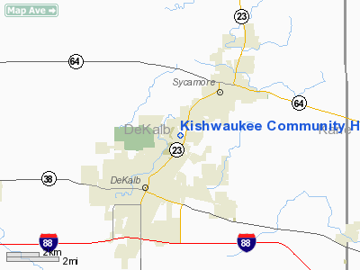
Kishwaukee Community Hospital Heliport |
|
|
Location
& QuickFacts
|
FAA
Information Effective: |
2007-12-20 |
|
Airport
Identifier: |
0IL6 |
|
Airport
Status: |
Operational |
|
Longitude/Latitude: |
088-43-28.0000W/41-57-38.0000N
-88.724444/41.960556 (Estimated) |
|
Elevation: |
852 ft / 259.69 m (Estimated) |
|
Land: |
0 acres |
|
From
nearest city: |
3 nautical miles NE of De Kalb, IL |
|
Location: |
De Kalb County, IL |
|
Magnetic Variation: |
00W (1985) |
Owner
& Manager
|
Ownership: |
Privately
owned |
|
Owner: |
Kishwaukee Health System |
|
Address: |
P.o. Box 707
Dekalb, IL 60115 |
|
Phone
number: |
815-756-1521 |
|
Manager: |
David Proulx |
|
Address: |
P.o. Box 707
Dekalb, IL 60115 |
|
Phone number: |
815-756-1521
EXTENSION 3489. |
Airport Operations and Facilities
|
Airport
Use: |
Private
MEDICAL USE. |
|
Wind
indicator: |
Yes |
|
Segmented Circle: |
No |
|
Control
Tower: |
No |
|
Lighting
Schedule: |
DUSK-DAWN |
|
Beacon
Color: |
Clear-Green-Yellow (heliport) |
|
Landing
fee charge: |
No |
|
Sectional chart: |
Chicago |
|
Region: |
AGL - Great Lakes |
|
Boundary
ARTCC: |
ZAU - Chicago |
|
Tie-in
FSS: |
IKK - Kankakee |
|
FSS
on Airport: |
No |
|
FSS
Toll Free: |
1-800-WX-BRIEF |
|
Runway Information
Helipad H1
|
Dimension: |
40
x 40 ft / 12.2 x 12.2 m |
|
Surface: |
CONC, |
|
|
Runway H1 |
Runway |
|
Traffic
Pattern: |
Left |
Left |
|
Helipad H2
|
Dimension: |
40
x 40 ft / 12.2 x 12.2 m |
|
Surface: |
CONC, |
|
|
Runway H2 |
Runway |
|
Traffic
Pattern: |
Left |
Left |
|
Radio Navigation
Aids
|
ID |
Type |
Name |
Ch |
Freq |
Var |
Dist |
|
DKB |
NDB |
Dekalb |
|
209.00 |
02W |
1.8
nm |
|
ME |
NDB |
Deana |
|
350.00 |
00E |
31.2
nm |
|
OIX |
NDB |
Ottawa |
|
266.00 |
01E |
36.4
nm |
|
VYS |
NDB |
Valley |
|
230.00 |
00W |
41.1
nm |
|
JVL |
NDB |
Janesville |
|
375.00 |
03E |
41.8
nm |
|
FEP |
NDB |
Freeport |
|
335.00 |
00E |
42.1
nm |
|
HK |
NDB |
Ermin |
|
332.00 |
01W |
42.3
nm |
|
LVV |
NDB |
Lake
Lawn |
|
404.00 |
00W |
44.8
nm |
|
MX |
NDB |
Kedzi |
|
248.00 |
01W |
48.2
nm |
|
BOZ |
NDB |
Whiteside |
|
254.00 |
01E |
49.8
nm |
|
DPA |
VOR/DME |
Dupage |
021X |
108.40 |
02E |
17.3
nm |
|
RFD |
VOR/DME |
Rockford |
045X |
110.80 |
01E |
26.5
nm |
|
PLL |
VOR/DME |
Polo |
049X |
111.20 |
03E |
35.7
nm |
|
ORD |
VOR/DME |
Chicago
O'hare |
086X |
113.90 |
02E |
36.7
nm |
|
OBK |
VOR/DME |
Northbrook |
077X |
113.00 |
02W |
37.9
nm |
|
JVL |
VOR/DME |
Janesville |
090X |
114.30 |
03E |
39.7
nm |
|
BUU |
VOR/DME |
Burbun |
092X |
114.50 |
01W |
47.7
nm |
|
JOT |
VORTAC |
Joliet |
070X |
112.30 |
02E |
30.8
nm |
|
ORD |
VOT |
Chicago
O'hare Intl |
|
112.00 |
|
36.6
nm |
|
MDW |
VOT |
Chicago
Midway |
|
111.00 |
|
44.8
nm |
Remarks
- PROVIDED
INGRESS/EGRESS ROUTES ARE ESTAB ALONG RADIALS OF 180, 200 OR FM 60 THRU
90 DEG FM THE HELIPAD.
Kishwaukee Community Hospital Heliport
Address:
De Kalb County, IL
Tel:
815-756-1521
Images
and information placed above are from
http://www.airport-data.com/airport/0IL6/
We
thank them for the data!
| General
Info |
| Country |
United
States |
| State |
ILLINOIS
|
| FAA ID |
0IL6 |
| Latitude |
41-57-47.103N
|
| Longitude |
088-43-02.313W
|
| Elevation |
852 feet
|
| Near City |
DE KALB
|
We don't guarantee the information is fresh and accurate. The data may
be wrong or outdated.
For more up-to-date information please refer to other sources.
|
|


