 |
|
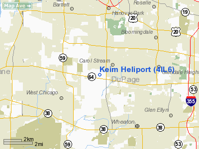
Location
& QuickFacts
|
FAA
Information Effective: |
2007-12-20 |
|
Airport
Identifier: |
4IL6 |
|
Airport
Status: |
Operational |
|
Longitude/Latitude: |
088-09-32.2560W/41-54-45.1020N
-88.158960/41.912528 (Estimated) |
|
Elevation: |
795 ft / 242.32 m (Estimated) |
|
Land: |
1 acres |
|
From
nearest city: |
3 nautical miles NE of West Chicago, IL |
|
Location: |
Du Page County, IL |
|
Magnetic Variation: |
00W (1985) |
Owner
& Manager
|
Ownership: |
Privately
owned |
|
Owner: |
Joe Keim Land Corp |
|
Address: |
301 East Longfellow Drive
Wheaton, IL 60187 |
|
Phone
number: |
708-260-0500 |
|
Manager: |
Joseph A. Keim |
|
Address: |
301 E. Longfellow Dr
Wheaton, IL 60187 |
|
Phone number: |
630-260-0500 |
Airport Operations and Facilities
|
Airport
Use: |
Private |
|
Wind
indicator: |
Yes |
|
Segmented Circle: |
No |
|
Control
Tower: |
No |
|
Sectional chart: |
Chicago |
|
Region: |
AGL - Great Lakes |
|
Boundary
ARTCC: |
ZAU - Chicago |
|
Tie-in
FSS: |
IKK - Kankakee |
|
FSS
Toll Free: |
1-800-WX-BRIEF |
|
Runway Information
Helipad H1
|
Dimension: |
32
x 32 ft / 9.8 x 9.8 m |
|
Surface: |
CONC, |
|
|
Runway H1 |
Runway |
|
Traffic
Pattern: |
Left |
Left |
|
Radio Navigation
Aids
|
ID |
Type |
Name |
Ch |
Freq |
Var |
Dist |
|
ME |
NDB |
Deana |
|
350.00 |
00E |
6.8
nm |
|
HK |
NDB |
Ermin |
|
332.00 |
01W |
18.6
nm |
|
MX |
NDB |
Kedzi |
|
248.00 |
01W |
23.4
nm |
|
DKB |
NDB |
Dekalb |
|
209.00 |
02W |
24.6
nm |
|
OIX |
NDB |
Ottawa |
|
266.00 |
01E |
45.5
nm |
|
RA |
NDB |
Paser |
|
206.00 |
00E |
47.7
nm |
|
DPA |
VOR/DME |
Dupage |
021X |
108.40 |
02E |
8.7
nm |
|
ORD |
VOR/DME |
Chicago
O'hare |
086X |
113.90 |
02E |
12.2
nm |
|
OBK |
VOR/DME |
Northbrook |
077X |
113.00 |
02W |
20.7
nm |
|
ENW |
VOR/DME |
Kenosha |
029X |
109.20 |
02W |
42.5
nm |
|
BUU |
VOR/DME |
Burbun |
092X |
114.50 |
01W |
47.1
nm |
|
JOT |
VORTAC |
Joliet |
070X |
112.30 |
02E |
23.1
nm |
|
CGT |
VORTAC |
Chicago
Heights |
089X |
114.20 |
02E |
35.8
nm |
|
EON |
VORTAC |
Peotone |
079X |
113.20 |
02E |
42.0
nm |
|
ORD |
VOT |
Chicago
O'hare Intl |
|
112.00 |
|
12.0
nm |
|
MDW |
VOT |
Chicago
Midway |
|
111.00 |
|
19.7
nm |
Remarks
- ALL
APCH/DEPOPS 190-210 DEGS & 110-130 DEGS; TAKEOFF/LDG AREA APPROPIATELY
MKD; NON-OBSTRUCTING WIND INDICATOR MAINTAINED.
Based
Aircraft
|
Aircraft
based on field: |
1 |
|
Multi
Engine Airplanes: |
1 |
Keim Heliport
Address:
Du Page County, IL
Tel:
708-260-0500
Images
and information placed above are from
http://www.airport-data.com/airport/4IL6/
We
thank them for the data!
| General
Info |
| Country |
United
States |
| State |
ILLINOIS
|
| FAA ID |
4IL6 |
| Latitude |
41-54-45.102N
|
| Longitude |
088-09-32.256W
|
| Elevation |
795 feet
|
| Near City |
WEST CHICAGO
|
We don't guarantee the information is fresh and accurate. The data may
be wrong or outdated.
For more up-to-date information please refer to other sources.
|
|


