 |
|
Coordinates: 41°04′17″N 087°50′47″W / 41.07139°N 87.84639°W / 41.07139; -87.84639
| Greater Kankakee Airport |
| IATA: IKK – ICAO: KIKK – FAA LID: IKK |
| Summary |
| Airport type |
Public |
| Owner/Operator |
Kankakee Valley Airport Authority |
| Serves |
Kankakee, Illinois |
| Elevation AMSL |
630 ft / 192 m |
| Website |
www.kvaa.com |
| Runways |
| Direction |
Length |
Surface |
| ft |
m |
| 4/22 |
5,979 |
1,822 |
Asphalt |
| 16/34 |
4,399 |
1,341 |
Asphalt |
| Statistics (2005) |
| Aircraft operations |
50,000 |
| Based aircraft |
135 |
| Source: Federal Aviation Administration |
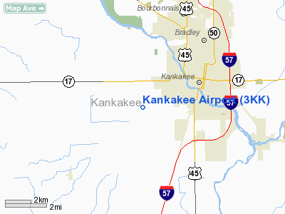
Greater Kankakee Airport (IATA: IKK, ICAO: KIKK, FAA LID: IKK) is a public airport located three miles (5 km) south of the central business district of Kankakee, in Kankakee County, Illinois, United States.
The airport was opened in 1962 and continues to operate as a general aviation facility serving the Kankakee area and South Chicago. It is 60 miles (97 km) south of Chicago and 75 miles (121 km) north of Champaign, Illinois. It is the largest Airport between the Chicago Midway Airport and the Champaign Airport. Greater Kankakee is a general aviation airport, consisting of mostly private aircraft with a mix of corporate and business aircraft usage.
The airport is owned and operated by the Kankakee Valley Airport Authority. The Authority has an appointed board of directors totaling six members. Members are appointed one each from the local communities of Kankakee, Bradley, and Bourbonnais and three members from the Kankakee County Board.
Facilities and airports
Greater Kankakee Airport covers an area of 950 acres (384 ha) which contains two asphalt paved runways: 4/22 measuring 5,979 x 100 ft (1,822 x 30 m) and 16/34 measuring 4,399 x 75 ft (1,341 x 23 m).
For the 12-month period ending December 31, 2005, the airport had 50,000 aircraft operations, an average of 136 per day: 92% general aviation, 6% military and 2% air taxi. There are 135 aircraft based at this airport: 73% single engine, 13% multi-engine, 11% ultralight, 1% jet and 1% helicopter.
The above content comes from Wikipedia and is published under free licenses – click here to read more.
Location
& QuickFacts
|
FAA
Information Effective: |
2007-12-20 |
|
Airport
Identifier: |
3KK |
|
Airport
Status: |
Operational |
|
Longitude/Latitude: |
087-55-00.1560W/41-06-00.1160N
-87.916710/41.100032 (Estimated) |
|
Elevation: |
625 ft / 190.50 m (Estimated) |
|
Land: |
280 acres |
|
From
nearest city: |
3 nautical miles SW of Kankakee, IL |
|
Location: |
Kankakee County, IL |
|
Magnetic Variation: |
01W (1985) |
Owner & Manager
|
Ownership: |
Privately owned |
|
Owner: |
Roger Koerner, Sr. |
|
Address: |
1520 S Rt 115
Kankakee, IL 60901 |
|
Phone number: |
815-932-4222 |
|
Manager: |
Roger Koerner, Sr. |
|
Address: |
1520 So. Rt. 115
Kankakee, IL 60901 |
|
Phone number: |
815-932-4222 |
Airport
Operations and Facilities
|
Airport
Use: |
Open
to public |
|
Wind
indicator: |
Yes |
|
Segmented Circle: |
No |
|
Control
Tower: |
No |
|
Lighting
Schedule: |
DUSK-DAWN
LIGHTS ON PHOTOCELL |
|
Landing
fee charge: |
No |
|
Sectional chart: |
Chicago |
|
Region: |
AGL - Great Lakes |
|
Traffic
Pattern Alt: |
800 ft |
|
Boundary
ARTCC: |
ZAU - Chicago |
|
Tie-in
FSS: |
IKK - Kankakee |
|
FSS
on Airport: |
No |
|
FSS
Toll Free: |
1-800-WX-BRIEF |
|
NOTAMs
Facility: |
IKK (NOTAM-d service avaliable) |
Airport Communications
|
CTAF: |
122.800 |
|
Unicom: |
122.800 |
Airport Services
|
Fuel
available: |
100LL |
|
Airframe
Repair: |
MAJOR |
|
Power
Plant Repair: |
MAJOR |
|
Bottled
Oxygen: |
NONE |
|
Bulk
Oxygen: |
NONE |
|
Runway Information
Runway 09/27
|
Dimension: |
2644
x 300 ft / 805.9 x 91.4 m |
|
Surface: |
TURF, Good Condition |
|
Edge
Lights: |
Non-standard lighting system
NSTD LIRL; VARIABLE INTST & SPACING & NON-FRANGIBLE MOUNTINGS. |
|
|
Runway 09 |
Runway 27 |
|
Longitude: |
087-55-00.1500W |
087-54-25.6200W |
|
Latitude: |
41-05-47.6100N |
41-05-47.6100N |
|
Elevation: |
624.00 ft |
619.00 ft |
|
Traffic
Pattern: |
Left |
Left |
|
Markings: |
None, |
None, |
|
Displaced
threshold: |
0.00 ft |
285.00 ft
RYS 27 & 36 DSPLCD THLDS MKD WITH WHITE ROCKS. |
|
Runway
End Identifier: |
No |
No |
|
Centerline
Lights: |
No |
No |
|
Touchdown
Lights: |
No |
No |
|
Obstruction: |
, 50:1 slope to clear |
15 ft road, 15.0 ft from runway, 1:1 slope
to clear |
|
Runway 18/36
|
Dimension: |
2564
x 200 ft / 781.5 x 61.0 m |
|
Surface: |
TURF, Good Condition |
|
|
Runway 18 |
Runway 36 |
|
Longitude: |
087-54-35.1500W |
087-54-35.1500W |
|
Latitude: |
41-05-53.1100N |
41-05-27.7800N |
|
Elevation: |
619.00 ft |
624.00 ft |
|
Traffic
Pattern: |
Left |
Left |
|
Markings: |
None, |
None, |
|
Displaced
threshold: |
0.00 ft |
900.00 ft |
|
Runway
End Identifier: |
No |
No |
|
Centerline
Lights: |
No |
No |
|
Touchdown
Lights: |
No |
No |
|
Obstruction: |
, 50:1 slope to clear |
54 ft trees, 47.0 ft from runway |
|
Radio Navigation
Aids
|
ID |
Type |
Name |
Ch |
Freq |
Var |
Dist |
|
RZL |
NDB |
Rensselaer |
|
362.00 |
02W |
34.5
nm |
|
HK |
NDB |
Ermin |
|
332.00 |
01W |
37.4
nm |
|
MX |
NDB |
Kedzi |
|
248.00 |
01W |
39.9
nm |
|
OIX |
NDB |
Ottawa |
|
266.00 |
01E |
45.2
nm |
|
IKK |
VOR/DME |
Kankakee |
053X |
111.60 |
00E |
3.4
nm |
|
RBS |
VOR/DME |
Roberts |
115X |
116.80 |
02E |
33.1
nm |
|
PNT |
VOR/DME |
Pontiac |
033X |
109.60 |
03E |
40.7
nm |
|
EON |
VORTAC |
Peotone |
079X |
113.20 |
02E |
11.7
nm |
|
CGT |
VORTAC |
Chicago
Heights |
089X |
114.20 |
02E |
29.2
nm |
|
JOT |
VORTAC |
Joliet |
070X |
112.30 |
02E |
32.4
nm |
|
MDW |
VOT |
Chicago
Midway |
|
111.00 |
|
41.9
nm |
Remarks
- ULTRALIGHT
ACTIVITY ON & INVOF ARPT.
- EXISTED
PRIOR TO 1959.
Based
Aircraft
|
Aircraft
based on field: |
25 |
|
Single
Engine Airplanes: |
22 |
|
Multi
Engine Airplanes: |
1 |
|
Ultralights: |
2 |
Operational Statistics
Time Period: 2004-01-02 - 2004-12-31
|
Aircraft
Operations: |
212/Week |
|
General
Aviation Local: |
81.8% |
|
General
Aviation Itinerant: |
18.2% |
Kankakee Airport
Address:
Kankakee County, IL
Tel:
815-932-4222
Images
and information placed above are from
http://www.airport-data.com/airport/3KK/
We
thank them for the data!
| General
Info |
| Country |
United
States |
| State |
ILLINOIS
|
| FAA ID |
3KK |
| Latitude |
41-06-00.116N
|
| Longitude |
087-55-00.156W
|
| Elevation |
625 feet
|
| Near City |
KANKAKEE
|
We don't guarantee the information is fresh and accurate. The data may
be wrong or outdated.
For more up-to-date information please refer to other sources.
|
|


