|
|
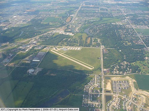
| Joliet Regional Airport |
| IATA: JOT â ICAO: KJOT â FAA LID: JOT |
| Summary |
| Airport type |
Public |
| Owner/Operator |
Joliet Park District |
| Serves |
Joliet, Illinois |
| Elevation AMSL |
582 ft / 177 m |
| Coordinates |
41°31â²04â³N 088°10â²32â³W / 41.51778°N 88.17556°W / 41.51778; -88.17556 |
| Website |
Official site |
| Runways |
| Direction |
Length |
Surface |
| ft |
m |
| 12/30 |
2,937 |
895 |
Asphalt |
| 4/22 |
2,746 |
837 |
Turf |
| Statistics (2010) |
| Aircraft operations |
25,000 |
| Based aircraft |
114 |
| Sources: airport web site and FAA |
| Joliet Park District Airport Hangar Building |
| U.S. National Register of Historic Places |
|
|
| Location: |
Joliet, Illinois |
| Coordinates: |
41°31â²04â³N 88°10â²32â³W / 41.51778°N 88.17556°W / 41.51778; -88.17556Coordinates: 41°31â²04â³N 88°10â²32â³W / 41.51778°N 88.17556°W / 41.51778; -88.17556 |
| Built/Founded: |
1930 |
| Architectural style(s): |
Art Deco with Streamline Moderne |
| Governing body: |
Local |
| Added to NRHP: |
1980 |
| NRHP Reference#: |
80001419 |
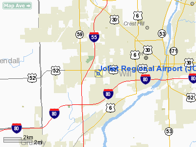
Joliet Regional Airport (IATA: JOT, ICAO: KJOT, FAA LID: JOT) is a public use airport located four nautical miles (7 km) west of the central business district of Joliet, a city in Will County, Illinois, United States. It is owned by the Joliet Park District.
The airport is also 37 miles (60 kilometers) southwest of Chicago. It opened in April of 1930. History
Joliet's first airport, Originally known as Joliet Municipal Airport, was proposed by Illinois Senator Richard Barr in the mid 1920s. It was operated by the Joliet Park District, the first airport in the country to be operated by such an authority. The land was purchased in September 1928 and the airport was built with assistance from the United States Department of Commerce. The airport was dedicated in September 1930, with an aerobatics show and bomb-dropping. The Park District relocated their main office to the airport. Most operations were transferred to a new airfield in 1940. A transmitter is still functional at the old airport and the hangar was added to the National Register of Historic Places in 1980.
Facilities and aircraft
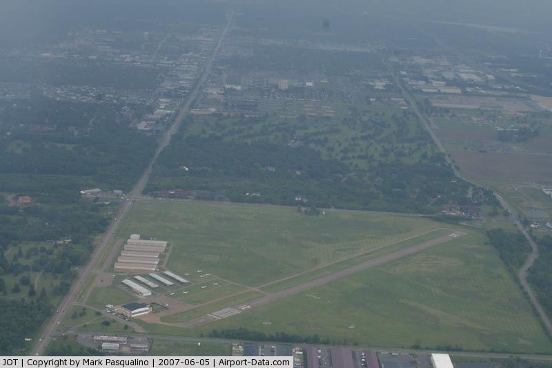
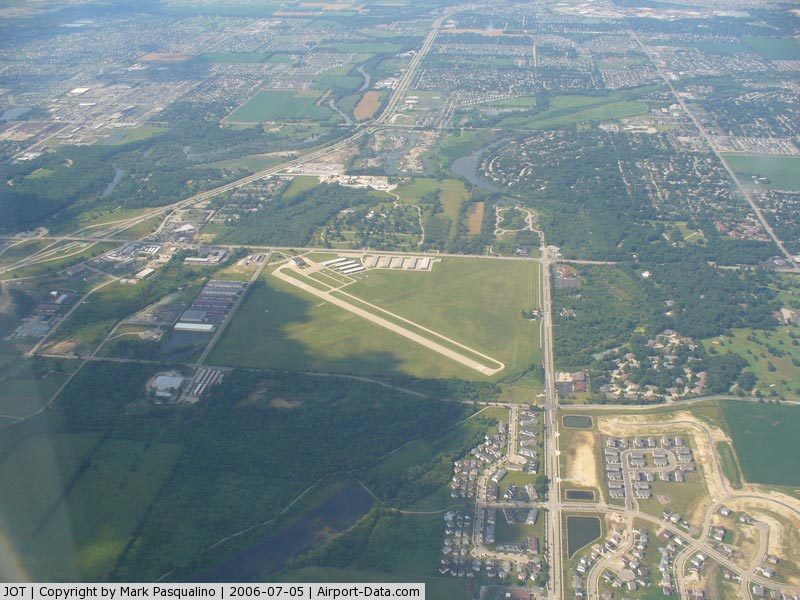
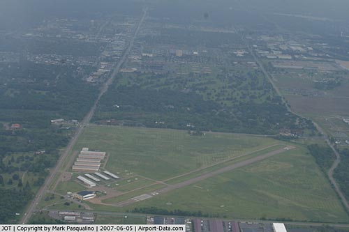
Joliet Regional Airport covers an area of 178 acres (72 ha) at an elevation of 581 feet (177 m) above mean sea level. It has two runways: 12/30 is 2,937 by 100 feet (895 x 30 m) with an asphalt pavement and 4/22 is 2,746 by 150 feet (837 x 45m) with a turf surface.
For the 12-month period ending December 31, 2006, the airport had 25,000 aircraft operations, an average of 68 per day: 89% general aviation, 8% air taxi, and 3% military. At that time there were 114 aircraft based at this airport: 91% single-engine, 6% multi-engine and 3% helicopter.
The above content comes from Wikipedia and is published under free licenses – click here to read more.
|
 |
(Click on the photo to enlarge) |
|
 |
(Click on the photo to enlarge) |
Location
& QuickFacts
|
FAA
Information Effective: |
2007-12-20 |
|
Airport
Identifier: |
JOT |
|
Airport
Status: |
Operational |
|
Longitude/Latitude: |
088-10-31.9000W/41-31-04.1000N
-88.175528/41.517806 (Estimated) |
|
Elevation: |
581 ft / 177.09 m (Surveyed) |
|
Land: |
178 acres |
|
From
nearest city: |
4 nautical miles W of Joliet, IL |
|
Location: |
Will County, IL |
|
Magnetic Variation: |
02E (1965) |
Owner & Manager
|
Ownership: |
Publicly owned |
|
Owner: |
Joliet Park District |
|
Address: |
4000 W Jefferson
Joliet, IL 60435 |
|
Phone number: |
815-741-7275 |
|
Manager: |
Bill Reuter |
|
Address: |
4000 W Jefferson
Joliet, IL 60435 |
|
Phone number: |
815-741-7267 |
Airport
Operations and Facilities
|
Airport
Use: |
Open
to public |
|
Wind
indicator: |
Yes |
|
Segmented Circle: |
No |
|
Control
Tower: |
No |
|
Lighting
Schedule: |
DUSK-DAWN
MIRL RY 12/30 PRESET ON LOW INTST - TO ACTVT HIGHER INTST
- CTAF. |
|
Beacon
Color: |
Clear-Green (lighted land airport) |
|
Landing
fee charge: |
No |
|
Sectional chart: |
Chicago |
|
Region: |
AGL - Great Lakes |
|
Boundary
ARTCC: |
ZAU - Chicago |
|
Tie-in
FSS: |
IKK - Kankakee |
|
FSS
on Airport: |
No |
|
FSS
Toll Free: |
1-800-WX-BRIEF |
|
NOTAMs
Facility: |
JOT (NOTAM-d service avaliable) |
|
Federal Agreements: |
N |
Airport Communications
|
CTAF: |
122.700 |
|
Unicom: |
122.700
|
Airport
Services
|
Fuel
available: |
100LLA
MOGAS |
|
Airframe
Repair: |
MAJOR |
|
Power
Plant Repair: |
MAJOR |
|
Bottled
Oxygen: |
NONE |
|
Bulk
Oxygen: |
LOW |
|
Runway Information
Runway 04/22
|
Dimension: |
3228
x 140 ft / 983.9 x 42.7 m |
|
Surface: |
TURF, Fair Condition |
|
|
Runway 04 |
Runway 22 |
|
Longitude: |
088-10-47.1566W |
088-10-17.5697W |
|
Latitude: |
41-30-53.4810N |
41-31-16.3418N |
|
Elevation: |
574.00 ft |
581.00 ft |
|
Alignment: |
44 |
127 |
|
Traffic
Pattern: |
Left |
Left |
|
Runway
End Identifier: |
No |
No |
|
Centerline
Lights: |
No |
No |
|
Touchdown
Lights: |
No |
No |
|
Obstruction: |
21 ft pole, 307.0 ft from runway, 115 ft right
of centerline, 15:1 slope to clear |
35 ft tree, 700.0 ft from runway, 150 ft right
of centerline, 20:1 slope to clear |
|
Runway 12/30
|
Dimension: |
2937
x 100 ft / 895.2 x 30.5 m |
|
Surface: |
ASPH, Good Condition |
|
Weight
Limit: |
Single wheel: 8000 lbs. |
|
Edge
Lights: |
Medium |
|
|
Runway 12 |
Runway 30 |
|
Longitude: |
088-10-46.8485W |
088-10-15.8639W |
|
Latitude: |
41-31-11.7916N |
41-30-54.4752N |
|
Elevation: |
580.00 ft |
577.00 ft |
|
Alignment: |
127 |
127 |
|
Traffic
Pattern: |
Left |
Left |
|
Markings: |
Numbers only, Poor Condition
PAINT MARKINGS ARE FADED TO THE POINT THEY ARE HARD TO READ
FROM THE AIR. |
Numbers only, Poor Condition |
|
Crossing
Height: |
37.00 ft |
0.00 ft |
|
Displaced
threshold: |
250.00 ft |
80.00 ft |
|
VASI: |
4-light PAPI on right side |
|
|
Visual
Glide Angle: |
3.00° |
0.00° |
|
Runway
End Identifier: |
Yes |
No |
|
Centerline
Lights: |
No |
No |
|
Touchdown
Lights: |
No |
No |
|
Obstruction: |
20 ft other, 401.0 ft from runway, 45 ft left
of centerline, 10:1 slope to clear
APCH RATIO 20:1 TO DSPLCD THLD. +48 FT TERMINAL BLDG 194 FT
DSTC 257 FT LEFT.
+15 FT ROAD AT 100 FT 0B. |
41 ft tree, 675.0 ft from runway, 24 ft right
of centerline, 11:1 slope to clear
APCH RATIO 18:1 TO DSPLCD THLD. |
|
Radio Navigation
Aids
|
ID |
Type |
Name |
Ch |
Freq |
Var |
Dist |
|
HK |
NDB |
Ermin |
|
332.00 |
01W |
19.5
nm |
|
MX |
NDB |
Kedzi |
|
248.00 |
01W |
25.6
nm |
|
ME |
NDB |
Deana |
|
350.00 |
00E |
27.9
nm |
|
OIX |
NDB |
Ottawa |
|
266.00 |
01E |
32.0
nm |
|
DKB |
NDB |
Dekalb |
|
209.00 |
02W |
34.6
nm |
|
VYS |
NDB |
Valley |
|
230.00 |
00W |
44.9
nm |
|
DPA |
VOR/DME |
Dupage |
021X |
108.40 |
02E |
23.7
nm |
|
IKK |
VOR/DME |
Kankakee |
053X |
111.60 |
00E |
30.4
nm |
|
ORD |
VOR/DME |
Chicago
O'hare |
086X |
113.90 |
02E |
30.7
nm |
|
OBK |
VOR/DME |
Northbrook |
077X |
113.00 |
02W |
43.5
nm |
|
PNT |
VOR/DME |
Pontiac |
033X |
109.60 |
03E |
48.9
nm |
|
JOT |
VORTAC |
Joliet |
070X |
112.30 |
02E |
6.7
nm |
|
EON |
VORTAC |
Peotone |
079X |
113.20 |
02E |
22.9
nm |
|
CGT |
VORTAC |
Chicago
Heights |
089X |
114.20 |
02E |
27.2
nm |
|
MDW |
VOT |
Chicago
Midway |
|
111.00 |
|
24.9
nm |
|
ORD |
VOT |
Chicago
O'hare Intl |
|
112.00 |
|
30.4
nm |
Remarks
Based
Aircraft
|
Aircraft
based on field: |
132 |
|
Single
Engine Airplanes: |
128 |
|
Multi
Engine Airplanes: |
3 |
|
Helicopters: |
1 |
Operational Statistics
Time Period: 2006-01-01 - 2006-12-31
|
Aircraft
Operations: |
69/Day |
|
Air
Taxi: |
8.0% |
|
General
Aviation Local: |
44.0% |
|
General
Aviation Itinerant: |
45.2% |
|
Military: |
2.8% |
Joliet Regional Airport
Address:
Will County, IL
Tel:
815-741-7275,
815-741-7267
Images
and information placed above are from
http://www.airport-data.com/airport/JOT/
We
thank them for the data!
| General
Info |
| Country |
United
States |
| State |
ILLINOIS
|
| FAA ID |
JOT |
| Latitude |
41-31-04.100N
|
| Longitude |
088-10-31.900W
|
| Elevation |
581 feet
|
| Near City |
JOLIET
|
We don't guarantee the information is fresh and accurate. The data may
be wrong or outdated.
For more up-to-date information please refer to other sources.
|
|