 |
|
|
|
|
|
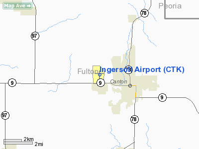
Location
& QuickFacts
|
FAA
Information Effective: |
2007-12-20 |
|
Airport
Identifier: |
CTK |
|
Airport
Status: |
Operational |
|
Longitude/Latitude: |
090-04-29.4240W/40-34-08.7400N
-90.074840/40.569094 (Estimated) |
|
Elevation: |
684 ft / 208.48 m (Surveyed) |
|
Land: |
232 acres |
|
From
nearest city: |
2 nautical miles NW of Canton, IL |
|
Location: |
Fulton County, IL |
|
Magnetic Variation: |
02E (1980) |
Owner
& Manager
|
Ownership: |
Publicly
owned |
|
Owner: |
Canton Park District |
|
Address: |
250 S Ave D
Canton, IL 61520 |
|
Phone
number: |
309-647-1345 |
|
Manager: |
John Johnson |
|
Address: |
250 S Ave D
Canton, IL 61520 |
|
Phone number: |
309-647-1345 |
Airport Operations and Facilities
|
Airport
Use: |
Open
to public |
|
Wind
indicator: |
Yes |
|
Segmented Circle: |
Yes |
|
Control
Tower: |
No |
|
Lighting
Schedule: |
DUSK-DAWN
ACTVT MIRL RYS 09/27 & 18/36 & REIL RY 36 &
TWY LGTS - CTAF. |
|
Beacon
Color: |
Clear-Green (lighted land airport) |
|
Landing
fee charge: |
No |
|
Sectional chart: |
Chicago |
|
Region: |
AGL - Great Lakes |
|
Traffic
Pattern Alt: |
800 ft |
|
Boundary
ARTCC: |
ZAU - Chicago |
|
Tie-in
FSS: |
IKK - Kankakee |
|
FSS
on Airport: |
No |
|
FSS
Toll Free: |
1-800-WX-BRIEF |
|
NOTAMs
Facility: |
IKK (NOTAM-d service avaliable) |
|
Federal Agreements: |
NGY |
Airport Communications
|
CTAF: |
122.800 |
|
Unicom: |
122.800
|
Airport
Services
|
Fuel
available: |
100LLMOGAS |
|
Airframe
Repair: |
MAJOR |
|
Power
Plant Repair: |
MAJOR |
|
Bottled
Oxygen: |
NONE |
|
Bulk
Oxygen: |
NONE |
|
Runway Information
Runway 09/27
|
Dimension: |
3295
x 60 ft / 1004.3 x 18.3 m |
|
Surface: |
ASPH, Good Condition |
|
Weight
Limit: |
Single wheel: 11000 lbs. |
|
Edge
Lights: |
Medium |
|
|
Runway
09 |
Runway
27 |
|
Longitude: |
090-04-54.2710W |
090-04-11.5790W |
|
Latitude: |
40-34-14.3510N |
40-34-14.5840N |
|
Elevation: |
684.00 ft |
682.00 ft |
|
Alignment: |
89 |
127 |
|
Traffic
Pattern: |
Left |
Left |
|
Markings: |
Basic, Good Condition |
Basic, Good Condition |
|
Runway
End Identifier: |
No |
No |
|
Touchdown
Lights: |
No |
No |
|
Obstruction: |
19 ft pole, 999.0 ft from runway, 8 ft left
of centerline, 42:1 slope to clear |
41 ft tree, 969.0 ft from runway, 38 ft right
of centerline, 18:1 slope to clear |
|
Runway 18/36
|
Dimension: |
3899
x 75 ft / 1188.4 x 22.9 m |
|
Surface: |
ASPH, Fair Condition |
|
Weight
Limit: |
Single wheel: 10000 lbs. |
|
Edge
Lights: |
Medium |
|
|
Runway
18 |
Runway
36 |
|
Longitude: |
090-04-25.9390W |
090-04-26.9830W |
|
Latitude: |
40-34-23.0810N |
40-33-44.5570N |
|
Elevation: |
682.00 ft |
671.00 ft |
|
Alignment: |
127 |
1 |
|
Traffic
Pattern: |
Left |
Left |
|
Markings: |
Non-precision instrument, Good Condition |
Non-precision instrument, Good Condition |
|
Runway
End Identifier: |
No |
Yes |
|
Centerline
Lights: |
No |
No |
|
Touchdown
Lights: |
No |
No |
|
Obstruction: |
56 ft trees, 1748.0 ft from runway, 301 ft
right of centerline, 27:1 slope to clear |
48 ft trees, 1228.0 ft from runway, 328 ft
left of centerline, 21:1 slope to clear |
|
Radio Navigation
Aids
|
ID |
Type |
Name |
Ch |
Freq |
Var |
Dist |
|
CTK |
NDB |
Canton |
|
236.00 |
02E |
0.2
nm |
|
PI |
NDB |
Tungg |
|
356.00 |
01E |
22.1
nm |
|
JZY |
NDB |
Macomb |
|
251.00 |
01E |
22.4
nm |
|
EZI |
NDB |
Kewanee |
|
245.00 |
01E |
38.4
nm |
|
AAA |
NDB |
Abraham |
|
329.00 |
00E |
41.8
nm |
|
LQ |
NDB |
Licol |
|
375.00 |
01W |
45.0
nm |
|
SP |
NDB |
Huskk |
|
382.00 |
01W |
50.0
nm |
|
GBG |
VOR/DME |
Galesburg |
035X |
109.80 |
03E |
27.5
nm |
|
IJX |
VOR/DME |
Jacksonville |
023X |
108.60 |
02E |
48.2
nm |
|
PIA |
VORTAC |
Peoria |
099X |
115.20 |
04E |
14.5
nm |
|
BRL |
VORTAC |
Burlington |
051X |
111.40 |
05E |
39.9
nm |
|
BDF |
VORTAC |
Bradford |
094X |
114.70 |
00E |
41.8
nm |
|
CAP |
VORTAC |
Capital |
074X |
112.70 |
04E |
45.6
nm |
|
SPI |
VORTAC |
Spinner |
74X |
112.70 |
01W |
47.5
nm |
Based
Aircraft
|
Aircraft
based on field: |
51 |
|
Single
Engine Airplanes: |
47 |
|
Gliders: |
1 |
|
Ultralights: |
3 |
Operational Statistics
Time Period: 2005-01-01 - 2005-12-31
|
Aircraft
Operations: |
53/Day |
|
General
Aviation Local: |
89.5% |
|
General
Aviation Itinerant: |
10.5% |
Ingersoll
Fulton Airport
Address:
Fulton County, IL
Tel:
309-647-1345
Images
and information placed above are from
http://www.airport-data.com/airport/CTK/
We
thank them for the data!
| General
Info |
| Country |
United
States |
| State |
ILLINOIS
|
| FAA ID |
CTK |
| Time |
UTC-6(-5DT)
|
| Latitude |
40.569094
40° 34' 08.74" N |
| Longitude |
-90.074839
090° 04' 29.42" W |
| Elevation |
684 feet
208 meters |
| Type |
Civil
|
| Magnetic
Variation |
000° W
(01/06) |
| Beacon |
Yes |
| Operating
Agency |
U.S.CIVIL
AIRPORT WHEREIN PERMIT COVERS USE BY TRANSIT MILITARY AIRCRAFT |
| Near City |
Canton
|
| Operating
Hours |
SEE REMARKS
FOR OPERATING HOURS OR COMMUNICATIONS FOR POSSIBLE HOURS |
| Daylight
Saving Time |
Second
Sunday in March at 0200 to first Sunday in November at 0200 local
time (Exception Arizona and that portion of Indiana in the Eastern
Time Zone) |
We don't guarantee the information is fresh and accurate. The data may
be wrong or outdated.
For more up-to-date information please refer to other sources.
|
|


