 |
|
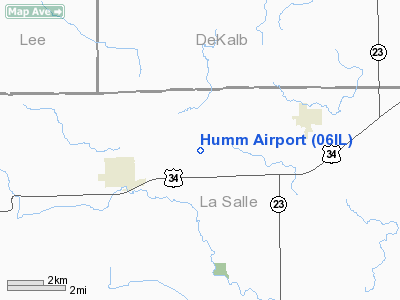
Location
& QuickFacts
|
FAA
Information Effective: |
2007-12-20 |
|
Airport
Identifier: |
06IL |
|
Airport
Status: |
Operational |
|
Longitude/Latitude: |
088-52-11.8000W/41-35-58.3000N
-88.869944/41.599528 (Estimated) |
|
Elevation: |
708 ft / 215.80 m (Estimated) |
|
Land: |
0 acres |
|
From
nearest city: |
3 nautical miles E of Earlville, IL |
|
Location: |
Adams County, IL |
|
Magnetic Variation: |
01W (1995) |
Owner
& Manager
|
Ownership: |
Privately
owned |
|
Owner: |
Stanley Humm |
|
Address: |
411 North Tyler Road
St Charles, IL 60174 |
|
Phone
number: |
630-584-9344 |
|
Manager: |
Stanley Humm |
|
Address: |
411 North Tyler Road
St Charles, IL 60174 |
|
Phone number: |
630-584-9344 |
Airport Operations and Facilities
|
Airport
Use: |
Private |
|
Wind
indicator: |
Yes |
|
Segmented Circle: |
No |
|
Control
Tower: |
No |
|
Sectional chart: |
Chicago |
|
Region: |
AGL - Great Lakes |
|
Boundary
ARTCC: |
ZAU - Chicago |
|
Tie-in
FSS: |
IKK - Kankakee |
|
FSS
Toll Free: |
1-800-WX-BRIEF |
|
Runway Information
Runway 09/27
|
Dimension: |
2580
x 70 ft / 786.4 x 21.3 m |
|
Surface: |
TURF, |
|
|
Runway 09 |
Runway 27 |
|
Traffic
Pattern: |
Left |
Left |
|
Obstruction: |
20 ft pline, 100.0 ft from runway |
30 ft pline, 0.0 ft from runway |
|
Radio Navigation
Aids
|
ID |
Type |
Name |
Ch |
Freq |
Var |
Dist |
|
OIX |
NDB |
Ottawa |
|
266.00 |
01E |
14.3
nm |
|
VYS |
NDB |
Valley |
|
230.00 |
00W |
19.3
nm |
|
DKB |
NDB |
Dekalb |
|
209.00 |
02W |
21.4
nm |
|
BOZ |
NDB |
Whiteside |
|
254.00 |
01E |
41.7
nm |
|
ME |
NDB |
Deana |
|
350.00 |
00E |
43.8
nm |
|
HK |
NDB |
Ermin |
|
332.00 |
01W |
47.0
nm |
|
DPA |
VOR/DME |
Dupage |
021X |
108.40 |
02E |
29.1
nm |
|
PLL |
VOR/DME |
Polo |
049X |
111.20 |
03E |
36.7
nm |
|
RFD |
VOR/DME |
Rockford |
045X |
110.80 |
01E |
40.4
nm |
|
PNT |
VOR/DME |
Pontiac |
033X |
109.60 |
03E |
47.2
nm |
|
ORD |
VOR/DME |
Chicago
O'hare |
086X |
113.90 |
02E |
49.1
nm |
|
JOT |
VORTAC |
Joliet |
070X |
112.30 |
02E |
25.0
nm |
|
BDF |
VORTAC |
Bradford |
094X |
114.70 |
00E |
41.8
nm |
|
ORD |
VOT |
Chicago
O'hare Intl |
|
112.00 |
|
48.9
nm |
Remarks
- PRVDD
CLEAR 20:1 APCH; AREA 125 FT EITHER SIDE OF RY CNTRLN AND 200 FT OF
RY ENDS ARE CLEAR; AREA 60 FT EITHER SIDE OF THE RY CNTRLN AND 240 FT
OFF RY ENDS ARE CLEAR.
Humm Airport
Address:
Adams County, IL
Tel:
630-584-9344
Images
and information placed above are from
http://www.airport-data.com/airport/06IL/
We
thank them for the data!
| General
Info |
| Country |
United
States |
| State |
ILLINOIS
|
| FAA ID |
06IL |
| Latitude |
41-35-58.300N
|
| Longitude |
088-52-11.800W
|
| Elevation |
708 feet
|
| Near City |
EARLVILLE
|
We don't guarantee the information is fresh and accurate. The data may
be wrong or outdated.
For more up-to-date information please refer to other sources.
|
|


