 |
|
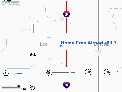
Location
& QuickFacts
|
FAA
Information Effective: |
2007-12-20 |
|
Airport
Identifier: |
3IL7 |
|
Airport
Status: |
Operational |
|
Longitude/Latitude: |
089-01-18.3320W/41-48-12.1050N
-89.021759/41.803363 (Estimated) |
|
Elevation: |
819 ft / 249.63 m (Estimated) |
|
Land: |
5 acres |
|
From
nearest city: |
3 nautical miles N of Steward, IL |
|
Location: |
Lee County, IL |
|
Magnetic Variation: |
00E (1990) |
Owner
& Manager
|
Ownership: |
Privately
owned |
|
Owner: |
Curt Rebold |
|
Address: |
3195 Herman Rd. Po Box 62
Steward, IL 60553 |
|
Phone
number: |
815-824-2238 |
|
Manager: |
Curt Rebold |
|
Address: |
3195 Herman Rd. Po Box 62
Steward, IL 60553 |
|
Phone number: |
815-824-2238 |
Airport Operations and Facilities
|
Airport
Use: |
Private |
|
Wind
indicator: |
Yes |
|
Segmented Circle: |
No |
|
Control
Tower: |
No |
|
Sectional chart: |
Chicago |
|
Region: |
AGL - Great Lakes |
|
Boundary
ARTCC: |
ZAU - Chicago |
|
Tie-in
FSS: |
IKK - Kankakee |
|
FSS
on Airport: |
No |
|
FSS
Toll Free: |
1-800-WX-BRIEF |
|
Runway Information
Runway 09/27
|
Dimension: |
800
x 60 ft / 243.8 x 18.3 m |
|
Surface: |
TURF, |
|
|
Runway 09 |
Runway 27 |
|
Traffic
Pattern: |
Left |
Left |
|
Displaced
threshold: |
0.00 ft |
370.00 ft |
|
Obstruction: |
40 ft pole, 2000.0 ft from runway |
20 ft pole, 30.0 ft from runway |
|
Radio Navigation
Aids
|
ID |
Type |
Name |
Ch |
Freq |
Var |
Dist |
|
DKB |
NDB |
Dekalb |
|
209.00 |
02W |
16.1
nm |
|
OIX |
NDB |
Ottawa |
|
266.00 |
01E |
27.5
nm |
|
VYS |
NDB |
Valley |
|
230.00 |
00W |
27.6
nm |
|
BOZ |
NDB |
Whiteside |
|
254.00 |
01E |
34.7
nm |
|
FEP |
NDB |
Freeport |
|
335.00 |
00E |
36.6
nm |
|
ME |
NDB |
Deana |
|
350.00 |
00E |
45.6
nm |
|
JVL |
NDB |
Janesville |
|
375.00 |
03E |
48.8
nm |
|
PLL |
VOR/DME |
Polo |
049X |
111.20 |
03E |
24.5
nm |
|
RFD |
VOR/DME |
Rockford |
045X |
110.80 |
01E |
26.6
nm |
|
DPA |
VOR/DME |
Dupage |
021X |
108.40 |
02E |
30.5
nm |
|
JVL |
VOR/DME |
Janesville |
090X |
114.30 |
03E |
45.5
nm |
|
JOT |
VORTAC |
Joliet |
070X |
112.30 |
02E |
35.2
nm |
|
BDF |
VORTAC |
Bradford |
094X |
114.70 |
00E |
46.3
nm |
Remarks
- PRVDD
OBSTRUCTIONS IN RY APCH SLOPE REMOVED/LOWERED TO PRVD MINIMUM 15:1 APCH
CLNC OVER ALL OBSTRUCTIONS.
Based
Aircraft
|
Aircraft
based on field: |
1 |
|
Single
Engine Airplanes: |
1 |
Home Free Airport
Address:
Lee County, IL
Tel:
815-824-2238
Images
and information placed above are from
http://www.airport-data.com/airport/3IL7/
We
thank them for the data!
| General
Info |
| Country |
United
States |
| State |
ILLINOIS
|
| FAA ID |
3IL7 |
| Latitude |
41-48-12.105N
|
| Longitude |
089-01-18.332W
|
| Elevation |
819 feet
|
| Near City |
STEWARD
|
We don't guarantee the information is fresh and accurate. The data may
be wrong or outdated.
For more up-to-date information please refer to other sources.
|
|


