 |
|
|
|
|
|
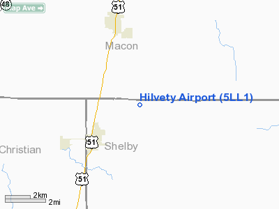
Location
& QuickFacts
|
FAA
Information Effective: |
2007-12-20 |
|
Airport
Identifier: |
5LL1 |
|
Airport
Status: |
Operational |
|
Longitude/Latitude: |
088-58-30.2790W/39-39-00.1370N
-88.975077/39.650038 (Estimated) |
|
Elevation: |
674 ft / 205.44 m (Surveyed) |
|
Land: |
160 acres |
|
From
nearest city: |
3 nautical miles NE of Moweaqua, IL |
|
Location: |
Shelby County, IL |
|
Magnetic Variation: |
01E (1985) |
Owner & Manager
|
Ownership: |
Privately owned |
|
Owner: |
Mark Hilvety |
|
Address: |
Rr 2 Box 53
Macon, IL 62544 |
|
Phone number: |
217-768-3197 |
|
Manager: |
Mark Hilvety |
|
Address: |
Rr 2 Box 53
Macon, IL 62544 |
|
Phone number: |
217-768-3197 |
Airport Operations and Facilities
|
Airport Use: |
Private |
|
Wind indicator: |
Yes |
|
Segmented Circle: |
No |
|
Control Tower: |
No |
|
Landing fee charge: |
No |
|
Sectional chart: |
St Louis |
|
Region: |
AGL - Great Lakes |
|
Boundary ARTCC: |
ZKC - Kansas City |
|
Responsible ARTCC: |
ZAU - Chicago |
|
Tie-in FSS: |
STL - Saint Louis |
|
FSS on Airport: |
No |
|
FSS Toll Free: |
1-800-WX-BRIEF |
Airport
Communications
Airport
Services
|
Airframe
Repair: |
NONE |
|
Power
Plant Repair: |
NONE |
|
Runway Information
Runway 09/27
|
Dimension: |
1780
x 100 ft / 542.5 x 30.5 m |
|
Surface: |
TURF, Good Condition |
|
|
Runway 09 |
Runway 27 |
|
Traffic
Pattern: |
Left |
Left |
|
Obstruction: |
26 ft pole, 853.0 ft from runway, 109 ft right
of centerline, 32:1 slope to clear |
, 50:1 slope to clear |
|
Runway 17/35
|
Dimension: |
2102
x 100 ft / 640.7 x 30.5 m |
|
Surface: |
TURF, Good Condition |
|
|
Runway 17 |
Runway 35 |
|
Traffic
Pattern: |
Left |
Left |
|
Markings: |
None, |
None, |
|
Displaced
threshold: |
500.00 ft
DSPLCD THR MKD WITH WHITE GRAVEL IN SHAPE OF 'L' ON RY EDGES. |
0.00 ft |
|
Runway
End Identifier: |
No |
No |
|
Centerline
Lights: |
No |
No |
|
Touchdown
Lights: |
No |
No |
|
Obstruction: |
30 ft tree, 50 ft right of centerline
APCH RATIO 16:1 TO DSPLCD THR. |
, 50:1 slope to clear |
|
Radio Navigation
Aids
|
ID |
Type |
Name |
Ch |
Freq |
Var |
Dist |
|
SYZ |
NDB |
Shelbyville |
|
365.00 |
01E |
15.8
nm |
|
TAZ |
NDB |
Taylorville |
|
395.00 |
00E |
17.5
nm |
|
LQ |
NDB |
Licol |
|
375.00 |
01W |
33.0
nm |
|
AAA |
NDB |
Abraham |
|
329.00 |
00E |
34.9
nm |
|
SP |
NDB |
Huskk |
|
382.00 |
01W |
37.0
nm |
|
MT |
NDB |
Zebre |
|
347.00 |
00E |
39.2
nm |
|
LTD |
NDB |
Litchfield |
|
371.00 |
01E |
43.7
nm |
|
CZB |
NDB |
Casey |
|
359.00 |
00E |
49.7
nm |
|
MTO |
VOR/DME |
Mattoon |
031X |
109.40 |
03E |
33.6
nm |
|
BMI |
VOR/DME |
Bloomington |
019X |
108.20 |
03E |
50.0
nm |
|
DEC |
VORTAC |
Decatur |
119X |
117.20 |
03E |
7.6
nm |
|
CAP |
VORTAC |
Capital |
074X |
112.70 |
04E |
33.4
nm |
|
SPI |
VORTAC |
Spinner |
74X |
112.70 |
01W |
34.4
nm |
|
VLA |
VORTAC |
Vandalia |
090X |
114.30 |
04E |
34.6
nm |
|
CMI |
VORTAC |
Champaign |
037X |
110.00 |
03E |
39.7
nm |
|
BIB |
VORTAC |
Bible
Grove |
027X |
109.00 |
03E |
49.5
nm |
Remarks
- BRUSH
INSIDE TRANSITION AREA AT SOUTH END RY 17/35.
- NG
HEL TRNG NGTS & RANDOM DAYS; CONTACT DEC TWR ON 118.9 FOR GUARD
ACTIVITIES.
- EXISTED
PRIOR TO 1959.
Based
Aircraft
|
Aircraft
based on field: |
8 |
|
Single
Engine Airplanes: |
2 |
|
Ultralights: |
6 |
Operational Statistics
Time Period: 1990-06-26 - 1991-06-25
|
Aircraft
Operations: |
97/Week |
|
General
Aviation Local: |
80.0% |
|
General
Aviation Itinerant: |
20.0% |
Hilvety Airport
Address:
Shelby County, IL
Tel:
217-768-3197
Images
and information placed above are from
http://www.airport-data.com/airport/5LL1/
We
thank them for the data!
| General
Info |
| Country |
United
States |
| State |
ILLINOIS
|
| FAA ID |
5LL1 |
| Latitude |
39-39-00.137N
|
| Longitude |
088-58-30.279W
|
| Elevation |
674 feet
|
| Near City |
MOWEAQUA
|
We don't guarantee the information is fresh and accurate. The data may
be wrong or outdated.
For more up-to-date information please refer to other sources.
|
|


