 |
|
Harrisburg-Raleigh Airport |
|
|
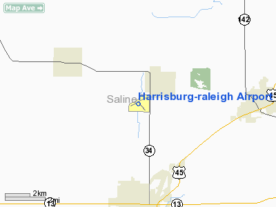
Location
& QuickFacts
|
FAA
Information Effective: |
2007-12-20 |
|
Airport
Identifier: |
HSB |
|
Airport
Status: |
Operational |
|
Longitude/Latitude: |
088-33-00.9347W/37-48-40.5220N
-88.550260/37.811256 (Estimated) |
|
Elevation: |
398 ft / 121.31 m (Surveyed) |
|
Land: |
398 acres |
|
From
nearest city: |
4 nautical miles N of Harrisburg, IL |
|
Location: |
Saline County, IL |
|
Magnetic Variation: |
00E (1990) |
Owner & Manager
|
Ownership: |
Publicly owned |
|
Owner: |
Harrisburg Raleigh Airport |
|
Address: |
Box 33
Harrisburg, IL 62946 |
|
Phone number: |
618-253-7806 |
|
Manager: |
Dale Shelton |
|
Address: |
Box 33
Harrisburg, IL 62946 |
|
Phone number: |
618-253-7806 |
Airport
Operations and Facilities
|
Airport
Use: |
Open
to public |
|
Wind
indicator: |
Yes |
|
Segmented Circle: |
Yes |
|
Control
Tower: |
No |
|
Lighting
Schedule: |
DUSK-DAWN
MIRL RY 06/24 PRESET ON LOW INTST; TO INCR INTST & ACTVT
MIRL RY 14/32; VASI RY 24; REIL RY 24 - CTAF. |
|
Beacon
Color: |
Clear-Green (lighted land airport) |
|
Landing
fee charge: |
No |
|
Sectional chart: |
St Louis |
|
Region: |
AGL - Great Lakes |
|
Traffic
Pattern Alt: |
800 ft |
|
Boundary
ARTCC: |
ZKC - Kansas City |
|
Tie-in
FSS: |
STL - Saint Louis |
|
FSS
on Airport: |
No |
|
FSS
Toll Free: |
1-800-WX-BRIEF |
|
NOTAMs
Facility: |
HSB (NOTAM-d service avaliable) |
|
Federal Agreements: |
NGY |
Airport Communications
|
CTAF: |
122.800 |
|
Unicom: |
122.800
|
Airport
Services
|
Fuel
available: |
100LLA |
|
Airframe
Repair: |
MINOR |
|
Power
Plant Repair: |
MINOR |
|
Runway Information
Runway 06/24
|
Dimension: |
5013 x 75 ft / 1528.0 x 22.9 m
HAS A 900 FT STWY NW END. |
|
Surface: |
ASPH, Good Condition |
|
Weight
Limit: |
Single wheel: 12000 lbs. |
|
Edge
Lights: |
Medium |
|
|
Runway 06 |
Runway 24 |
|
Longitude: |
088-33-34.0917W |
088-32-38.3814W |
|
Latitude: |
37-48-32.2651N |
37-48-54.6989N |
|
Elevation: |
387.00 ft |
396.00 ft |
|
Alignment: |
63 |
127 |
|
Traffic
Pattern: |
Left |
Left |
|
Markings: |
Non-precision instrument, Fair Condition |
Non-precision instrument, Fair Condition |
|
Crossing
Height: |
0.00 ft |
20.00 ft |
|
VASI: |
VASI OTS INDEFLY. |
2-box on right side |
|
Visual
Glide Angle: |
0.00° |
3.00° |
|
Runway
End Identifier: |
No |
Yes |
|
Centerline
Lights: |
No |
No |
|
Touchdown
Lights: |
No |
No |
|
Obstruction: |
80 ft tree, 2161.0 ft from runway, 441 ft left
of centerline, 24:1 slope to clear |
65 ft tree, 2156.0 ft from runway, 518 ft left
of centerline, 30:1 slope to clear |
|
Runway 14/32
|
Dimension: |
2764 x 75 ft / 842.5 x 22.9 m
HAS A 900 FT STWY NW END. |
|
Surface: |
ASPH, Good Condition |
|
Weight
Limit: |
Single wheel: 26000 lbs. |
|
Edge
Lights: |
Medium |
|
|
Runway 14 |
Runway 32 |
|
Longitude: |
088-33-02.1790W |
088-32-40.4590W |
|
Latitude: |
37-48-45.7550N |
37-48-24.5520N |
|
Elevation: |
387.00 ft |
382.00 ft |
|
Alignment: |
127 |
127 |
|
Traffic
Pattern: |
Left |
Left |
|
Markings: |
Basic, Fair Condition |
Basic, Fair Condition |
|
Runway
End Identifier: |
No |
No |
|
Centerline
Lights: |
No |
No |
|
Touchdown
Lights: |
No |
No |
|
Obstruction: |
49 ft pole, 1437.0 ft from runway, 205 ft left
of centerline, 25:1 slope to clear |
50 ft pole, 2237.0 ft from runway, 295 ft left
of centerline, 40:1 slope to clear |
|
Radio Navigation
Aids
|
ID |
Type |
Name |
Ch |
Freq |
Var |
Dist |
|
HSB |
NDB |
Harrisburg-raleigh |
|
230.00 |
00E |
0.2
nm |
|
CUL |
NDB |
Carmi |
|
332.00 |
01W |
26.5
nm |
|
FWC |
NDB |
Wayne
County |
|
257.00 |
01E |
34.8
nm |
|
TWT |
NDB |
Tradewater |
|
276.00 |
00E |
35.4
nm |
|
GVA |
NDB |
Geneva |
|
224.00 |
01W |
37.0
nm |
|
PJY |
NDB |
Pinckneyville |
|
215.00 |
00E |
39.8
nm |
|
BDD |
NDB |
Bellgrade |
|
254.00 |
00E |
40.4
nm |
|
MWA |
VOR/DME |
Marion |
041X |
110.40 |
04E |
22.2
nm |
|
VNN |
VOR/DME |
Mount
Vernon |
085X |
113.80 |
02E |
35.3
nm |
|
SAM |
VOR/DME |
Samsville |
113X |
116.60 |
03E |
46.1
nm |
|
PXV |
VORTAC |
Pocket
City |
080X |
113.30 |
03E |
38.0
nm |
|
ENL |
VORTAC |
Centralia |
097X |
115.00 |
04E |
46.6
nm |
Remarks
- ULTRALIGHT
ACTIVITY ON & INVOF ARPT.
- FOR
FUEL AFT HRS CALL AMGR AT
618-926-0640
(CELL) OR
618-937-3674.
- SW
END OF RY 06/24 HAS 1100' OF SOFT SHLDRS, BOTH SIDES OF RWY AND RWY
END.
Based
Aircraft
|
Aircraft
based on field: |
36 |
|
Single
Engine Airplanes: |
25 |
|
Multi
Engine Airplanes: |
2 |
|
Jet
Engine Airplanes: |
1 |
|
Ultralights: |
8 |
Operational Statistics
Time Period: 2005-01-01 - 2005-12-31
|
Aircraft
Operations: |
231/Week |
|
Air
Taxi: |
8.3% |
|
General
Aviation Local: |
48.3% |
|
General
Aviation Itinerant: |
41.7% |
|
Military: |
1.7% |
Harrisburg-raleigh Airport
Address:
Saline County, IL
Tel:
618-253-7806
Images
and information placed above are from
http://www.airport-data.com/airport/HSB/
We
thank them for the data!
| General
Info |
| Country |
United
States |
| State |
ILLINOIS
|
| FAA ID |
HSB |
| Latitude |
37-48-41.400N
|
| Longitude |
088-32-56.900W
|
| Elevation |
396 feet
|
| Near City |
HARRISBURG
|
We don't guarantee the information is fresh and accurate. The data may
be wrong or outdated.
For more up-to-date information please refer to other sources.
|
|


