 |
|
|
|
|
|
Location
& QuickFacts
|
FAA
Information Effective: |
2007-12-20 |
|
Airport
Identifier: |
3G8 |
|
Airport
Status: |
Operational |
|
Longitude/Latitude: |
090-06-36.2000W/41-26-23.2000N
-90.110056/41.439778 (Estimated) |
|
Elevation: |
645 ft / 196.60 m (Estimated) |
|
Land: |
12 acres |
|
From
nearest city: |
2 nautical miles SE of Geneseo, IL |
|
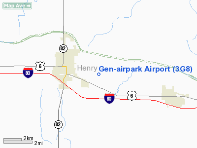
Location: |
Henry County, IL |
|
Magnetic
Variation: |
01E (1985) |
Owner
& Manager
|
Ownership: |
Privately
owned |
|
Owner: |
Gen-air Inc |
|
Address: |
20035 1700 St East
Geneseo, IL 61254 |
|
Phone
number: |
309-944-8126 |
|
Manager: |
Kent Johnson |
|
Address: |
Gen-air Inc, 20035 1700 St East
Geneseo, IL 61254 |
|
Phone
number: |
309-944-8126 |
Airport
Operations and Facilities
|
Airport
Use: |
Open
to public |
|
Wind
indicator: |
Yes |
|
Segmented Circle: |
No |
|
Control
Tower: |
No |
|
Lighting
Schedule: |
SS-SR |
|
Landing
fee charge: |
No |
|
Sectional chart: |
Chicago |
|
Region: |
AGL - Great Lakes |
|
Traffic
Pattern Alt: |
800 ft |
|
Boundary
ARTCC: |
ZAU - Chicago |
|
Tie-in
FSS: |
IKK - Kankakee |
|
FSS
on Airport: |
No |
|
FSS
Toll Free: |
1-800-WX-BRIEF |
|
NOTAMs
Facility: |
IKK (NOTAM-d service avaliable) |
Airport
Communications
|
Runway Information
Runway 09/27
|
Dimension: |
2568
x 120 ft / 782.7 x 36.6 m |
|
Surface: |
TURF, Good Condition |
|
Edge
Lights: |
Non-standard lighting system
NSTD LIRL; NSTD SPACING & INTST. |
|
|
Runway 09 |
Runway 27 |
|
Longitude: |
090-06-53.0242W |
090-06-19.3223W |
|
Latitude: |
41-26-23.5148N |
41-26-22.7840N |
|
Elevation: |
635.00 ft |
635.00 ft |
|
Traffic
Pattern: |
Left |
Left |
|
Displaced
threshold: |
240.00 ft
09/27 DSPLCD THLDS MKD WITH A 10 FT STRIP OF GRAVEL OUTWARD
FM BOTH SIDES OF RY. |
300.00 ft |
|
Obstruction: |
12 ft road
ROAD 3 FT BLO RY END.
APCH RATIO 20:1 TO DSPLCD THR. |
15 ft road, 0.0 ft from runway
APCH RATIO 20:1 TO DSPLCD THLD. |
|
Radio Navigation
Aids
|
ID |
Type |
Name |
Ch |
Freq |
Var |
Dist |
|
EZI |
NDB |
Kewanee |
|
245.00 |
01E |
15.9 nm |
|
BOZ |
NDB |
Whiteside |
|
254.00 |
01E |
21.9 nm |
|
CWI |
NDB |
Clinton |
|
377.00 |
01E |
25.3 nm |
|
VYS |
NDB |
Valley |
|
230.00 |
00W |
43.7 nm |
|
OQW |
NDB |
Maquoketa |
|
386.00 |
02E |
46.4 nm |
|
GBG |
VOR/DME |
Galesburg |
035X |
109.80 |
03E |
33.6 nm |
|
PLL |
VOR/DME |
Polo |
049X |
111.20 |
03E |
41.1 nm |
|
DDD |
VOR/DME |
Port City |
112X |
116.50 |
01E |
47.1 nm |
|
CVA |
VORTAC |
Davenport |
085X |
113.80 |
04E |
23.3 nm |
|
MZV |
VORTAC |
Moline |
091X |
114.40 |
05E |
24.9 nm |
|
BDF |
VORTAC |
Bradford |
094X |
114.70 |
00E |
29.0 nm |
|
PIA |
VORTAC |
Peoria |
099X |
115.20 |
04E |
47.9 nm |
|
DVN |
VOT |
Davenport Municipal |
|
111.80 |
|
23.8 nm |
Remarks
- PARACHUTE
ACTIVITY ON & INVOF ARPT.
- OBSTNS
IN RWY APP SLOPE SFC RMVD/LWRD, OR RWY THR DSPLCD & MKD TO PRVD
20:1 APP OVER OBSTNS.
Gen-airpark Airport
Address:
Henry County, IL
Tel:
309-944-8126
Images
and information placed above are from
http://www.airport-data.com/airport/3G8/
We
thank them for the data!
| General
Info |
| Country |
United
States |
| State |
ILLINOIS
|
| FAA ID |
3G8 |
| Latitude |
41-26-23.200N
|
| Longitude |
090-06-36.200W
|
| Elevation |
645 feet
|
| Near City |
GENESEO
|
We don't guarantee the information is fresh and accurate. The data may
be wrong or outdated.
For more up-to-date information please refer to other sources.
|
|


