|
|
|
 |
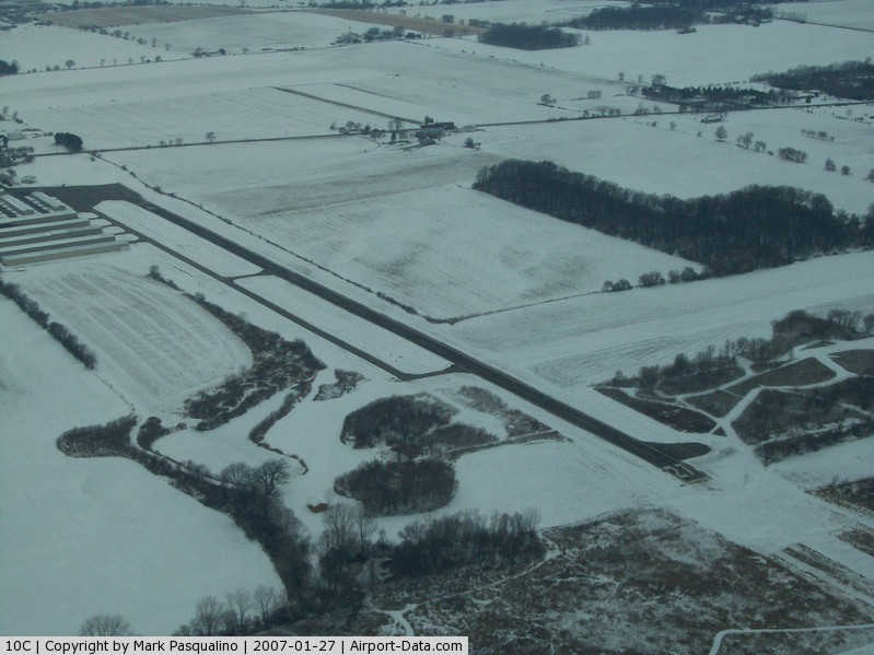
(Click on the photo to enlarge) |
|
 |
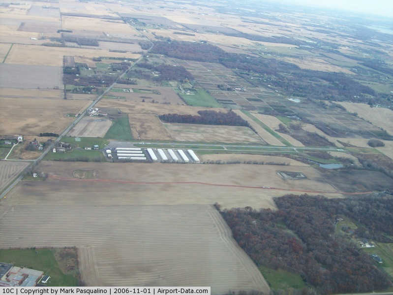
(Click on the photo to enlarge) |
Location
& QuickFacts
|
FAA
Information Effective: |
2007-12-20 |
|
Airport
Identifier: |
10C |
|
Airport
Status: |
Operational |
|
Longitude/Latitude: |
088-22-30.4000W/42-24-10.4000N
-88.375111/42.402889 (Estimated) |
|
Elevation: |
875 ft / 266.70 m (Surveyed) |
|
Land: |
173 acres |
|
From
nearest city: |
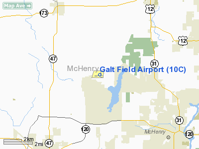
1 nautical miles N of Greenwood/wonder Lake,
IL |
|
Location: |
Mc Henry County, IL |
|
Magnetic
Variation: |
01W (1995) |
Owner
& Manager
|
Ownership: |
Privately
owned |
|
Owner: |
Ivan Djurin & Michael Stanard
TWO OWNERS: GALT AIRPORT LLC & 5112 GREENWOOD ROAD LLC. |
|
Address: |
1475 Amber Road
Glenview, IL 60025 |
|
Phone
number: |
847-776-7455 |
|
Manager: |
Kathy Okon |
|
Address: |
5112 Greenwood Road
Wonder Lake, IL 60097 |
|
Phone
number: |
815-648-4591 |
Airport
Operations and Facilities
|
Airport
Use: |
Open
to public |
|
Wind
indicator: |
Yes |
|
Segmented Circle: |
Yes |
|
Control
Tower: |
No |
|
Lighting
Schedule: |
DUSK-DAWN |
|
Beacon
Color: |
Clear-Green (lighted land airport) |
|
Landing
fee charge: |
No |
|
Sectional chart: |
Chicago |
|
Region: |
AGL - Great Lakes |
|
Traffic
Pattern Alt: |
800 ft |
|
Boundary
ARTCC: |
ZAU - Chicago |
|
Tie-in
FSS: |
IKK - Kankakee |
|
FSS
on Airport: |
No |
|
FSS
Toll Free: |
1-800-WX-BRIEF |
|
NOTAMs
Facility: |
IKK (NOTAM-d service avaliable) |
|
Federal
Agreements: |
N |
Airport
Communications
|
CTAF: |
122.800 |
|
Unicom: |
122.800
|
Airport
Services
|
Fuel
available: |
100LL |
|
Airframe
Repair: |
MAJOR |
|
Power
Plant Repair: |
MAJOR |
|
Bottled
Oxygen: |
HIGH/LOW |
|
Bulk
Oxygen: |
NONE |
|
Runway Information
Runway 09/27
|
Dimension: |
2802
x 36 ft / 854.0 x 11.0 m |
|
Surface: |
ASPH, Fair Condition |
|
Edge
Lights: |
Non-standard lighting system
NSTD LIRL WITH NSTD SPACING; 2669 FT LGTD AT NIGHT. |
|
|
Runway 09 |
Runway 27 |
|
Longitude: |
088-22-52.9369W |
088-22-15.6145W |
|
Latitude: |
42-24-06.2983N |
42-24-07.1966N |
|
Elevation: |
874.00 ft |
848.00 ft |
|
Alignment: |
88 |
127 |
|
Traffic
Pattern: |
Left |
Left |
|
Markings: |
Nonstandard, Fair Condition
09/27 MARKED WITH SOLID WHITE LINE UNDER NUMBERS. |
Nonstandard, Fair Condition |
|
Displaced
threshold: |
0.00 ft
09/27 MARKED FOR NIGHT OPNS WITH THLDS LGTS; NUMBERS UNDERLINED
WITH WHITE STRIPE FOR DAY OPNS. |
139.00 ft |
|
Runway
End Identifier: |
No |
No |
|
Centerline
Lights: |
No |
No |
|
Touchdown
Lights: |
No |
No |
|
Obstruction: |
60 ft tree, 1044.0 ft from runway, 63 ft left
of centerline, 14:1 slope to clear |
28 ft tree, 1131.0 ft from runway, 100 ft left
of centerline, 33:1 slope to clear
RY 27 APCH RATIO 45:1 TO DSPLCD THLD.
+10' TREES @ 60' & 75' R. ARE CLOSE IN
OBSTR. |
|
Runway 18/36
|
Dimension: |
2141
x 125 ft / 652.6 x 38.1 m |
|
Surface: |
TURF, Fair Condition |
|
|
Runway 18 |
Runway 36 |
|
Longitude: |
088-22-25.9470W |
088-22-24.8988W |
|
Latitude: |
42-24-25.6960N |
42-24-04.5643N |
|
Elevation: |
867.00 ft |
855.00 ft |
|
Alignment: |
127 |
127 |
|
Traffic
Pattern: |
Left |
Left |
|
Markings: |
None,
& 36 DSPLCD THLDS MKD WITH A-FRAMES PAINTED BLACK &
YELLOW. |
None, |
|
Displaced
threshold: |
200.00 ft |
270.00 ft |
|
Runway
End Identifier: |
No |
No |
|
Centerline
Lights: |
No |
No |
|
Touchdown
Lights: |
No |
No |
|
Obstruction: |
16 ft tree, 40.0 ft from runway, 50 ft right
of centerline, 2:1 slope to clear
RWY 18 SLOPE IS 15:1 TO DSPLCD THLDS. |
10 ft tree, 0.0 ft from runway, 80 ft right
of centerline
RWY 36 SLOPE IS 0:1 TO DSPLCD THLD. |
|
Radio Navigation
Aids
|
ID |
Type |
Name |
Ch |
Freq |
Var |
Dist |
|
LVV |
NDB |
Lake Lawn |
|
404.00 |
00W |
20.2 nm |
|
RA |
NDB |
Paser |
|
206.00 |
00E |
26.9 nm |
|
ME |
NDB |
Deana |
|
350.00 |
00E |
30.4 nm |
|
DKB |
NDB |
Dekalb |
|
209.00 |
02W |
31.8 nm |
|
JVL |
NDB |
Janesville |
|
375.00 |
03E |
32.2 nm |
|
GM |
NDB |
Teels |
|
242.00 |
02W |
33.8 nm |
|
UES |
NDB |
Waukesha |
|
359.00 |
01W |
39.1 nm |
|
BL |
NDB |
Yanks |
|
260.00 |
02W |
45.2 nm |
|
HK |
NDB |
Ermin |
|
332.00 |
01W |
47.6 nm |
|
RYV |
NDB |
Rock River |
|
371.00 |
01W |
48.8 nm |
|
BUU |
VOR/DME |
Burbun |
092X |
114.50 |
01W |
17.5 nm |
|
OBK |
VOR/DME |
Northbrook |
077X |
113.00 |
02W |
21.7 nm |
|
ENW |
VOR/DME |
Kenosha |
029X |
109.20 |
02W |
22.9 nm |
|
DPA |
VOR/DME |
Dupage |
021X |
108.40 |
02E |
30.8 nm |
|
ORD |
VOR/DME |
Chicago O'hare |
086X |
113.90 |
02E |
32.6 nm |
|
HRK |
VOR/DME |
Horlick |
124X |
117.70 |
02W |
32.9 nm |
|
JVL |
VOR/DME |
Janesville |
090X |
114.30 |
03E |
33.7 nm |
|
RFD |
VOR/DME |
Rockford |
045X |
110.80 |
01E |
38.2 nm |
|
LJT |
VOR/DME |
Timmerman |
072X |
112.50 |
02W |
45.0 nm |
|
BAE |
VORTAC |
Badger |
111X |
116.40 |
02E |
43.1 nm |
|
ORD |
VOT |
Chicago O'hare Intl |
|
112.00 |
|
32.8 nm |
|
MKE |
VOT |
Milwaukee |
|
109.00 |
|
39.0 nm |
|
MDW |
VOT |
Chicago Midway |
|
111.00 |
|
46.3 nm |
Remarks
- PAEW
S OF RY 09/27 & E OF HANGAR.
- DEER
ON & INVOF ARPT.
- PAEW
INVOF ARPT IDEFLY.
- RY
09/27 SOFT EDGES/ 8 IN DROP-OFF.
- EXISTED
PRIOR TO 1959.
Based Aircraft
|
Aircraft
based on field: |
65 |
|
Single
Engine Airplanes: |
61 |
|
Multi
Engine Airplanes: |
3 |
|
Helicopters: |
1 |
Operational Statistics
Time Period: 2004-01-02 - 2004-12-31
|
Aircraft
Operations: |
121/Day |
|
General
Aviation Local: |
38.6% |
|
General
Aviation Itinerant: |
61.4% |
Galt Field Airport
Address:
Mc Henry County, IL
Tel:
847-776-7455,
815-648-4591
Images
and information placed above are from
http://www.airport-data.com/airport/10C/
We
thank them for the data!
| General
Info |
| Country |
United
States |
| State |
ILLINOIS
|
| FAA ID |
10C |
| Latitude |
42-24-10.400N
|
| Longitude |
088-22-30.400W
|
| Elevation |
875 feet
|
| Near City |
GREENWOOD/WONDER
LAKE |
We don't guarantee the information is fresh and accurate. The data may
be wrong or outdated.
For more up-to-date information please refer to other sources.
|
|