 |
|
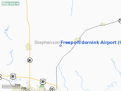
Freeport / Dornink Airport |
|
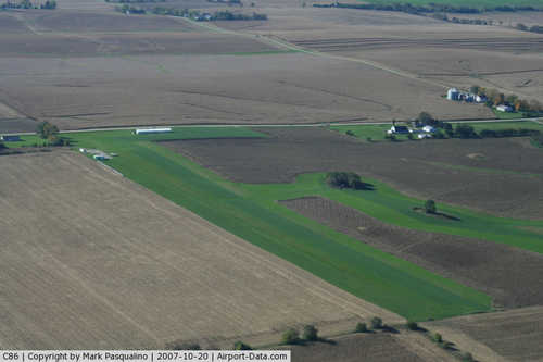 |
(Click on the photo to enlarge) |
Location
& QuickFacts
|
FAA
Information Effective: |
2007-12-20 |
|
Airport
Identifier: |
C86 |
|
Airport
Status: |
Operational |
|
Longitude/Latitude: |
089-33-50.4180W/42-22-40.0580N
-89.564005/42.377794 (Estimated) |
|
Elevation: |
949 ft / 289.26 m (Surveyed) |
|
Land: |
8 acres |
|
From
nearest city: |
6 nautical miles NE of Freeport, IL |
|
Location: |
Stephenson County, IL |
|
Magnetic
Variation: |
00E (1985) |
Owner
& Manager
|
Ownership: |
Privately
owned |
|
Owner: |
Ronald K. Dornink |
|
Address: |
2460 E. Cedarville Rd.
Freeport, IL 61032 |
|
Phone
number: |
815-275-5000 |
|
Manager: |
Ronald K. Dornink |
|
Address: |
1620 Gladewood Dr
Freeport, IL 61032 |
|
Phone
number: |
815-232-6289 |
Airport
Operations and Facilities
|
Airport
Use: |
Open
to public |
|
Wind
indicator: |
Yes |
|
Segmented Circle: |
No |
|
Control
Tower: |
No |
|
Landing
fee charge: |
No |
|
Sectional chart: |
Chicago |
|
Region: |
AGL - Great Lakes |
|
Traffic
Pattern Alt: |
800 ft |
|
Boundary
ARTCC: |
ZAU - Chicago |
|
Tie-in
FSS: |
IKK - Kankakee |
|
FSS
on Airport: |
No |
|
FSS
Toll Free: |
1-800-WX-BRIEF |
|
NOTAMs
Facility: |
IKK (NOTAM-d service avaliable) |
Airport
Communications
|
CTAF: |
122.800 |
|
Unicom: |
122.800
|
Airport
Services
|
Airframe
Repair: |
NONE |
|
Power
Plant Repair: |
NONE |
|
Bottled
Oxygen: |
NONE |
|
Bulk
Oxygen: |
NONE |
|
Runway Information
Runway 18/36
|
Dimension: |
2600 x 100 ft / 792.5 x 30.5 m
RY MOWED 80' WIDE & MARKED WITH CONES ON SIDES. |
|
Surface: |
TURF, Good Condition |
|
|
Runway 18 |
Runway 36 |
|
Longitude: |
089-33-51.4000W |
089-33-51.4100W |
|
Latitude: |
42-22-53.0700N |
42-22-32.0500N |
|
Elevation: |
945.00 ft |
949.00 ft |
|
Traffic
Pattern: |
Left |
Left |
|
Markings: |
None, |
None,
DSPLCD THLD MKD WITH RED & WHITE GROUND MARKERS. |
|
Displaced
threshold: |
0.00 ft |
360.00 ft |
|
Runway
End Identifier: |
No |
No |
|
Centerline
Lights: |
No |
No |
|
Touchdown
Lights: |
No |
No |
|
Obstruction: |
, 50:1 slope to clear |
18 ft road, 40.0 ft from runway, 2:1 slope
to clear
APCH RATIO 22:1 AT DSPLCD THR. |
|
Radio Navigation
Aids
|
ID |
Type |
Name |
Ch |
Freq |
Var |
Dist |
|
FEP |
NDB |
Freeport |
|
335.00 |
00E |
8.0 nm |
|
JVL |
NDB |
Janesville |
|
375.00 |
03E |
27.2 nm |
|
BOZ |
NDB |
Whiteside |
|
254.00 |
01E |
41.3 nm |
|
MS |
NDB |
Monah |
|
400.00 |
00E |
42.3 nm |
|
MRJ |
NDB |
Mineral Point |
|
365.00 |
00W |
42.4 nm |
|
PVB |
NDB |
Platteville |
|
203.00 |
01E |
42.9 nm |
|
DKB |
NDB |
Dekalb |
|
209.00 |
02W |
46.6 nm |
|
LVV |
NDB |
Lake Lawn |
|
404.00 |
00W |
47.1 nm |
|
CWI |
NDB |
Clinton |
|
377.00 |
01E |
47.4 nm |
|
RFD |
VOR/DME |
Rockford |
045X |
110.80 |
01E |
18.6 nm |
|
JVL |
VOR/DME |
Janesville |
090X |
114.30 |
03E |
23.0 nm |
|
PLL |
VOR/DME |
Polo |
049X |
111.20 |
03E |
24.8 nm |
|
MSN |
VORTAC |
Madison |
023X |
108.60 |
03E |
47.2 nm |
Based Aircraft
|
Aircraft
based on field: |
6 |
|
Single
Engine Airplanes: |
6 |
Operational Statistics
Time Period: 2005-01-01 - 2005-12-31
|
Aircraft
Operations: |
125/Week |
|
General
Aviation Local: |
92.3% |
|
General
Aviation Itinerant: |
7.7% |
Freeport/dornink Airport
Address:
Stephenson County, IL
Tel:
815-275-5000,
815-232-6289
Images
and information placed above are from
http://www.airport-data.com/airport/C86/
We
thank them for the data!
| General
Info |
| Country |
United
States |
| State |
ILLINOIS
|
| FAA ID |
C86 |
| Latitude |
42-22-40.058N
|
| Longitude |
089-33-50.418W
|
| Elevation |
949 feet
|
| Near City |
FREEPORT
|
We don't guarantee the information is fresh and accurate. The data may
be wrong or outdated.
For more up-to-date information please refer to other sources.
|
|


