 |
|
| Frasca Field |
| IATA: none – ICAO: none – FAA LID: C16 |
| Summary |
| Airport type |
Public |
| Serves |
Urbana, IL
Champaign, IL |
| Location |
Urbana, IL |
| Elevation AMSL |
735 ft / 224 m |
| Coordinates |
40°08′47″N 88°11′55″W / 40.14639°N 88.19861°W / 40.14639; -88.19861 |
| Runways |
| Direction |
Length |
Surface |
| ft |
m |
| 9/27 |
4001 |
1220 |
Concrete |
| 18/36 |
3654 |
1114 |
Sod |
Frasca Field (FAA LID: C16) is an airport located at the northern edge of Urbana, Illinois in Champaign County, Illinois. It serves the greater Champaign-Urbana Metropolitan Area in East Central Illinois. Frasca Field is located on the opposite side of the city from Willard Airport, and is typically favored by private and corporate operators due to lower traffic volume. Frasca Field is named for the current owner and FBO, Frasca Air Service. Ground Transportation
Frasca Field is located on US Route 45, and is accessible via I-74 exit 184 heading North.
History
Frasca Field was previously owned and operated as Illini Airport by Louis Dyson. In 1980, Illini Airport was acquired by Frasca Air Service, and the name was changed to Frasca Field.
Facilities
Frasca Field has two runways:
- Runway 9/27: 4001 x 55 ft. (1220 x 17 m), Surface: Concrete
- Runway 18/36: 3654 x 140 ft. (1114 x 43 m), Surface: Sod, Displaced Threshold Runway 36.
The above content comes from Wikipedia and is published under free licenses – click here to read more.
|
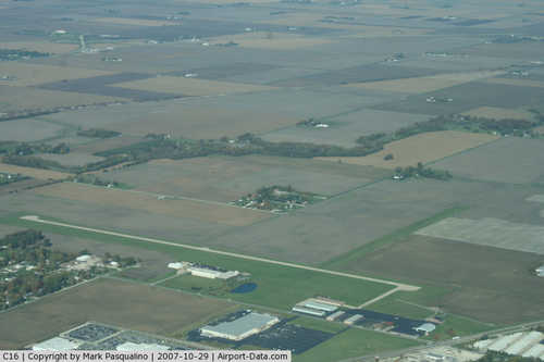 |
(Click on the photo to enlarge) |
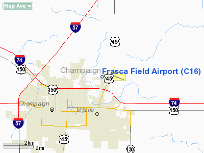
Location
& QuickFacts
|
FAA
Information Effective: |
2007-12-20 |
|
Airport
Identifier: |
C16 |
|
Airport
Status: |
Operational |
|
Longitude/Latitude: |
088-11-54.5553W/40-08-47.0392N
-88.198488/40.146400 (Estimated) |
|
Elevation: |
735 ft / 224.03 m (Surveyed) |
|
Land: |
80 acres |
|
From
nearest city: |
1 nautical miles N of Urbana, IL |
|
Location: |
Champaign County, IL |
|
Magnetic
Variation: |
02E (1965) |
Owner
& Manager
|
Ownership: |
Privately
owned |
|
Owner: |
Frasca Air Service Inc |
|
Address: |
1402 E Airport Road
Urbana, IL 61801 |
|
Phone
number: |
217-367-8441 |
|
Manager: |
Tom Frasca |
|
Address: |
1402 E Arpt Rd
Urbana, IL 61801 |
|
Phone
number: |
217-367-8441 |
Airport
Operations and Facilities
|
Airport
Use: |
Open
to public |
|
Wind
indicator: |
Yes |
|
Segmented Circle: |
No |
|
Control
Tower: |
No |
|
Lighting
Schedule: |
DUSK-DAWN |
|
Landing
fee charge: |
No |
|
Sectional chart: |
Chicago |
|
Region: |
AGL - Great Lakes |
|
Traffic
Pattern Alt: |
800 ft |
|
Boundary
ARTCC: |
ZAU - Chicago |
|
Tie-in
FSS: |
STL - Saint Louis |
|
FSS
on Airport: |
No |
|
FSS
Toll Free: |
1-800-WX-BRIEF |
|
NOTAMs
Facility: |
STL (NOTAM-d service avaliable) |
Airport
Communications
|
CTAF: |
122.800 |
|
Unicom: |
122.800
|
Airport
Services
|
Fuel
available: |
100LLA |
|
Bottled
Oxygen: |
HIGH |
|
Runway Information
Runway 09/27
|
Dimension: |
4001
x 55 ft / 1219.5 x 16.8 m |
|
Surface: |
CONC, Good Condition |
|
Edge
Lights: |
Medium |
|
|
Runway 09 |
Runway 27 |
|
Longitude: |
088-12-27.0951W |
088-11-35.5833W |
|
Latitude: |
40-08-41.9985N |
40-08-42.4001N |
|
Elevation: |
735.00 ft |
724.00 ft |
|
Alignment: |
89 |
127 |
|
Traffic
Pattern: |
Left |
Right |
|
Markings: |
Basic, Good Condition |
Basic, Good Condition |
|
Obstruction: |
58 ft tree, 2123.0 ft from runway, 197 ft right
of centerline, 33:1 slope to clear |
34 ft pole, 1037.0 ft from runway, 199 ft left
of centerline, 24:1 slope to clear |
|
Runway 18/36
|
Dimension: |
3654
x 140 ft / 1113.7 x 42.7 m |
|
Surface: |
TURF, Good Condition |
|
|
Runway 18 |
Runway 36 |
|
Longitude: |
088-11-47.4073W |
088-11-46.8471W |
|
Latitude: |
40-09-10.3911N |
40-08-34.2862N |
|
Elevation: |
728.00 ft |
731.00 ft |
|
Alignment: |
127 |
127 |
|
Traffic
Pattern: |
Left |
Left |
|
Displaced
threshold: |
0.00 ft |
318.00 ft |
|
Obstruction: |
, 50:1 slope to clear |
38 ft pole, 416.0 ft from runway, 101 ft right
of centerline, 10:1 slope to clear
APPCH RATIO IS 20:1 TO THE DSPLCD THLD. |
|
Radio Navigation
Aids
|
ID |
Type |
Name |
Ch |
Freq |
Var |
Dist |
|
HMJ |
NDB |
Homer |
|
281.00 |
01E |
13.4 nm |
|
PRG |
NDB |
Paris |
|
341.00 |
01E |
36.2 nm |
|
MT |
NDB |
Zebre |
|
347.00 |
00E |
42.3 nm |
|
RBS |
VOR/DME |
Roberts |
115X |
116.80 |
02E |
26.2 nm |
|
BMI |
VOR/DME |
Bloomington |
019X |
108.20 |
03E |
39.1 nm |
|
MTO |
VOR/DME |
Mattoon |
031X |
109.40 |
03E |
40.4 nm |
|
PNT |
VOR/DME |
Pontiac |
033X |
109.60 |
03E |
47.4 nm |
|
CMI |
VORTAC |
Champaign |
037X |
110.00 |
03E |
7.6 nm |
|
DNV |
VORTAC |
Danville |
047X |
111.00 |
02E |
30.7 nm |
|
DEC |
VORTAC |
Decatur |
119X |
117.20 |
03E |
39.0 nm |
Remarks
Based Aircraft
|
Aircraft
based on field: |
50 |
|
Single
Engine Airplanes: |
45 |
|
Multi
Engine Airplanes: |
3 |
|
Helicopters: |
1 |
|
Gliders: |
1 |
Operational Statistics
Time Period: 2006-01-01 - 2006-12-31
|
Aircraft
Operations: |
289/Week |
|
Air
Taxi: |
10.0% |
|
General
Aviation Local: |
63.3% |
|
General
Aviation Itinerant: |
26.7% |
Frasca Field Airport
Address:
Champaign County, IL
Tel:
217-367-8441
Images
and information placed above are from
http://www.airport-data.com/airport/C16/
We
thank them for the data!
| General
Info |
| Country |
United
States |
| State |
ILLINOIS
|
| FAA ID |
C16 |
| Latitude |
40-08-46.200N
|
| Longitude |
088-11-54.500W
|
| Elevation |
735 feet
|
| Near City |
URBANA
|
We don't guarantee the information is fresh and accurate. The data may
be wrong or outdated.
For more up-to-date information please refer to other sources.
|
|


