 |
|
|
|
|
|
Location
& QuickFacts
|
FAA
Information Effective: |
2007-12-20 |
|
Airport
Identifier: |
35IS |
|
Airport
Status: |
Operational |
|
Longitude/Latitude: |
088-45-50.2550W/39-31-42.1340N
-88.763960/39.528371 (Estimated) |
|
Elevation: |
676 ft / 206.04 m (Surveyed) |
|
Land: |
0 acres |
|
From
nearest city: |
0 nautical miles W of Findlay, IL |
|
Location: |
Shelby County, IL |
|
Magnetic
Variation: |
00E (1985) |
Owner
& Manager
|
Ownership: |
Privately
owned |
|
Owner: |
Marjorie E. Enoch |
|
Address: |
Route 1 Box 3
Findlay, IL 62534 |
|
Phone
number: |
217-756-8534 |
|
Manager: |
Marjorie E. Enoch |
|
Address: |
Route 1 Box 3
Findlay, IL 62534 |
|
Phone
number: |
217-756-8534 |
Airport
Operations and Facilities
|
Airport
Use: |
Private |
|
Wind
indicator: |
Yes |
|
Segmented Circle: |
No |
|
Control
Tower: |
No |
|
Lighting
Schedule: |
PHONE REQ
FOR RWY LGTS RWY 18/36 PHONE 217-756-8534. |
|
Landing
fee charge: |
No |
|
Sectional
chart: |
St Louis |
|
Region: |
AGL - Great Lakes |
|
Boundary
ARTCC: |
ZKC - Kansas City |
|
Tie-in
FSS: |
STL - Saint Louis |
|
FSS
on Airport: |
No |
|
FSS
Toll Free: |
1-800-WX-BRIEF |
Airport
Services
|
Airframe
Repair: |
NONE |
|
Power
Plant Repair: |
NONE |
|
Runway Information
Runway 18/36
|
Dimension: |
2620
x 90 ft / 798.6 x 27.4 m |
|
Surface: |
TURF, |
|
Edge
Lights: |
Low |
|
|
Runway 18 |
Runway 36 |
|
Traffic
Pattern: |
Left |
Left |
|
Radio Navigation
Aids
|
ID |
Type |
Name |
Ch |
Freq |
Var |
Dist |
|
SYZ |
NDB |
Shelbyville |
|
365.00 |
01E |
8.2 nm |
|
TAZ |
NDB |
Taylorville |
|
395.00 |
00E |
25.9 nm |
|
MT |
NDB |
Zebre |
|
347.00 |
00E |
27.9 nm |
|
CZB |
NDB |
Casey |
|
359.00 |
00E |
37.8 nm |
|
LQ |
NDB |
Licol |
|
375.00 |
01W |
45.1 nm |
|
AAA |
NDB |
Abraham |
|
329.00 |
00E |
46.3 nm |
|
LTD |
NDB |
Litchfield |
|
371.00 |
01E |
47.7 nm |
|
HMJ |
NDB |
Homer |
|
281.00 |
01E |
48.0 nm |
|
SP |
NDB |
Huskk |
|
382.00 |
01W |
48.4 nm |
|
MTO |
VOR/DME |
Mattoon |
031X |
109.40 |
03E |
22.4 nm |
|
DEC |
VORTAC |
Decatur |
119X |
117.20 |
03E |
13.3 nm |
|
VLA |
VORTAC |
Vandalia |
090X |
114.30 |
04E |
32.0 nm |
|
CMI |
VORTAC |
Champaign |
037X |
110.00 |
03E |
37.9 nm |
|
BIB |
VORTAC |
Bible Grove |
027X |
109.00 |
03E |
38.8 nm |
|
CAP |
VORTAC |
Capital |
074X |
112.70 |
04E |
45.4 nm |
|
SPI |
VORTAC |
Spinner |
74X |
112.70 |
01W |
46.2 nm |
Remarks
- RIGHT
TFC PATN COMPATIBLE WITH HOWELL ARPT.
Based Aircraft
|
Aircraft
based on field: |
4 |
|
Single
Engine Airplanes: |
4 |
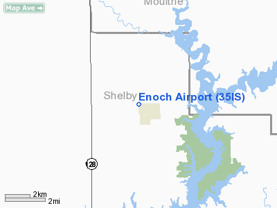
Enoch Airport
Address:
Shelby County, IL
Tel:
217-756-8534
Images
and information placed above are from
http://www.airport-data.com/airport/35IS/
We
thank them for the data!
| General
Info |
| Country |
United
States |
| State |
ILLINOIS
|
| FAA ID |
35IS |
| Latitude |
39-31-42.134N
|
| Longitude |
088-45-50.255W
|
| Elevation |
676 feet
|
| Near City |
FINDLAY
|
We don't guarantee the information is fresh and accurate. The data may
be wrong or outdated.
For more up-to-date information please refer to other sources.
|
|


