 |
|
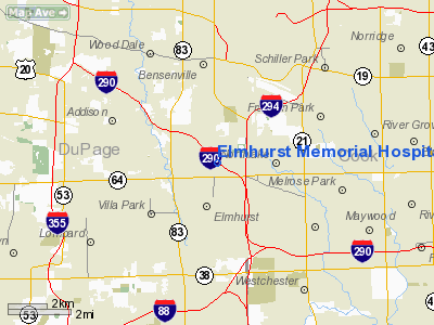
Elmhurst Memorial Hospital Heliport |
Location
& QuickFacts
|
FAA
Information Effective: |
2007-12-20 |
|
Airport
Identifier: |
7IS6 |
|
Airport
Status: |
Operational |
|
Longitude/Latitude: |
087-56-15.0000W/41-54-46.0000N
-87.937500/41.912778 (Estimated) |
|
Elevation: |
705 ft / 214.88 m (Surveyed) |
|
Land: |
0 acres |
|
From
nearest city: |
0 nautical miles N of Elmhurst, IL |
|
Location: |
Du Page County, IL |
|
Magnetic
Variation: |
02W (1995) |
Owner
& Manager
|
Ownership: |
Privately
owned |
|
Owner: |
Elmhurst Meml Hosp |
|
Address: |
200 Berteau Ave
Elmhurst, IL 60126 |
|
Phone
number: |
ELMHURST |
|
Manager: |
Craig Grothaus |
|
Address: |
200 Berteau Ave
Elmhurst, IL 60126 |
|
Phone
number: |
630-833-1400 |
Airport
Operations and Facilities
|
Airport
Use: |
Private |
|
Wind
indicator: |
Yes |
|
Segmented Circle: |
No |
|
Control
Tower: |
No |
|
Lighting
Schedule: |
PHONE REQ
FOR PERIMETER & LEAD-IN LGTS CALL 630-833-1400. |
|
Sectional chart: |
Chicago |
|
Region: |
AGL - Great Lakes |
|
Boundary
ARTCC: |
ZAU - Chicago |
|
Tie-in
FSS: |
IKK - Kankakee |
|
FSS
Toll Free: |
1-800-WX-BRIEF |
|
Runway Information
Helipad HI
|
Dimension: |
40
x 40 ft / 12.2 x 12.2 m |
|
Surface: |
CONC, |
|
|
Runway HI |
Runway |
|
Traffic
Pattern: |
Left |
Left |
|
Radio Navigation
Aids
|
ID |
Type |
Name |
Ch |
Freq |
Var |
Dist |
|
ME |
NDB |
Deana |
|
350.00 |
00E |
5.2 nm |
|
HK |
NDB |
Ermin |
|
332.00 |
01W |
12.5 nm |
|
MX |
NDB |
Kedzi |
|
248.00 |
01W |
15.1 nm |
|
DKB |
NDB |
Dekalb |
|
209.00 |
02W |
34.5 nm |
|
RA |
NDB |
Paser |
|
206.00 |
00E |
46.3 nm |
|
ORD |
VOR/DME |
Chicago O'hare |
086X |
113.90 |
02E |
4.7 nm |
|
DPA |
VOR/DME |
Dupage |
021X |
108.40 |
02E |
18.5 nm |
|
OBK |
VOR/DME |
Northbrook |
077X |
113.00 |
02W |
18.6 nm |
|
ENW |
VOR/DME |
Kenosha |
029X |
109.20 |
02W |
41.3 nm |
|
BUU |
VOR/DME |
Burbun |
092X |
114.50 |
01W |
49.4 nm |
|
JOT |
VORTAC |
Joliet |
070X |
112.30 |
02E |
27.9 nm |
|
CGT |
VORTAC |
Chicago Heights |
089X |
114.20 |
02E |
29.3 nm |
|
EON |
VORTAC |
Peotone |
079X |
113.20 |
02E |
39.2 nm |
|
ORD |
VOT |
Chicago O'hare Intl |
|
112.00 |
|
4.4 nm |
|
MDW |
VOT |
Chicago Midway |
|
111.00 |
|
11.3 nm |
Remarks
- FATO
MEASURES 100 FT BY 100 FT.
- PRVDD
AREA IS MARKED, WIND INDICATOR IS MAINTAINED, APCH ROUTE IS 260 &
040 DEGS & DEP ROUTE IS 080 & 220 DEGS.
Elmhurst Memorial Hospital Heliport
Address:
Du Page County, IL
Tel:
630-833-1400
Images
and information placed above are from
http://www.airport-data.com/airport/7IS6/
We
thank them for the data!
| General
Info |
| Country |
United
States |
| State |
ILLINOIS
|
| FAA ID |
7IS6 |
| Latitude |
41-54-46.000N
|
| Longitude |
087-56-15.000W
|
| Elevation |
705 feet
|
| Near City |
ELMHURST
|
We don't guarantee the information is fresh and accurate. The data may
be wrong or outdated.
For more up-to-date information please refer to other sources.
|
|


