 |
|
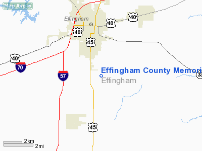
Effingham County Memorial Airport |
Coordinates: 39°04â²14â³N 088°32â²01â³W / 39.07056°N 88.53361°W / 39.07056; -88.53361
| Effingham County Memorial Airport |
| IATA: none â ICAO: none â FAA LID: 1H2 |
| Summary |
| Airport type |
Public |
| Owner |
Effingham County Board |
| Location |
Effingham, Illinois |
| Elevation AMSL |
587 ft / 179 m |
| Website |
co.effingham.il.us/airport.html |
| Runways |
| Direction |
Length |
Surface |
| ft |
m |
| 11/29 |
5,100 |
1,554 |
Concrete |
| 1/19 |
3,400 |
1,036 |
Asphalt |
| Statistics (2007) |
| Aircraft operations |
25,000 |
| Source: Federal Aviation Administration |
Effingham County Memorial Airport (FAA LID: 1H2) is a public airport located three miles (5 km) south of the central business district of Effingham, a city in Effingham County, Illinois, United States. It is owned by the Effingham County Board.
Facilities and aircraft
Effingham County Memorial Airport covers an area of 651 acres (263 ha) which contains two runways: 11/29 with a 5,100 x 75 ft (1,554 x 23 m) concrete pavement and 1/19 with a 3,400 x 60 ft (1,036 x 18 m) asphalt surface. For the 12-month period ending August 31, 2007, the airport had 25,000 aircraft operations, an average of 68 per day: 80% general aviation, 20% air taxi and <1% military.
The above content comes from Wikipedia and is published under free licenses – click here to read more.
|
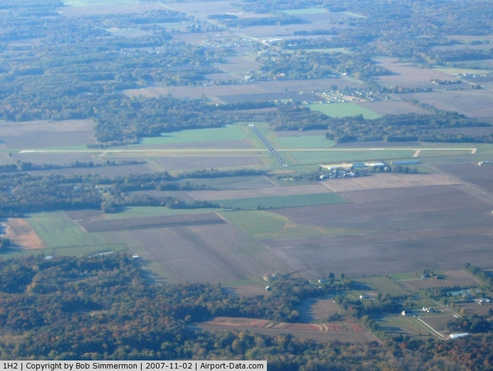 |
(Click on the photo to enlarge) |
Location
& QuickFacts
|
FAA
Information Effective: |
2007-12-20 |
|
Airport
Identifier: |
1H2 |
|
Airport
Status: |
Operational |
|
Longitude/Latitude: |
088-32-00.6710W/39-04-13.6230N
-88.533520/39.070451 (Estimated) |
|
Elevation: |
587 ft / 178.92 m (Estimated) |
|
Land: |
651 acres |
|
From
nearest city: |
3 nautical miles S of Effingham, IL |
|
Location: |
Effingham County, IL |
|
Magnetic
Variation: |
00E (1985) |
Owner
& Manager
|
Ownership: |
Publicly
owned |
|
Owner: |
Effingham County Board |
|
Address: |
307 N 3rd St
Effingham, IL 62401 |
|
Phone
number: |
217-342-9291 |
|
Manager: |
Leon Tate |
|
Address: |
Rr 1 Box 347
Effingham, IL 62401 |
|
Phone
number: |
217-536-5312 |
Airport
Operations and Facilities
|
Airport
Use: |
Open
to public |
|
Wind
indicator: |
Yes |
|
Segmented Circle: |
No |
|
Control
Tower: |
No |
|
Lighting
Schedule: |
DUSK-DAWN
MIRL RY 11/29 PRESET LOW INTST; TO INCR INTST & ACTVT
MIRL RY 01/19; REIL RY 29; VASI RYS 01 & 19 - CTAF. |
|
Beacon
Color: |
Clear-Green (lighted land airport) |
|
Landing
fee charge: |
No |
|
Sectional chart: |
St Louis |
|
Region: |
AGL - Great Lakes |
|
Boundary
ARTCC: |
ZKC - Kansas City |
|
Tie-in
FSS: |
STL - Saint Louis |
|
FSS
on Airport: |
No |
|
FSS
Toll Free: |
1-800-WX-BRIEF |
|
NOTAMs
Facility: |
1H2 (NOTAM-d service avaliable) |
|
Federal
Agreements: |
NGY |
Airport
Communications
|
CTAF: |
122.800 |
|
Unicom: |
122.800
|
Airport
Services
|
Fuel
available: |
100LLA |
|
Airframe
Repair: |
MAJOR |
|
Power
Plant Repair: |
MAJOR |
|
Bottled
Oxygen: |
NONE |
|
Bulk
Oxygen: |
NONE |
|
Runway Information
Runway 01/19
|
Dimension: |
3400
x 60 ft / 1036.3 x 18.3 m |
|
Surface: |
ASPH, Good Condition |
|
Weight
Limit: |
Single wheel: 12000 lbs. |
|
Edge
Lights: |
Medium |
|
|
Runway 01 |
Runway 19 |
|
Longitude: |
088-32-06.0790W |
088-32-00.4390W |
|
Latitude: |
39-03-54.8080N |
39-04-28.1240N |
|
Elevation: |
572.00 ft |
581.00 ft |
|
Alignment: |
7 |
127 |
|
Traffic
Pattern: |
Left |
Left |
|
Markings: |
Non-precision instrument, Good Condition |
Basic, Good Condition |
|
Crossing
Height: |
50.00 ft |
50.00 ft |
|
VASI: |
pulsating/steady burning on left side |
pulsating/steady burning on left side |
|
Visual
Glide Angle: |
3.00° |
3.00° |
|
Centerline
Lights: |
No |
No |
|
Touchdown
Lights: |
No |
No |
|
Obstruction: |
54 ft trees, 1466.0 ft from runway, 434 ft
right of centerline, 23:1 slope to clear |
51 ft tree, 853.0 ft from runway, 42 ft left
of centerline, 12:1 slope to clear |
|
Runway 11/29
|
Dimension: |
5100
x 75 ft / 1554.5 x 22.9 m |
|
Surface: |
CONC, Good Condition |
|
Edge
Lights: |
Medium |
|
|
Runway 11 |
Runway 29 |
|
Longitude: |
088-32-28.7060W |
088-31-29.1820W |
|
Latitude: |
39-04-24.9100N |
39-04-05.2100N |
|
Elevation: |
585.00 ft |
573.00 ft |
|
Alignment: |
113 |
127 |
|
ILS
Type: |
|
LOC/DME
|
|
Traffic
Pattern: |
Left |
Left |
|
Markings: |
Basic, Good Condition |
Non-precision instrument, Good Condition |
|
Runway
End Identifier: |
|
Yes |
|
Obstruction: |
44 ft tree, 1586.0 ft from runway, 192 ft left
of centerline, 31:1 slope to clear |
75 ft tree, 2507.0 ft from runway, 496 ft right
of centerline, 30:1 slope to clear |
|
Radio Navigation
Aids
|
ID |
Type |
Name |
Ch |
Freq |
Var |
Dist |
|
FOA |
NDB |
Elm River |
|
353.00 |
00E |
24.4 nm |
|
SYZ |
NDB |
Shelbyville |
|
365.00 |
01E |
24.8 nm |
|
OLY |
NDB |
Olney |
|
272.00 |
00W |
27.1 nm |
|
MT |
NDB |
Zebre |
|
347.00 |
00E |
27.9 nm |
|
CZB |
NDB |
Casey |
|
359.00 |
00E |
28.5 nm |
|
SLO |
NDB |
Salem |
|
400.00 |
01W |
32.7 nm |
|
PLX |
NDB |
Palestine |
|
391.00 |
00W |
41.8 nm |
|
FWC |
NDB |
Wayne County |
|
257.00 |
01E |
41.9 nm |
|
TAZ |
NDB |
Taylorville |
|
395.00 |
00E |
46.2 nm |
|
AJG |
NDB |
Mount Carmel |
|
524.00 |
02W |
46.8 nm |
|
MTO |
VOR/DME |
Mattoon |
031X |
109.40 |
03E |
27.1 nm |
|
SAM |
VOR/DME |
Samsville |
113X |
116.60 |
03E |
41.0 nm |
|
RSV |
VOR/DME |
Robinson |
021X |
108.40 |
02E |
41.4 nm |
|
VNN |
VOR/DME |
Mount Vernon |
085X |
113.80 |
02E |
44.5 nm |
|
LWV |
VOR/DME |
Lawrenceville |
025X |
108.80 |
01W |
47.1 nm |
|
BIB |
VORTAC |
Bible Grove |
027X |
109.00 |
03E |
9.3 nm |
|
VLA |
VORTAC |
Vandalia |
090X |
114.30 |
04E |
29.4 nm |
|
DEC |
VORTAC |
Decatur |
119X |
117.20 |
03E |
42.8 nm |
|
ENL |
VORTAC |
Centralia |
097X |
115.00 |
04E |
48.9 nm |
Remarks
- TREE
& SILO R TRSN AREA TREE L TRSN AREA RY 19.
- TPA
ESTABLISHED AT 800 FT AGL FOR ALL AIRCRAFT.
Based
Aircraft
|
Aircraft
based on field: |
21 |
|
Single
Engine Airplanes: |
18 |
|
Multi
Engine Airplanes: |
1 |
|
Jet
Engine Airplanes: |
2 |
Operational Statistics
Time Period: 2006-09-01 - 2007-08-31
|
Aircraft
Operations: |
69/Day |
|
Air
Taxi: |
19.6% |
|
General
Aviation Local: |
32.0% |
|
General
Aviation Itinerant: |
48.0% |
|
Military: |
0.4% |
Effingham County Memorial Airport
Address:
Effingham County, IL
Tel:
217-342-9291,
217-536-5312
Images
and information placed above are from
http://www.airport-data.com/airport/1H2/
We
thank them for the data!
| General
Info |
| Country |
United
States |
| State |
ILLINOIS
|
| FAA ID |
1H2 |
| Latitude |
39-04-13.623N
|
| Longitude |
088-32-00.671W
|
| Elevation |
587 feet
|
| Near City |
EFFINGHAM
|
We don't guarantee the information is fresh and accurate. The data may
be wrong or outdated.
For more up-to-date information please refer to other sources.
|
|


