|
|
|
 |
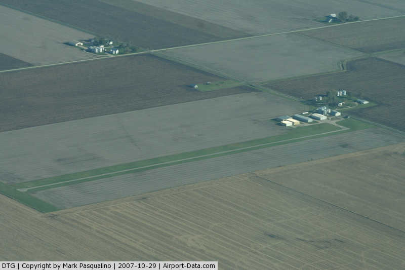
(Click on the photo to enlarge) |
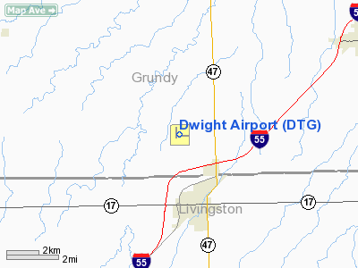
Location
& QuickFacts
|
FAA
Information Effective: |
2007-07-05 |
|
Airport
Identifier: |
DTG |
|
Airport
Status: |
Operational |
|
Longitude/Latitude: |
088-26-26.7220W/41-07-59.9160N
-88.440756/41.133310 (Estimated) |
|
Elevation: |
632 ft / 192.63 m (Surveyed) |
|
Land: |
15 acres |
|
From
nearest city: |
3 nautical miles N of Dwight, IL |
|
Location: |
Grundy County, IL |
|
Magnetic Variation: |
02W (2000) |
Owner
& Manager
|
Ownership: |
Privately
owned |
|
Owner: |
David Constantine |
|
Address: |
10350 S Dwight Rd
Dwight, IL 60420 |
|
Phone
number: |
815-584-2486 |
|
Manager: |
David Constantine |
|
Address: |
10350 S Dwight Rd
Dwight, IL 60420 |
|
Phone number: |
815-584-2486 |
Airport Operations and Facilities
|
Airport
Use: |
Open
to public |
|
Wind
indicator: |
Yes |
|
Segmented Circle: |
No |
|
Control
Tower: |
No |
|
Lighting
Schedule: |
PHONE REQ
FOR LIRL RY 09/27 AFTER 2200 CALL 815-584-2486; FOR ROTG
BCN CALL 815-584-2486. |
|
Beacon
Color: |
Clear-Green (lighted land airport) |
|
Landing
fee charge: |
No |
|
Sectional chart: |
Chicago |
|
Region: |
AGL - Great Lakes |
|
Traffic
Pattern Alt: |
800 ft |
|
Boundary
ARTCC: |
ZAU - Chicago |
|
Tie-in
FSS: |
IKK - Kankakee |
|
FSS
on Airport: |
No |
|
FSS
Toll Free: |
1-800-WX-BRIEF |
|
NOTAMs
Facility: |
IKK (NOTAM-d service avaliable) |
Airport Communications
|
CTAF: |
122.800 |
|
Unicom: |
122.800 |
Airport Services
|
Runway Information
Runway 09/27
|
Dimension: |
2364 x 21 ft / 720.5 x 6.4 m
21' ASPH STRIP CENTERED ON 100' TURF STRIP. |
|
Surface: |
ASPH-TURF, Fair Condition |
|
Edge
Lights: |
Non-standard lighting system
NSTD LIRL; NOT FAA APPROVED L-800 SERIES. SPACING
& INTST OF LGTS VARY. |
|
|
Runway 09 |
Runway 27 |
|
Longitude: |
088-26-34.5610W |
088-26-03.6850W |
|
Latitude: |
41-07-57.0330N |
41-07-57.8440N |
|
Elevation: |
629.00 ft |
623.00 ft |
|
Alignment: |
88 |
127 |
|
Traffic
Pattern: |
Left |
Left |
|
Markings: |
Nonstandard, Fair Condition
/27 NSTD MKGS DUE TO NARROW WIDTH. |
Nonstandard, Fair Condition |
|
Displaced
threshold: |
0.00 ft |
300.00 ft |
|
Runway
End Identifier: |
No |
|
|
Centerline
Lights: |
No |
No |
|
Touchdown
Lights: |
No |
No |
|
Obstruction: |
, 50:1 slope to clear |
17 ft bldg, 389.0 ft from runway, 332 ft right
of centerline, 11:1 slope to clear
APCH RATIO TO DSPLCD THR 40:1; APCH RATIO TO DSPLCD THR OVER
16 FT BLDG 236 FT R OF CNTRLN 1 FT BACK FM DSPLCD THR 0:1.
15 FT RD 185 FT FM RY END 0B CNTRLN; NUMEROUS BLDGS R OF CNTRLN
+299 FT IN FRONT 164 FT IN BACK OF THE RY END WITH MAX TOP
AT 20 FT 237 FT RIGHT OF CNTRLN & 106 FT IN FRONT OF RY
END. |
|
Runway 18/36
|
Dimension: |
2000 x 92 ft / 609.6 x 28.0 m
21' ASPH STRIP CENTERED ON 100' TURF STRIP. |
|
Surface: |
TURF, Good Condition |
|
|
Runway 18 |
Runway 36 |
|
Longitude: |
088-26-36.2220W |
088-26-35.2220W |
|
Latitude: |
41-08-12.6170N |
41-07-53.1160N |
|
Elevation: |
623.00 ft |
632.00 ft |
|
Traffic
Pattern: |
Left |
Left |
|
Markings: |
None, |
None, |
|
Runway
End Identifier: |
No |
No |
|
Centerline
Lights: |
No |
No |
|
Touchdown
Lights: |
No |
No |
|
Radio Navigation
Aids
|
ID |
Type |
Name |
Ch |
Freq |
Var |
Dist |
|
OIX |
NDB |
Ottawa |
|
266.00 |
01E |
23.2 nm |
|
VYS |
NDB |
Valley |
|
230.00 |
00W |
34.6 nm |
|
HK |
NDB |
Ermin |
|
332.00 |
01W |
44.5 nm |
|
DKB |
NDB |
Dekalb |
|
209.00 |
02W |
49.6 nm |
|
MX |
NDB |
Kedzi |
|
248.00 |
01W |
49.8 nm |
|
PNT |
VOR/DME |
Pontiac |
033X |
109.60 |
03E |
23.0 nm |
|
IKK |
VOR/DME |
Kankakee |
053X |
111.60 |
00E |
27.0 nm |
|
RBS |
VOR/DME |
Roberts |
115X |
116.80 |
02E |
35.5 nm |
|
BMI |
VOR/DME |
Bloomington |
019X |
108.20 |
03E |
45.1 nm |
|
DPA |
VOR/DME |
Dupage |
021X |
108.40 |
02E |
45.7 nm |
|
JOT |
VORTAC |
Joliet |
070X |
112.30 |
02E |
25.4 nm |
|
EON |
VORTAC |
Peotone |
079X |
113.20 |
02E |
30.5 nm |
|
CGT |
VORTAC |
Chicago Heights |
089X |
114.20 |
02E |
45.3 nm |
Remarks
- 4
FT FENCE W SIDE IN PRIM SFC OF CNTR SECTION OF RWY 18-36.
Based
Aircraft
|
Aircraft
based on field: |
13 |
|
Single
Engine Airplanes: |
11 |
|
Ultralights: |
2 |
Operational Statistics
Time Period: 2005-01-01
- 2005-12-31
|
Aircraft
Operations: |
39/Week |
|
General
Aviation Local: |
67.5% |
|
General
Aviation Itinerant: |
32.5% |
Dwight Airport
Address:
Grundy County, IL
Tel:
815-584-2486
Images
and information placed above are from
http://www.airport-data.com/airport/DTG/
We
thank them for the data!
| General
Info |
| Country |
United
States |
| State |
ILLINOIS
|
| FAA ID |
DTG |
| Latitude |
41-07-59.916N
|
| Longitude |
088-26-26.722W
|
| Elevation |
632 feet
|
| Near City |
DWIGHT
|
We don't guarantee the information is fresh and accurate. The data may
be wrong or outdated.
For more up-to-date information please refer to other sources.
|
|