|
|
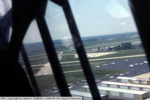
| DuPage Airport |
 |
| FAA airport diagram |
| IATA: DPA â ICAO: KDPA â FAA LID: DPA |
| Summary |
| Airport type |
Public |
| Owner/Operator |
DuPage Airport Authority |
| Location |
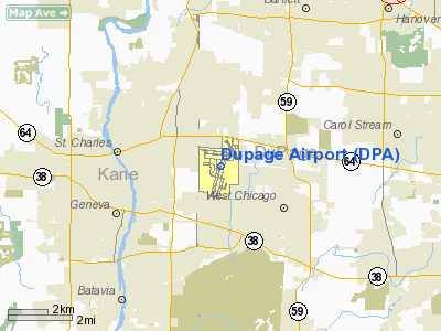
West Chicago, Illinois |
| Elevation AMSL |
759 ft / 231.3 m |
| Coordinates |
41°54â²25â³N 88°14â²54â³W / 41.90694°N 88.24833°W / 41.90694; -88.24833Coordinates: 41°54â²25â³N 88°14â²54â³W / 41.90694°N 88.24833°W / 41.90694; -88.24833 |
| Website |
www.DuPageAirport.com |
| Runways |
| Direction |
Length |
Surface |
| ft |
m |
| 2L/20R |
7,570 |
2,307 |
Concrete |
| 2R/20L |
5,100 |
1,554 |
Concrete |
| 10/28 |
4,751 |
1,448 |
Asphalt |
| 15/33 |
3,401 |
1,037 |
Asphalt |
| Statistics (2008) |
| Aircraft operations |
99,802 |
| Based aircraft |
365 |
| Source: FAA |
DuPage Airport (IATA: DPA, ICAO: KDPA, FAA LID: DPA) is a general aviation airport located 29 miles (47 km) west of downtown Chicago in West Chicago, DuPage County, Illinois. It is owned and operated by the DuPage Airport Authority, which is an independent government body established by law by the State of Illinois. It also serves as a reliever airport for O'Hare International Airport and Chicago Midway International Airport. History
DuPage Airport is located on what used to be sheep-grazing land, but in 1927, two Chicago entrepreneurs purchased the land and began barnstorming, using the field as a grass strip. In 1941, the U.S. Navy requisitioned DuPage Airport, built brick hangars, paved two runways in an âXâ pattern and began training pilots for the war effort. The airport was officially activated in March 1943. Both the hangars and the original runway configuration still exist, though one runway is closed and is now taxiway C.
A year after the Navy began operations, Howard Aircraft Corporation opened a factory east of the airport across the road. The company built more than 500 trainer, transport and air ambulance aircraft for the military, and Howard employees were regularly seen pushing aircraft across the road to the little airport to test fly them.
In 1946, with the war over, the Navy sold the airport to DuPage County for $1. The post-war boom saw a lot of regional growth and the airport reflected it by adding an east/west runway and a five-story control tower and making plans for further expansion.
In the late 1970s, DuPage Airport was designated a reliever airport for general aviation aircraft, and in the early 1980s, the airport authority began an expansion project to accommodate the increased traffic.
However, planners learned a lesson from the plight of the beleaguered, land-locked Midway Airport. Surrounded by houses, restaurants and other small businesses, Midway found itself unable to expand and neighbors filed an endless succession of noise complaints. DuPage County would not make the same mistake.
The airport grew from 900 acres (360 ha) in 1985 to 2,800 acres (1,100 ha) by 1992, with the goal of maintaining control of all the property surrounding the runway complex. Much of the land was acquired to provide a large buffer zone around the airport.
Facilities and aircraft
The DuPage Airport Authority owns 2,800 acres (1,100 ha) and operates four separate business units. This multifaceted business portfolio includes the DuPage Airport, one of the busiest airports in Illinois, its associated fixed base operator, a Robert Trent Jones, Jr. designed golf course, and the largest corporate research and development park in DuPage County.
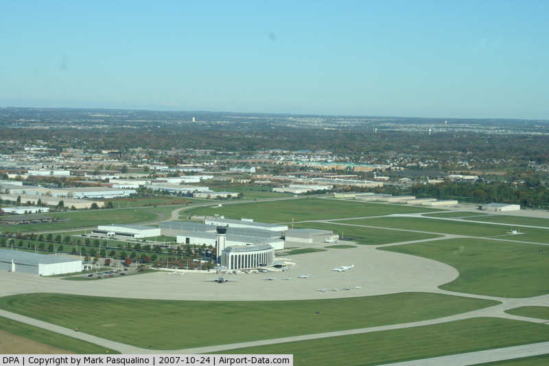
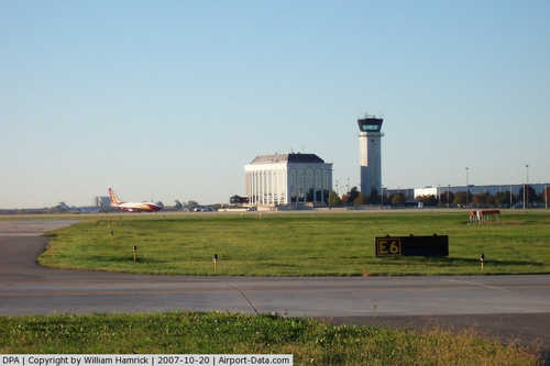
DuPage Airport sits on 1,200 acres (490 ha) and is the only general aviation airport in Illinois with four active runways, two ILS approaches, a 24-hour FAA air control tower, and over 40 aviation and non-aviation support businesses. DPA also has an on-site U.S. Customs Office.
For the 12-month period ending July 31, 2008, the airport had 99,802 aircraft operations, an average of 273 per day: 95% general aviation, 4% air taxi, <1% military, and <1% scheduled commercial. There are 365 aircraft based at this airport: 69% single-engine, 14% multi-engine, 16% jet, and 1% helicopter.
DuPage Airport also serves at he Wing Headquarters for Illinois wing civil air patrol.
Reception
The airport has faced severe political criticism in the 1980s and 1990s. A 1995 Chicago magazine exposé called it "A Monument to Lavish Spending of Taxpayers' Money, a Haven of GOP Patronage, and the Target of a Federal Probe."
According to an article by John K. Wilson:
- Philip, the patron of DuPage airport, helped push forward a disastrously expensive enterprise which included land purchases making it four times the size of Midway Airport, a $10 million terminal, a $14 million golf course, and a charter airline run by the airport. The DuPage Airport budget grew from $1.6 million in 1984 to $46 million in 1993 at a time when airport use was declining. In 1992, DuPage Airport handled only 177,000 takeoffs and landings, while Aurora Municipal Airport took care of 134,000 takeoffs and landings at a cost of only $2 million.
According to a May 2006 article in Aviation International News:
- Before 2003, the airport had been on a trend of worsening annual operating losses. That trend was reversed in 2003 and the airport has continued to show improved operating results each quarter since. Last year the airport experienced a record-breaking year, with revenue up and expenditures down. The cornerstone of the airportâs financial turnaround is the mission statement developed by the airportâs Board of Commissioners in 2003. It establishes the framework for moving the airport toward operating as a self-sustaining facility while contributing to the economic impact of the county. The aggressive philosophy has resulted in two leases that will bring 60,000 sq ft (6,000 m) of new hangar space to the airport. The airport is also developing another 48,000 sq ft (4,500 m) of hangar space.
In June of 2010, the board of the DuPage National Technology Park, an 800 acre technology park that secured a $34 million state grant called for the dissolution of their organization.
The above content comes from Wikipedia and is published under free licenses – click here to read more.
|
 |
(Click on the photo to enlarge) |
|
 |
(Click on the photo to enlarge) |
|
 |
(Click on the photo to enlarge) |
|
 |
(Click on the photo to enlarge) |
Location
& QuickFacts
|
FAA
Information Effective: |
2007-07-05 |
|
Airport
Identifier: |
DPA |
|
Airport
Status: |
Operational |
|
Longitude/Latitude: |
088-14-55.0000W/41-54-28.0000N
-88.248611/41.907778 (Estimated) |
|
Elevation: |
758 ft / 231.04 m (Surveyed) |
|
Land: |
2800 acres |
|
From
nearest city: |
29 nautical miles W of Chicago/west Chicago,
IL |
|
Location: |
Du Page County, IL |
|
Magnetic Variation: |
01W (1985) |
Owner
& Manager
|
Ownership: |
Publicly
owned |
|
Owner: |
Dupage Arpt Auth |
|
Address: |
2700 International Drive Ste 200
West Chicago, IL 60185-0787 |
|
Phone
number: |
630-584-2211 |
|
Manager: |
David Bird |
|
Address: |
2700 Int'l Drive, Ste 200
West Chicago, IL 60185-0787 |
|
Phone number: |
630-584-2211 |
Airport Operations and Facilities
|
Airport
Use: |
Open
to public |
|
Wind
indicator: |
Yes |
|
Segmented Circle: |
No |
|
Control
Tower: |
Yes |
|
Lighting
Schedule: |
ATC-CTL |
|
Beacon
Color: |
Clear-Green (lighted land airport) |
|
Landing
fee charge: |
No |
|
Sectional chart: |
Chicago |
|
Region: |
AGL - Great Lakes |
|
Traffic
Pattern Alt: |
800 ft |
|
Boundary
ARTCC: |
ZAU - Chicago |
|
Tie-in
FSS: |
IKK - Kankakee |
|
FSS
on Airport: |
No |
|
FSS
Toll Free: |
1-800-WX-BRIEF |
|
NOTAMs
Facility: |
DPA (NOTAM-d service avaliable) |
|
Federal Agreements: |
NGRY |
Airport Communications
Airport
Services
|
Fuel
available: |
100LLA |
|
Airframe
Repair: |
MAJOR |
|
Power
Plant Repair: |
MAJOR |
|
Bottled
Oxygen: |
HIGH/LOW |
|
Bulk
Oxygen: |
HIGH/LOW |
|
Runway Information
Runway 02L/20R
|
Dimension: |
7570
x 100 ft / 2307.3 x 30.5 m |
|
Surface: |
CONC, Good Condition |
|
Surface
Treatment: |
Saw-cut or plastic Grooved |
|
Weight
Limit: |
Single wheel: 30000 lbs.
Dual wheel: 45000 lbs. |
|
Edge
Lights: |
High |
|
|
Runway 02L |
Runway 20R |
|
Longitude: |
088-15-12.7786W |
088-14-48.5313W |
|
Latitude: |
41-53-38.5103N |
41-54-51.0740N |
|
Elevation: |
751.00 ft |
756.00 ft |
|
Alignment: |
14 |
127 |
|
ILS
Type: |
ILS |
|
|
Traffic
Pattern: |
Left |
Left |
|
Markings: |
Precision instrument, Good Condition |
Basic, Good Condition |
|
Crossing
Height: |
0.00 ft |
31.00 ft |
|
VASI: |
|
4-light PAPI on left side |
|
Visual
Glide Angle: |
0.00° |
3.00° |
|
Approach
lights: |
MALSR |
|
|
Centerline
Lights: |
Yes |
Yes |
|
Touchdown
Lights: |
Yes |
No |
|
Obstruction: |
, 50:1 slope to clear |
79 ft tree, 2823.0 ft from runway, 475 ft right
of centerline, 33:1 slope to clear |
|
Runway 02R/20L
|
Dimension: |
5100
x 100 ft / 1554.5 x 30.5 m |
|
Surface: |
CONC, Good Condition |
|
Surface
Treatment: |
Saw-cut or plastic Grooved |
|
Weight
Limit: |
Single wheel: 30000 lbs.
Dual wheel: 45000 lbs. |
|
Edge
Lights: |
Medium |
|
|
Runway 02R |
Runway 20L |
|
Longitude: |
088-14-59.7100W |
088-14-43.3812W |
|
Latitude: |
41-53-36.0800N |
41-54-24.9616N |
|
Elevation: |
751.00 ft |
754.00 ft |
|
Alignment: |
14 |
127 |
|
Traffic
Pattern: |
Right |
Left |
|
Markings: |
Non-precision instrument, Good Condition |
Non-precision instrument, Good Condition |
|
Obstruction: |
52 ft bldg, 2484.0 ft from runway, 96 ft right
of centerline, 43:1 slope to clear |
, 50:1 slope to clear |
|
Runway 10/28
|
Dimension: |
4751
x 75 ft / 1448.1 x 22.9 m |
|
Surface: |
ASPH, Good Condition |
|
Surface
Treatment: |
Porous Friction Course |
|
Weight
Limit: |
Single wheel: 30000 lbs.
Dual wheel: 45000 lbs. |
|
Edge
Lights: |
High |
|
|
Runway 10 |
Runway 28 |
|
Longitude: |
088-15-30.5680W |
088-14-28.0860W |
|
Latitude: |
41-54-48.5170N |
41-54-43.6030N |
|
Elevation: |
753.00 ft |
756.00 ft |
|
Alignment: |
96 |
127 |
|
ILS
Type: |
ILS |
|
|
Traffic
Pattern: |
Left |
Left |
|
Markings: |
Precision instrument, Good Condition |
Precision instrument, Good Condition |
|
Crossing
Height: |
50.00 ft |
43.00 ft |
|
Displaced
threshold: |
0.00 ft |
750.00 ft |
|
VASI: |
4-box on left side |
4-box on left side
OTS INDEFLY |
|
Visual
Glide Angle: |
3.00° |
3.00° |
|
Approach
lights: |
LDIN |
|
|
Runway
End Identifier: |
Yes |
Yes |
|
Obstruction: |
27 ft bldg, 1372.0 ft from runway, 17 ft right
of centerline, 43:1 slope to clear |
64 ft tree, 874.0 ft from runway, 347 ft right
of centerline, 10:1 slope to clear
APCH RATIO 25:1 TO DSPLCD THLD. |
|
Runway 15/33
|
Dimension: |
3401
x 100 ft / 1036.6 x 30.5 m |
|
Surface: |
ASPH, Good Condition |
|
Weight
Limit: |
Single wheel: 30000 lbs.
Dual wheel: 45000 lbs.
Dual tandem wheel: 100000 lbs. |
|
Edge
Lights: |
Medium |
|
|
Runway 15 |
Runway 33 |
|
Longitude: |
088-14-44.6640W |
088-14-20.5290W |
|
Latitude: |
41-55-09.2160N |
41-54-40.8650N |
|
Elevation: |
757.00 ft |
758.00 ft |
|
Alignment: |
127 |
127 |
|
Traffic
Pattern: |
Left |
Left |
|
Markings: |
Basic, Good Condition |
Basic, Good Condition |
|
Crossing
Height: |
42.00 ft |
0.00 ft |
|
Displaced
threshold: |
0.00 ft |
190.00 ft |
|
VASI: |
4-light PAPI on right side |
|
|
Visual
Glide Angle: |
3.90° |
0.00° |
|
Runway
End Identifier: |
Yes |
Yes |
|
Obstruction: |
68 ft tree, 1215.0 ft from runway, 162 ft left
of centerline, 14:1 slope to clear |
79 ft tree, 1685.0 ft from runway, 172 ft left
of centerline, 18:1 slope to clear
APCH RATIO IS 23:1 TO DSPLCD THLD.
+13 FT ROAD 199 FT FM RY END 125 FT R. |
|
Radio Navigation
Aids
|
ID |
Type |
Name |
Ch |
Freq |
Var |
Dist |
|
ME |
NDB |
Deana |
|
350.00 |
00E |
10.6 nm |
|
DKB |
NDB |
Dekalb |
|
209.00 |
02W |
20.6 nm |
|
HK |
NDB |
Ermin |
|
332.00 |
01W |
21.7 nm |
|
MX |
NDB |
Kedzi |
|
248.00 |
01W |
27.0 nm |
|
OIX |
NDB |
Ottawa |
|
266.00 |
01E |
42.6 nm |
|
RA |
NDB |
Paser |
|
206.00 |
00E |
49.1 nm |
|
LVV |
NDB |
Lake Lawn |
|
404.00 |
00W |
50.0 nm |
|
DPA |
VOR/DME |
Dupage |
021X |
108.40 |
02E |
4.7 nm |
|
ORD |
VOR/DME |
Chicago O'hare |
086X |
113.90 |
02E |
16.1 nm |
|
OBK |
VOR/DME |
Northbrook |
077X |
113.00 |
02W |
23.0 nm |
|
ENW |
VOR/DME |
Kenosha |
029X |
109.20 |
02W |
43.9 nm |
|
RFD |
VOR/DME |
Rockford |
045X |
110.80 |
01E |
46.5 nm |
|
BUU |
VOR/DME |
Burbun |
092X |
114.50 |
01W |
47.0 nm |
|
JOT |
VORTAC |
Joliet |
070X |
112.30 |
02E |
21.9 nm |
|
CGT |
VORTAC |
Chicago Heights |
089X |
114.20 |
02E |
38.7 nm |
|
EON |
VORTAC |
Peotone |
079X |
113.20 |
02E |
43.5 nm |
|
ORD |
VOT |
Chicago O'hare Intl |
|
112.00 |
|
15.9 nm |
|
MDW |
VOT |
Chicago Midway |
|
111.00 |
|
23.4 nm |
Remarks
- DEER,
BIRDS & MIGRATORY WATERFOWL ON & INVOF ARPT.
- ACFT
ON SHORT FINAL TO RY 15 ARE NOT VSB FROM ATCT DUE TO TREES.
Based
Aircraft
|
Aircraft
based on field: |
472 |
|
Single
Engine Airplanes: |
346 |
|
Multi
Engine Airplanes: |
80 |
|
Jet
Engine Airplanes: |
43 |
|
Helicopters: |
3 |
Operational Statistics
Time Period: 2005-01-01
- 2005-12-31
|
Aircraft
Operations: |
366/Day |
|
Commerical: |
0.0% |
|
Air
Taxi: |
4.3% |
|
General
Aviation Local: |
37.8% |
|
General
Aviation Itinerant: |
57.8% |
|
Military: |
0.1% |
Dupage Airport
Address:
Du Page County, IL
Tel:
630-584-2211
Images
and information placed above are from
http://www.airport-data.com/airport/DPA/
We
thank them for the data!
| General
Info |
| Country |
United
States |
| State |
ILLINOIS
|
| FAA ID |
DPA |
| Latitude |
41-54-28.000N
|
| Longitude |
088-14-55.000W
|
| Elevation |
758 feet
|
| Near City |
CHICAGO/WEST
CHICAGO |
We don't guarantee the information is fresh and accurate. The data may
be wrong or outdated.
For more up-to-date information please refer to other sources.
|
|